Weihai
Weihai (Chinese: 威海; pinyin: Wēihǎi), formerly called Weihaiwei (traditional Chinese: 威海衞; simplified Chinese: 威海卫; pinyin: Wēihǎiwèi; lit.: 'powerful sea guard'), is a prefecture-level city and major seaport in easternmost Shandong province. It borders Yantai to the west and the Yellow Sea to the east, and is the closest Chinese city to South Korea.
Weihai 威海市 | |
|---|---|
 The Happiness Gate is a landmark of Weihai | |
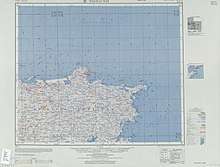
 Weihai City in Shandong | |
 Weihai Location in China | |
| Coordinates (Weihai municipal government): 37°30′48″N 122°07′14″E | |
| Country | People's Republic of China |
| Province | Shandong |
| County-level divisions | 4 |
| Township-level divisions | 66 |
| Municipal seat | Huancui District |
| Government | |
| • CPC Secretary | Wang Luming (王鲁明) |
| • Mayor | Zhang Haibo (张海波) |
| Area | |
| • Prefecture-level city | 5,797 km2 (2,238 sq mi) |
| • Urban | 2,605.9 km2 (1,006.1 sq mi) |
| • Metro | 776.7 km2 (299.9 sq mi) |
| Population (2010 census) | |
| • Prefecture-level city | 2,804,771 |
| • Density | 480/km2 (1,300/sq mi) |
| • Urban | 1,517,935 |
| • Urban density | 580/km2 (1,500/sq mi) |
| • Metro | 844,310 |
| • Metro density | 1,100/km2 (2,800/sq mi) |
| Time zone | UTC+08:00 (China Standard) |
| Area code(s) | 631 |
| ISO 3166 code | CN-SD-10 |
| GDP | RMB178 billion (2008) |
| GDP per capita | RMB63,519 (2008) |
| License Plate Prefix | 鲁K |
| Administrative division code | 371000 |
| Website | www.weihai.gov.cn |
| City Flower: Sweet Osmanthus, Osmanthus fragrans City Tree: Silk Tree, Albizia julibrissin | |
Weihai's population was 2,804,771 as of the 2010 census. Amongst them, 844,310 lived in the current built-up (metro) area (Huancui district) even though Wendeng district is soon being conurbated. Rongcheng, a county-level city within Weihai, has a built up area with 714,355 inhabitants. A subway is planned with 4 lines and 204.6 km (127.1 mi) route length to link all city districts. The first phase, Line 1 and 2 is planned for 2025.
Between 1898 and 1930, the city was part of the British leased territory of Weihaiwei; during this time, the city itself was known as Port Edward and served as the capital of Weihaiwei.[1]
History
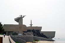
Weihaiwei was the base for the Beiyang Fleet during the Qing Dynasty. In 1895, the Japanese captured it in the Battle of Weihaiwei, which is regarded as the last major battle of the First Sino-Japanese War. The Japanese then evacuated on 24 May 1898, when it was then occupied by the British.[2] Since 2003, a replica of the Chinese battleship Dingyuan has been anchored here as a museum ship and memorial for First Sino-Japanese War Chinese veterans.
Weihaiwei was under British rule from 1 July 1898, under lease agreement with the Chinese empire, until 1930, with 'Port Edward' (Weihaiwei city) serving as the capital. A Royal Navy base was built on Liugong Island. Weihaiwei became a special administrative region after it was returned to the Republic of China on 1 October 1930,[3][4] but Liugong Island and its facilities were leased back to the U.K. until 1940.[2]
In 1938, the Roman Catholic Independent Mission of Weihai was promoted to Apostolic Prefecture of Weihai but it has been vacant (dormant) since 1970.[5] Weihaiwei was occupied by the Japanese from 1938 to 1945.[6] There was a withdrawal of most British forces and supplies from Liugong Island, and finally a Japanese military landing and occupation of the island in 1940.[7]
The region was formally incorporated into Shandong province on 10 May 1945.[6] In 1949, Weihaiwei City was established, and its name was shortened to Weihai after the Communist revolution.
Economy
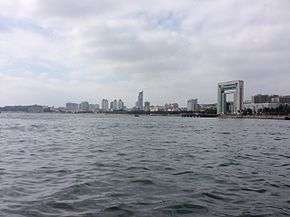
Weihai is a commercial port and major fishing center with some light industries. Due to its close proximity to South Korea, Weihai also has a large Korean business community and receives many Korean tourists. Weihai is also a key production area for peanuts and fruit.
Industrial Zone
Weihai Economic & Technological Development Zone is a state-level development zone approved by the State Council on October 21, 1992. The administrative area has an area of 194 km2 (75 sq mi), including the programmed area of 36 km2 (14 sq mi) and an initial area of 11.88 km2 (4.59 sq mi). Its nearest port is Weihai Port, and the airport closest to the zone is Dashuibo Airport.[8]
Weihai Export Processing Zone (EPZ) was set up by the approval of the State Council on April 27, 2000. Weihai EPZ is located in Weihai Economic & Technological Development Zone with programmed area of 2.6 km2 (1.0 sq mi). Weihai EPZ belongs to comprehensive export & processing zone. The EPZ is located 30 km (19 mi) from Weihai Airport, 3 km (1.9 mi) to Weihai Railway Station and 4 km (2.5 mi) from Weihai Harbor.[9]
Weihai Torch Hi-Tech Science Park is a state-level development zone approved by the State Council on March 1991. Located in Weihai's northwest zone of culture, education and science, the Park has the total area of 111.9 km2 (43.2 sq mi), a coastline of 30.5 km (19.0 mi) and 150,000 residents. It is 3 km (1.9 mi) away from the city center, 4 km (2.5 mi) away from Weihai Port, 10 km (6.2 mi) away from Weihai Railway Station, 30 km (19 mi) away from Weihai Airport and 80 km (50 mi) away from Yantai Airport.[10]
Transportation
Weihai Dashuibo Airport serves the city with regular service to Beijing, Shanghai, Guangzhou, Harbin domestically and the Korean cities of Seoul and Busan, as the fourth busiest airport in Shandong following Qingdao, Jinan and Yantai.
Qingdao–Rongcheng intercity railway offers the high-speed rail services directly to Shanghai Hongqiao, Beijing South, Jinan, Jimo North (Qingdao North soon) and Yantai, with five rail stations, Weihai, Weihai North, Wendeng, Wendeng East and Rongcheng.
As for conventional rail services, The K8262 train depart every day at and 10:18 PM respectively for Jinan, the provincial capital, the K412 goes directly to Beijing at 8:54 PM, and the No. K1068 train leaves at 9:38 AM for Hankou, one of the three railway stations of Wuhan, Hubei. Internally, the city is served by more than 50 bus routes.
Administrative divisions
The prefecture-level city of Weihai administers four county-level divisions, including two districts and two county-level cities.
| Map | ||
|---|---|---|
| Subdivision | Chinese | Pinyin |
| Huancui District | 环翠区 | Huáncuì Qū |
| Wendeng District | 文登区 | Wéndēng Qū |
| Rongcheng | 荣成市 | Róngchéng Shì |
| Rushan | 乳山市 | Rǔshān Shì |
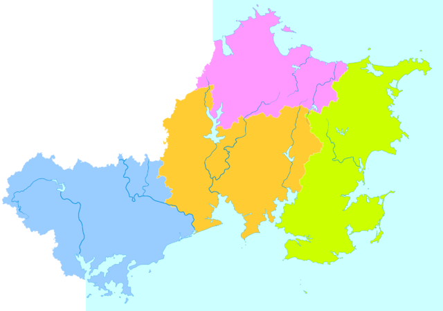
These are further divided into 66 township-level divisions, including 52 towns and 14 subdistricts.
Geography and climate
| Weihai | ||||||||||||||||||||||||||||||||||||||||||||||||||||||||||||
|---|---|---|---|---|---|---|---|---|---|---|---|---|---|---|---|---|---|---|---|---|---|---|---|---|---|---|---|---|---|---|---|---|---|---|---|---|---|---|---|---|---|---|---|---|---|---|---|---|---|---|---|---|---|---|---|---|---|---|---|---|
| Climate chart (explanation) | ||||||||||||||||||||||||||||||||||||||||||||||||||||||||||||
| ||||||||||||||||||||||||||||||||||||||||||||||||||||||||||||
| ||||||||||||||||||||||||||||||||||||||||||||||||||||||||||||
Weihai is located on the northeastern shore of Shandong; its administrative area includes Chengshantou (成山头), the eastern tip of the Shandong Peninsula (Shantung Peninsula). The city is surrounded by sea on three sides; its port is protected by Liugong Island.
Weihai lies in the humid subtropical climate zone (Köppen Cwa) in terms of latitude, but as it is at the eastern end of the Shandong Peninsula, its climate is strongly influenced by the surrounding Yellow Sea as well as the Siberian high and therefore experiences a humid continental climate. Springtime warming and autumn cooling are delayed by one month, winds are generally high, and the average diurnal temperature variation throughout the year is small—at only 6.73 °C (12.1 °F). Winters are cold and dry, but still warmer than inland places located at the same latitude; the average temperature in January is −0.9 °C (30.4 °F). Summers are hot and humid, and August averages 24.7 °C (76.5 °F); the annual mean is 12.48 °C (54.5 °F). More than two-thirds of the annual precipitation occurs from June to September, and there are nearly 2,540 hours of sunshine per year.
| Climate data for Weihai (1971–2000) | |||||||||||||
|---|---|---|---|---|---|---|---|---|---|---|---|---|---|
| Month | Jan | Feb | Mar | Apr | May | Jun | Jul | Aug | Sep | Oct | Nov | Dec | Year |
| Record high °C (°F) | 13.6 (56.5) |
19.8 (67.6) |
23.4 (74.1) |
29.6 (85.3) |
34.2 (93.6) |
38.4 (101.1) |
37.4 (99.3) |
35.4 (95.7) |
33.7 (92.7) |
30.4 (86.7) |
24.0 (75.2) |
18.0 (64.4) |
38.4 (101.1) |
| Average high °C (°F) | 2.0 (35.6) |
3.4 (38.1) |
8.5 (47.3) |
16.0 (60.8) |
21.6 (70.9) |
25.5 (77.9) |
27.8 (82.0) |
27.8 (82.0) |
24.4 (75.9) |
19.1 (66.4) |
11.8 (53.2) |
5.2 (41.4) |
16.1 (61.0) |
| Daily mean °C (°F) | −0.9 (30.4) |
0.1 (32.2) |
4.6 (40.3) |
11.4 (52.5) |
16.9 (62.4) |
21.2 (70.2) |
24.3 (75.7) |
24.7 (76.5) |
21.2 (70.2) |
15.6 (60.1) |
8.5 (47.3) |
2.1 (35.8) |
12.5 (54.5) |
| Average low °C (°F) | −3.4 (25.9) |
−2.5 (27.5) |
1.3 (34.3) |
7.5 (45.5) |
12.8 (55.0) |
17.7 (63.9) |
21.3 (70.3) |
22.0 (71.6) |
18.2 (64.8) |
12.4 (54.3) |
5.5 (41.9) |
−0.5 (31.1) |
9.4 (48.8) |
| Record low °C (°F) | −12.3 (9.9) |
−13.2 (8.2) |
−8.6 (16.5) |
−1.2 (29.8) |
5.7 (42.3) |
10.7 (51.3) |
14.4 (57.9) |
15.3 (59.5) |
7.5 (45.5) |
0.8 (33.4) |
−7.4 (18.7) |
−11.3 (11.7) |
−13.2 (8.2) |
| Average precipitation mm (inches) | 12.9 (0.51) |
12.2 (0.48) |
17.8 (0.70) |
36.1 (1.42) |
49.0 (1.93) |
74.5 (2.93) |
132.6 (5.22) |
175.7 (6.92) |
79.9 (3.15) |
37.3 (1.47) |
29.9 (1.18) |
22.1 (0.87) |
680.0 (26.77) |
| Average precipitation days (≥ 0.1 mm) | 6.5 | 5.1 | 4.6 | 5.8 | 6.9 | 7.9 | 11.5 | 10.2 | 6.9 | 6.4 | 7.8 | 8.2 | 87.8 |
| Source: Weather China | |||||||||||||
Education
Campuses of Shandong University, Harbin Institute of Technology, Beijing Jiaotong University, Harbin University of Science and Technology, as well as Shandong Jiaotong University are located in Weihai.
Eponymy
- The minor planet 207931 Weihai is named after this city.
See also
References
Citations
- Weihai, Encyclopædia Britannica Online. Encyclopædia Britannica Inc. 8 October 2015. Archived from the original on 5 September 2015.
- http://www.worldstatesmen.org/China_Foreign_colonies.html#Weihaiwei Archived 2011-04-20 at the Wayback Machine WorldStatesMen - China - Foreign colonies - Weihaiwai
- Vines, Stephen (30 June 1997). "How Britain lost chance to keep its last major colony". The Independent. Archived from the original on 27 June 2017.
- Dillon, Michael, ed. (1998). China: A Cultural and Historical Dictionary. London: Curzon Press. pp. 341. ISBN 0-7007-0439-6.
- "Archived copy". Archived from the original on 2017-03-30. Retrieved 2017-03-30.CS1 maint: archived copy as title (link) GCatholic
- "China Provinces and Administrative Divisions - Weihai". WorldStatesMen.org. Retrieved 9 December 2018.
- "Weihaiwai Withdrawal". nlb.gov.sg. Retrieved 9 December 2018.
- "Weihai Economic & Technological Development Zone". Archived from the original on 26 May 2015. Retrieved 25 May 2015.
- "Weihai Export Processing Zone". Archived from the original on 26 May 2015. Retrieved 25 May 2015.
- "Weihai Torch Hi-Tech Science Park". Archived from the original on 26 May 2015. Retrieved 25 May 2015.
Sources
- . New International Encyclopedia. 1905.
External links
| Wikimedia Commons has media related to Weihai. |
| Wikivoyage has a travel guide for Weihai. |
- "Government website of Weihai" (in Chinese, English, Japanese, and Korean).
Shandong topics | |
|---|---|
Jinan (capital) | |
| General | |
| Geography |
|
| Education | |
| Culture |
|
| Cuisine |
|
| Visitor attractions | |
| |
| Authority control |
|
|---|