Makit County
Makit County[4][6][7][8][9][10] (also Mekit,[11] Markit[12][13]) is a county in the Xinjiang Uyghur Autonomous Region and is under the administration of the Kashgar Prefecture. It contains an area of 10,927 km2 (4,219 sq mi). The Yarkand River passes through the county.[14] The county is bordered to the north by Maralbexi County, to the east by Guma County (Pishan) in Hotan Prefecture, to the west by Yarkant County, and to the south by Kargilik County.
Makit County مەكىت ناھىيىسى 麦盖提县 Mekit, Markit, Merket Bazar, Maigaiti, Mai-kai-t’i | |
|---|---|
County | |
.jpg) | |
.png) Location of Makit County (red) within Kashgar Prefecture (yellow) and Xinjiang | |
 Makit Location of the seat in Xinjiang | |
| Coordinates: 38°54′12″N 77°40′08″E | |
| Country | People's Republic of China |
| Autonomous region | Xinjiang |
| Prefecture | Kashgar / Kashi |
| Area | |
| • Total | 11,022.53 km2 (4,255.82 sq mi) |
| Population | |
| • Total | 258,978 |
| • Density | 23/km2 (61/sq mi) |
| Ethnic groups | |
| • Major ethnic groups | Uyghur, Han Chinese[2][3][4] |
| Time zone | UTC+8 (China Standard) |
| Postal code | 844600 |
| Mekit County | |||||||||
|---|---|---|---|---|---|---|---|---|---|
| Uyghur name | |||||||||
| Uyghur | مەكىت ناھىيىسى[5] | ||||||||
| |||||||||
| Chinese name | |||||||||
| Traditional Chinese | 麥蓋提縣 | ||||||||
| Simplified Chinese | 麦盖提县 | ||||||||
| |||||||||
History
In 1928, Makit County was created as part of Kashgar Circuit (喀什噶爾道).[15]
In 2002, 240 Tajik (China) households displaced from Taxkorgan reclaimed a desert village in the county.[16]
In early 2011, a Uyghur butcher in Makit County and six friends were arrested in connection with the stabbing death of a Han Chinese prostitute.[17]
As part of the policies of Chen Quanguo, 61 convenience police stations were being built in the county in 2016.[4]
In August 2018, a 10-year-old boy whose parents were detained in the Xinjiang re-education camps drowned in the Zerepshan River.[9]
According to an anonymous Uyghur local government employee quoted in a Radio Free Asia article, during Ramadan 2020 (April 23 to May 23), residents of the county were told they could face punishment for fasting including being sent to a re-education camp.[18]
Climate
The number of days of dusty/sandy weather per annum in Makit County has dropped from 106 in 2010 to 40 in 2018. Over the same period, annual rainfall increased from 53.6 mm (2.11 in) to 109.6 mm (4.31 in) per year.[8]
Administrative divisions
- Makit Town (Maigaiti; مەكىت بازىرى[20] / 麦盖提镇), Bazarjemi (Bazajiemi; بازارجەمى بازىرى / 巴扎结米镇, formerly a township بازارجەمى يېزىسى / 巴扎结米乡)
Townships (يېزىسى / 乡)
- Shehitdong Township (Xiyitidun; شېھىتدۆڭ يېزىسى[21] / 希依提墩乡), Yantak Township[22] (Yangtake, Yantaq; يانتاق يېزىسى / 央塔克乡), Tümantal Township[23] (Tumantale, Tumental; تۈمەنتال يېزىسى[24] / 吐曼塔勒乡), Ghazkol Township (Gazikule; غازكۆل يېزىسى / 尕孜库勒乡), Qizilawat Township (Kezile'awati; قىزىلئاۋات يېزىسى / 克孜勒阿瓦提乡), Qumqisar Township (Kumukusa'er; قۇمقىسار يېزىسى / 库木库萨尔乡), Hangghitliq Township (Anggeteleke; ھاڭغىتلىق يېزىسى / 昂格特勒克乡), Qurma Township (Ku'erma; قۇرما يېزىسى / 库尔玛乡)
Others
- 五一林场, 胡杨林场, 良种场, 园艺场, 兵团43团, 兵团45团, 兵团46团, 农三师前进水库管理处
Economy
The county has a highly developed irrigation system. Agricultural products of the county include cotton, corn, wheat, flax, melons, and sugar beet. The livestock industry is strong. Local specialities include dried apricot and raisins. Industries include coal mining, tractor manufacture, construction, textiles, etc.[14]
Demographics
| Historical population | ||
|---|---|---|
| Year | Pop. | ±% p.a. |
| 2000 | 201,810 | — |
| 2010 | 258,978 | +2.53% |
| [1] | ||
As of 2015, 225,608 of the 272,010 residents of the county were Uyghur, 45,241 were Han Chinese and 1,161 were from other ethnic groups.[25]
According to the 2002 census, it has a population of 220,000.
As of 1999, 78.36% of the population of Makit (Markit, Maigaiti) County was Uyghur and 21.43% of the population was Han Chinese.[26]
Transportation
Historical maps
Historical English-language maps including Makit:
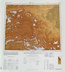 Map including Makit (labeled as MAI-KAI-T'I (MERKET)) and surrounding region from the International Map of the World (AMS, 1966)
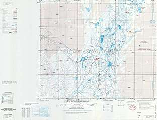 Map including Makit (labeled as MARKIT (MAI-KAI-T'I)) (DMA, 1980)
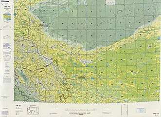 From the Operational Navigation Chart; map including Makit (labeled as Markit (Mai-kai-t’i))(DMA, 1980)[lower-alpha 1]
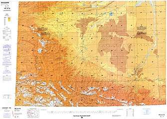 Map including Makit (labeled as Markit (Mai-kai-t'i)) (DMA, 1984)[lower-alpha 2]
See also
Notes
- From map: "The representation of international boundaries is not necessarily authoritative."
- From map: "The representation of international boundaries is not necessarily authoritative"
References
- 麦盖提县历史沿革 [Makit County Historical Evolution]. XZQH.org (in Chinese). 14 November 2014. Retrieved 11 February 2020.
2000年第五次人口普查,麦盖提县常住总人口201810人{...}2003年,麦盖提县总面积11022.53平方千米,{...}2010年第六次人口普查,麦盖提县常住总人口258978人,其中:麦盖提镇40926人,巴扎结米乡23308人,希依提墩乡13646人,央塔克乡31777人,吐曼塔勒乡24599人,尕孜库勒乡26225人,克孜勒阿瓦提乡25841人,库木库萨尔乡13873人,昂格特勒克乡5584人,库尔玛乡14410人,胡杨林场247人,园艺场765人,五一林场1375人,兵团农三师前进水库管理处322人,兵团四十五团30945人,兵团四十六团5135人。
- 人口民族 [Population and Nationalities]. 麦盖提县人民政府 (in Chinese). Archived from the original on 8 May 2018. Retrieved 14 February 2020.
全县共有维吾尔、汉、回、哈萨克等13个民族23万余人,其中:地方人口20.79万人,少数民族人口占总人口的89.6%。
- 1997年麦盖提县行政区划 [1997 Makit County Administrative Divisions]. XZQH.org (in Chinese). 19 November 2010. Retrieved 11 February 2020.
人口18.2万,有维吾尔、汉、回、柯尔克孜等民族,其中维吾尔族占79%,汉族占20%
- James Leibold and Adrian Zenz (23 December 2016). "Beijing's Eyes and Ears Grow Sharper in Xinjiang". Foreign Policy. Retrieved 9 April 2020.
Chen has brought similar tactics to Xinjiang.{...}On the edge of the Taklamakan Desert, for example, Makit county (81 percent Uyghur) is building 61 convenience police stations, including 14 in each of its rural townships.
CS1 maint: uses authors parameter (link) - مەكىت (Variant Non-Roman Script - VS) at GEOnet Names Server, United States National Geospatial-Intelligence Agency
- Zhou Jin (4 December 2019). "China slams passage of Xinjiang-related bill by US House". China Daily. Retrieved 11 February 2020.
Two local farmers walk past a residential house painted with a Chinese flag in celebration of the 70th anniversary of the People's Republic of China in Makit county, Kashgar, Xinjiang Uygur autonomous region, Sept 23, 2019.
- "Intoxicating Makit County in Xinjiang". China Internet Information Center. 7 September 2015. Retrieved 14 February 2020.
Makit County is located in the southwest of China's biggest desert-Taklimakan Desert in Xinjiang Uygur Autonomous Region.
- "Xinjiang's Makit county: Desert turns green". National Forestry and Grassland Administration. 15 July 2019. Retrieved 13 February 2020.
The number of sandy and dusty days in Makit county has dropped from 106 in 2010 to 40 in 2018. Annual rainfall has increased from 53.6 mm in 2010 to 109.6 mm currently.
- Shohret Hoshur; Joshua Lipes (23 August 2018). "Young Son of Uyghurs Held in Xinjiang Political 'Re-Education Camps' Dies in Drowning Incident". Radio Free Asia. Retrieved 13 February 2020.
from Makit (in Chinese, Maigaiti) county, in the XUAR’s Kashgar (Kashi) prefecture,
- Makit (Approved - N) at GEOnet Names Server, United States National Geospatial-Intelligence Agency
- "Introduction to Mekit County". official website of Kashgar Prefecture government. 2005. Archived from the original on 17 October 2007. Retrieved 12 February 2020.
- Markit (Approved - N) at GEOnet Names Server, United States National Geospatial-Intelligence Agency
- Complete Atlas Of The World (3 ed.). Penguin Random House. 2016. p. 238. ISBN 978-1-4654-4401-1 – via Internet Archive.
Markit
- 夏征农; 陈至立, eds. (September 2009). 辞海:第六版彩图本 [Cihai (Sixth Edition in Color)] (in Chinese). 上海. Shanghai: 上海辞书出版社. Shanghai Lexicographical Publishing House. p. 1520. ISBN 9787532628599.
灌溉发达,农产有棉花、玉米、小麦、胡麻、甜瓜、甜菜等。畜牧业亦盛。特产杏干、葡萄干。工业有采煤、农机、建材、服装等。莎巴、麦塔等公路经此。
- 历史文化 [History and Culture]. 麦盖提县人民政府 (in Chinese). Archived from the original on 10 May 2018. Retrieved 14 February 2020.
民国十七年(1928年),建麦盖提县,隶属于喀什噶尔道。
- Farhad Daftary, ed. (2011). A Modern History of the Ismailis: Continuity and Change in a Muslim Community. I.B.Tauris & Co. p. 80. ISBN 9780857723352 – via Google Books.
- Shohret Hoshur; Joshua Lipes (18 April 2014). "Chinese Authorities Mum on Status of Long-Detained Uyghurs". Radio Free Asia. Translated by Mamatjan Juma; Shohret Hoshur. Retrieved 13 February 2020.
A Muslim minority Uyghur in northwestern China’s Xinjiang region and six of his friends have been detained for nearly 20 months over the stabbing death of a Han Chinese prostitute after expressing disgust over the mushrooming of brothels in their township, according to the man’s father.
- Shohret Hoshur, Joshua Lipes (14 May 2020). "Residents of Uyghur-Majority County in Xinjiang Ordered to Report Others Fasting During Ramadan". Radio Free Asia. Translated by Elise Anderson, Alim Seytoff. Retrieved 17 May 2020.CS1 maint: uses authors parameter (link)
- 2018年统计用区划代码和城乡划分代码:麦盖提县 (in Chinese). National Bureau of Statistics of the People's Republic of China. 2018. Retrieved 11 February 2020.
统计用区划代码 名称 653127100000 麦盖提镇 653127112000 巴扎结米镇 653127201000 希依提墩乡 653127202000 央塔克乡 653127203000 吐曼塔勒乡 653127204000 尕孜库勒乡 653127205000 克孜勒阿瓦提乡 653127206000 库木库萨尔乡 653127207000 昂格特勒克乡 653127208000 库尔玛乡 653127400000 胡杨林场 653127401000 园艺场 653127402000 五一林场 653127500000 兵团农三师前进水库管理处 653127505000 兵团四十五团 653127506000 兵团四十六团
- مەكىت ناھىيەسىدىكى يۇرتىغا قايتقان ئوقۇغۇچىلار تەشۋىقات- لېكسىيە پائالىيىتىنى قانات يايدۇردى. China Media Group (in Uyghur). 2 August 2017. Retrieved 14 February 2020.
مەكىت ناھىيەسىنىڭ مەكىت بازىرى
- شېھىتدۆڭ يېزىسى «دولان يەرلىك قوغۇنى» تېرىپ بېيىشقا يۈزلەندى. جۇڭگو قەشقەر تورى (in Uyghur). 10 August 2016. Retrieved 14 February 2020.
مەكىت ناھىيە شېھىتدۆڭ يېزىسى
- Yantak (Approved - N) at GEOnet Names Server, United States National Geospatial-Intelligence Agency
- Tümantal (Approved - N) at GEOnet Names Server, United States National Geospatial-Intelligence Agency
- تۈمەنتال (Variant Non-Roman Script - VS) at GEOnet Names Server, United States National Geospatial-Intelligence Agency
- 3-7 各地、州、市、县(市)分民族人口数 (in Chinese). شىنجاڭ ئۇيغۇر ئاپتونوم رايونى 新疆维吾尔自治区统计局 Statistic Bureau of Xinjiang Uygur Autonomous Region. 15 March 2017. Archived from the original on 11 October 2017. Retrieved 3 September 2017.
- Morris Rossabi, ed. (2004). Governing China’s Multiethnic Frontiers (PDF). University of Washington Press. p. 179. ISBN 0-295-98390-6.
External links
- Sandstorm Affects Traffic during May Day Holiday in Northwest China Counties (Local traffic police direct traffic at major road sections in the county during a sandstorm)
| Wikimedia Commons has media related to Makit County. |