Kashgar Prefecture
Kashgar Prefecture,[2][3][4][5][6][7] also Kashi Prefecture,[8] is located in southwestern Xinjiang, China. It has an area of 112,057 km2 (43,265 sq mi) and 4,499,158 inhabitants at the 2015 census[9] with a population density of 35.5 inhabitants/km2. The capital of the prefecture is the city of Kashgar which has a population 506,640.[10]
Kashgar Prefecture قەشقەر ۋىلايىتى · 喀什地区 Kashij, K'a-shih | |
|---|---|
Prefecture | |
 | |
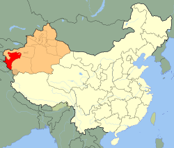 Kashgar Prefecture (red) in Xinjiang (orange) | |
| Country | People's Republic of China |
| Province | Xinjiang |
| Prefecture seat | Kashgar[1] |
| County-level divisions | 1 county-level city, 11 counties[1] |
| Area | |
| • Prefecture | 112,057 km2 (43,265 sq mi) |
| • Urban | 555 km2 (214 sq mi) |
| • Metro | 555 km2 (214 sq mi) |
| Population (2017 census) | |
| • Prefecture | 4,499,158 |
| • Density | 40/km2 (100/sq mi) |
| • Urban | 400,225 |
| • Urban density | 720/km2 (1,900/sq mi) |
| • Metro | 400,225 |
| Ethnic groups | |
| • Major ethnic groups | Uyghur, Han Chinese |
| Time zone | UTC+8 (China Standard) |
| Postal code | 844000 |
| ISO 3166 code | CN-XJ-31 |
| License Plate | 新Q |
| Website | Kashgar Prefecture Government |
| Kashgar Prefecture | |||||||||||||||||||||
|---|---|---|---|---|---|---|---|---|---|---|---|---|---|---|---|---|---|---|---|---|---|
| Uyghur name | |||||||||||||||||||||
| Uyghur | قەشقەر ۋىلايىتى | ||||||||||||||||||||
| |||||||||||||||||||||
| Chinese name | |||||||||||||||||||||
| Simplified Chinese | 喀什地区 | ||||||||||||||||||||
| Traditional Chinese | 喀什地區 | ||||||||||||||||||||
| Hanyu Pinyin | Kāshí Dìqū | ||||||||||||||||||||
| |||||||||||||||||||||
| Alternative Chinese name | |||||||||||||||||||||
| Simplified Chinese | 喀什噶尔地区 | ||||||||||||||||||||
| Traditional Chinese | 喀什噶爾地區 | ||||||||||||||||||||
| Hanyu Pinyin | PRC Standard Mandarin: Kāshígá'ěr Dìqū ROC Standard Mandarin: Kàshígé'ěr Dìqū | ||||||||||||||||||||
| |||||||||||||||||||||
Kashgar Prefecture borders Gorno-Badakhshan Autonomous Oblast of Tajikistan, Badakhshan Province of Afghanistan, Gilgit-Baltistan of Pakistan, as well as Ladakh of India in the far south.
History
After the Communist takeover, Kashgar Prefecture (喀什專區) and Yarkant Prefecture (莎車專區) were established. In June 1956, Yarkant Prefecture was dissolved and made part of Kashgar Prefecture.[11][12]
In January 1979, Kashgar zhuānqū Prefecture (喀什专区) became Kashgar dìqū Prefecture (喀什地区).[11]
In August 1982, Kashgar Prefecture opened a frontier post to exchange goods with Pakistan.[5]:223
In 1992, it was proposed that 500,000 persons displaced by the Three Gorges Dam project, primarily Han Chinese, would be relocated to Kashgar Prefecture. The plans met with widespread criticism in Xinjiang and internationally and were dropped.[13][14]
After a lengthy detention, in December 2009, Alimujiang Yimiti / Alimjan Yimit, Uyghur leader of an unregistered Christian church, was sentenced to fifteen years in jail by the Kashgar Prefecture Intermediate People's Court for "illegally providing state secrets or intelligence to foreign entities". In 2008, his detention was ruled in violation of international standards of due process by the UN Working Group on Arbitrary Detention.[6]
Geography
Most of the prefecture has a cold desert climate.
The second-highest peak on Earth, K2, is located on the China–Pakistan border in southern Kashgar Prefecture[15] in an area claimed by India as part of the Trans-Karakoram Tract.
Administrative divisions
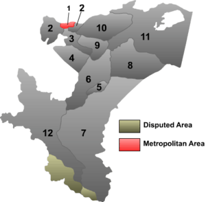 (Outdated map: On October 21, 2014, Aqqash Township (Akekashi) was transferred from Konaxahar (Shufu) County to Kashgar city.[16]) | |||||||||
| # | Name | Uyghur (UEY) | Uyghur Latin (ULY) | Chinese (S)[1][11][17] | Hanyu Pinyin | Population (2010 Census) | Area (km2) | Density (/km2) | |
|---|---|---|---|---|---|---|---|---|---|
| 1 | Kashgar (Kashi) | قەشقەر شەھىرى | Qeshqer Shehiri | 喀什市 | Kāshí Shì | 506,640 | 555 | 912.86 | |
| 2 | Shufu County | كونا شەھەر ناھىيىسى | Konasheher Nahiyisi | 疏附县 | Shūfù Xiàn | 311,960 | 3,483 | 89.56 | |
| 3 | Shule County (Yengixahar County) | يېڭىشەھەر ناھىيىسى | Yéngisheher Nahiyisi | 疏勒县 | Shūlè Xiàn | 312,455 | 2,262 | 138.13 | |
| 4 | Yengisar County | يېڭىسار ناھىيىسى | Yéngisar Nahiyisi | 英吉沙县 | Yīngjíshā Xiàn | 262,067 | 3,421 | 76.60 | |
| 5 | Poskam County (Zepu County) | پوسكام ناھىيىسى | Poskam Nahiyisi | 泽普县 | Zépǔ Xiàn | 206,936 | 1,000 | 206.93 | |
| 6 | Yarkant County (Shache County) | يەكەن ناھىيىسى | Yeken Nahiyisi | 莎车县 | Shāchē Xiàn | 762,385 | 9,037 | 84.36 | |
| 7 | Kargilik County (Yecheng County) | قاغىلىق ناھىيىسى | Qaghiliq Nahiyisi | 叶城县 | Yèchéng Xiàn | 454,328 | 28,929 | 15.70 | |
| 8 | Makit County | مەكىت ناھىيىسى | Mekit Nahiyisi | 麦盖提县 | Màigàití Xiàn | 258,978 | 11,023 | 23.49 | |
| 9 | Yopurga County | يوپۇرغا ناھىيىسى | Yopurgha Nahiyisi | 岳普湖县 | Yuèpǔhú Xiàn | 147,688 | 3,166 | 46.64 | |
| 10 | Payzawat County (Jiashi; Peyziwat) | پەيزاۋات ناھىيىسى | Peyzawat Nahiyisi | 伽师县 | Jiāshī Xiàn | 381,767 | 6,601 | 57.83 | |
| 11 | Maralbexi County (Bachu County) | مارالبېشى ناھىيىسى | Maralbéshi Nahiyisi | 巴楚县 | Bāchǔ Xiàn | 336,274 | 18,491 | 18.18 | |
| 12 | Taxkorgan Tajik Autonomous County | تاشقورغان تاجىك ئاپتونوم ناھىيىسى | Tashqorghan Tajik Aptonom Nahiyisi | 塔什库尔干塔吉克自治县 | Tǎshíkù'ěrgān Tǎjíkè Zìzhìxiàn | 37,843 | 24,089 | 1.57 | |
Demographics
As of the end of 2017, 4,295,200 of the 4,649,700 residents of the prefecture were Uyghur, 288,000 were Han Chinese and 66,500 were from other ethnic groups.[18]
The population of Kashgar Prefecture was 4,499,158 according to the 2015 census. It has a population density of 35.5 inhabitants per km2.[19]
As of 2015, 4,140,255 of the 4,499,158 residents of the prefecture were Uyghur, 292,972 were Han Chinese and 65,931 were from other ethnic groups.[20]
The population growth of Kashgar declined significantly between 2015 and 2018.[21]
As of 1999, 89.37% of the population of Kashgar (Kasi) Prefecture was Uyghur and 9.1% of the population was Han Chinese.[22]
In 1997, the population of Kashgar Prefecture was 3,145,000 with Uyghurs making up 89.4% of the total.[11]
As of 1983-4, Kashgar Prefecture had 6,180 mosques.[4]
In the mid-1980's, there were two million Uyghurs in Kashgar Prefecture and 360,000 Han Chinese.[5]:224
- Population by ethnicity
| Nationality | 2000[23] | 2010[24] | ||
|---|---|---|---|---|
| Population | % | Population | % | |
| Uyghur | 3,042,942 | 89.35% | 3,606,779 | 90.64% |
| Han | 311,770 | 9.15% | 318,281 | 8.00% |
| Tajik | 33,611 | 0.99% | 40,111 | 1.01% |
| Kyrgyz | 5,078 | 0.15% | 5,528 | 0.12% |
| Hui | 5,046 | 0.15% | 4,816 | 0.12% |
| Uzbek | 2,496 | 0.07% | 2,050 | 0.05% |
| Tujia | 829 | 0.02% | 156 | <0.01% |
| Miao | 649 | 0.02% | ||
| Mongol | 634 | 0.02% | 234 | <0.01% |
| Tibetan | 530 | 0.02% | 158 | <0.01% |
| Zhuang | 521 | 0.02% | 234 | <0.01% |
| Kazakhs | 306 | 0.01% | ||
| Others | 1,607 | 0.05% | 638 | 0.02% |
| Total | 3,405,713 | 100% | 3,979,321 | 100% |
Historical maps
Historical English-language maps including modern-day Kashgar Prefecture area:
_p61_PLATE19._SINKIANG_(14597194848).jpg) Map including Kashgar (1917)
Map including Kashgar (1917)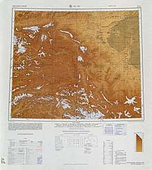 Map including Kashgar and surrounding region from the International Map of the World (AMS, 1966)[lower-alpha 1]
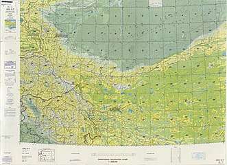 From the Operational Navigation Chart; map including Kashgar Prefecture area (DMA, 1980)[lower-alpha 2]
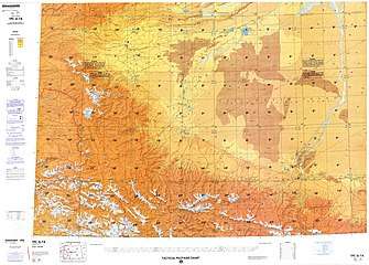 Map including Kashgar Prefecture area (northwest) (DMA, 1984)[lower-alpha 3]
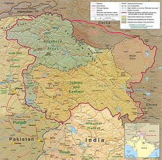 "Territory ceded by Pakistan to China in 1963 and never recognized by India" (Trans-Karakoram Tract in southern Kashgar Prefecture)
Notes
- From map: "DELINEATION OF INTERNATIONAL BOUNDARIES MUST NOT BE CONSIDERED AUTHORITATIVE"
- From map: "The representation of international boundaries is not necessarily authoritative."
- From map: "The representation of international boundaries is not necessarily authoritative"
References
- 喀什概况 [Kashgar Overview] (in Chinese). Kashgar Prefecture People's Government. 26 December 2018. Archived from the original on 24 October 2019. Retrieved 8 April 2020.
喀什地区下辖1个市和11个县,即喀什市、疏附县、疏勒县、英吉沙县、岳普湖县、伽师县、莎车县、泽普县、叶城县、麦盖提县、巴楚县、塔什库尔干塔吉克自治县。喀什市是喀什地区行署所在地,
- "Vocational Education and Training in Xinjiang". State Council of the People's Republic of China (China Daily). 17 August 2019. Archived from the original on 8 April 2020. Retrieved 8 April 2020.
For some time Xinjiang, especially Kashgar Prefecture, Hotan Prefecture, Aksu Prefecture and Kizilsu Kirgiz Autonomous Prefecture in the south, where religious extremism has had a long and widespread presence, suffered badly from frequent acts of terrorism.
- Ministry of Housing and Urban-Rural Development (2010). 建筑抗震设计规范 [GB50011-2010: Code for Seismic Design of Buildings] (in English and Chinese). Beijing: China Architecture & Building Press. p. 203 – via Google Books.
Kashgar Region
- James D. Seymour (1985). China Rights Annals 1 Human Rights Developments in the People's Republic of China from October 1983 through September 1984. M. E. Sharpe. p. 90 – via Internet Archive.
There are 6,180 mosques in Xinjiang's Kashgar Prefecture alone.
- Tiziano Terzani (1985). The Forbidden Door. Asia 2000 Ltd. p. 223, 224 – via Internet Archive.
in August 1982, Kashgar Prefecture opened a frontier post to exchange goods with Pakistan;{...}In Kashgar Prefecture there are two million Uighurs. The Han number only 360,000, but they are the ones in command.
- Bureau of Democracy, Human Rights, and Labor, US Department of State (2011). "International Religious Freedom Report for 2011 China (Includes Tibet, Hong Kong and Macau)". p. 10 – via Internet Archive.CS1 maint: multiple names: authors list (link)
- "Kashgar Jinhuyang Cultural and Tourism Festival kicks off". Tianshannet. October 21, 2016. Archived from the original on 8 August 2018 – via Internet Archive.
Citizens visit Jinhuyang National Forest Park at the opening ceremony of the 9th Kashgar Jinhuyang Cultural and Tourism Festival in Zepu county of Kashgar, northwest China's Xinjiang Uyghur Autonomous Region , Oct .18, 2016.
- Zheng C, Fu J, Li Z, Lin G, Jiang D, Zhou XN (8 December 2018). "Spatiotemporal Variation and Hot Spot Detection of Visceral Leishmaniasis Disease in Kashi Prefecture, China". International Journal of Environmental Research and Public Health. 15 (12): 2784. doi:10.3390/ijerph15122784. PMC 6313707. PMID 30544811.
The results indicated that VL continues to be a serious public health problem in Kashi Prefecture, China, particularly in the north-central region of Jiashi County, which is a relatively high-risk area in which hot spots are distributed.
CS1 maint: uses authors parameter (link) - "Archived copy" 3-7 各地、州、市、县(市)分民族人口数 (in Chinese). Xinjiang Uygur Autonomous Region Bureau of Statistics. Archived from the original on 2017-10-11. Retrieved 2018-04-22.CS1 maint: archived copy as title (link)
- "KĀSHÍ SHÌ (County-level City)". City Population. Archived from the original on 2017-12-03. Retrieved 2017-08-11.
- 喀什地区历史沿革 [Kashgar Prefecture Historical Evolution]. XZQH.org. 14 November 2014. Archived from the original on 7 April 2020. Retrieved 7 April 2020.
2010年第六次人口普查,喀什地区常住总人口3979321人,其中:喀什市506640人,疏附县311960人,疏勒县312455人,英吉沙县262067人,泽普县206936人,莎车县762385人,叶城县454328人,麦盖提县258978人,岳普湖县147688人,伽师县381767人,巴楚县336274人,塔什库尔干塔吉克自治县37843人。
- 泽普概况 (in Chinese). Poskam (Zepu) County People's Government. 17 July 2017. Archived from the original on 26 January 2020. Retrieved 10 April 2020 – via Internet Archive.
1956年6月莎车专区撤销,泽普县划归喀什地区至今。
- Pierre-Antoine Donnet (1990). Tibet: Survival in Question. Translated by Tica Broch. p. 100-101 – via Internet Archive.
Concerning Xinjiang, the China Daily announced on 5 December 1992 that the Peking authorities had chosen the Kashgar region as the new home for almost 500,000 Chinese who will be displaced by the immense Three Gorges Dam project. Once the massive dam on the Yangtze river is operative, a great deal of farmland in central China's Hubei province will be permanently under water. When the final go-ahead is obtained for the project, say the official Chinese daily, 100,000 Chinese farmers will immediately be relocated in Kashgar prefecture, which is expected to absorb 480,000 in the long run. It goes without saying that a population transfer on this scale runs a real risk of further destabilizing an area where, as we have already seen, considerable Chinese Han immigration has taken place since the 1950s.
- James A. Millward (2007). Eurasian Crossroads: A History of Xinjiang. Columbia University Press. p. 309. ISBN 9780231139243. Archived from the original on 2015-11-26. Retrieved 2020-04-08 – via Google Books.
In 1992 the China Daily reported a plan to relocate to Kashgar up to 470,000 people destined to be flooded out of their villages and towns by the Yangzi Three Gorges Dam, then just beginning construction in Central China. After demonstrations by effected villagers, complaints by Bingtuan and Xinjiang officials and an international outcry Beijing officials dropped the idea.
- "Archived copy" 山脉平原. Kashgar Prefecture People's Government. 29 December 2018. Archived from the original on 8 April 2020. Retrieved 8 April 2020.
世界上海拔在8000米以上的14座高峰中,有4座便坐落在喀喇昆仑山脉之中,其中海拔8611米的世界第二高峰——乔戈里峰,是喀喇昆仑山的主峰。
CS1 maint: archived copy as title (link) - "Archived copy" 疏附县历史沿革. XZQH.org. 14 November 2014. Archived from the original on 8 November 2019. Retrieved 5 April 2020.
2014年,自治区政府(新政函[2014]8号)同意撤销乌帕尔乡,设立乌帕尔镇。2014年10月21日,自治区政府(新政函[2014]194号)同意将疏附县阿克喀什乡划归喀什市管辖。
CS1 maint: archived copy as title (link) - "Archived copy" 2019年统计用区划代码和城乡划分代码:喀什地区 (in Chinese). National Bureau of Statistics of the People's Republic of China. 2019. Archived from the original on 7 April 2020. Retrieved 7 April 2020.
统计用区划代码 名称 653101000000 喀什市 653121000000 疏附县 653122000000 疏勒县 653123000000 英吉沙县 653124000000 泽普县 653125000000 莎车县 653126000000 叶城县 653127000000 麦盖提县 653128000000 岳普湖县 653129000000 伽师县 653130000000 巴楚县 653131000000 塔什库尔干塔吉克自治县
CS1 maint: archived copy as title (link) - "Archived copy" 喀什地区2017年国民经济和社会发展统计公报 (in Chinese). Kashgar Prefecture People's Government. Archived from the original on 6 November 2019. Retrieved 7 April 2020.
年末人口总户数119.08万户,总人口464.97万人,比上年增加13.5万人,城镇人口106.50万人,占总人口比重为22.90%。汉族人口28.8万人,占总人口比重为6.2%;维吾尔族人口429.52万人,占总人口比重为92.4%;塔吉克族人口4.35万人,占总人口比重为0.94%;其他民族人口2万人,占总人口比重为0.43%。全年出生率12.83‰,死亡率4.82‰,人口自然增长率8.01‰。
CS1 maint: archived copy as title (link) - "KĀSHÍ DÌQŪ (Prefecture, Xīnjiāng Wéiwú'ĕr Zìzhìqū) Population". City Population. Archived from the original on 2017-02-23. Retrieved 2017-08-11.
- 3-7 各地、州、市、县(市)分民族人口数 (in Chinese). Xinjiang Uygur Autonomous Region Bureau of Statistics. Archived from the original on 2017-10-11. Retrieved 2017-09-03.
- Adrian Zenz (24 November 2019). "China Didn't Want Us to Know. Now Its Own Files Are Doing the Talking". New York Times. Archived from the original on 21 December 2019. Retrieved 24 December 2019.
Official statistics show that the combined net population growth rates of Hotan and Kashgar, two of the largest Uighur regions, dropped by about 84 percent between 2015 and 2018.
- Morris Rossabi, ed. (2004). Governing China’s Multiethnic Frontiers (PDF). University of Washington Press. p. 179. ISBN 0-295-98390-6. Archived (PDF) from the original on 2020-01-07. Retrieved 2020-05-09.
- 2000年人口普查中国民族人口资料. Publishing House of Minority Nationalities. 2003. ISBN 7-105-05425-5.
- Stanley W. Toops (August 2012). Susan M. Walcott; Corey Johnson (eds.). Eurasian Corridors of Interconnection: From the South China to the Caspian Sea. Routledge. pp. 65–66. ISBN 978-1135078751. Archived from the original on 2017-02-23. Retrieved 2017-08-11.
External links
| Wikimedia Commons has media related to Kashgar Prefecture. |