Xinghua, Jiangsu
Xinghua (simplified Chinese: 兴化; traditional Chinese: 興化; pinyin: Xīnghuà) is a county-level city under the administration of Taizhou, Jiangsu province, China. It is located in the central part of Jiangsu Province. It borders the prefecture-level cities of Yancheng to the north and east and Yangzhou to the west.
Xinghua 兴化市 Hinghwa | |
|---|---|
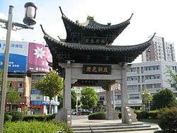 Sipai Tower (四牌楼; 四牌樓), the emblem of the Xinghua Ancient City (兴化古城; 興化古城) | |
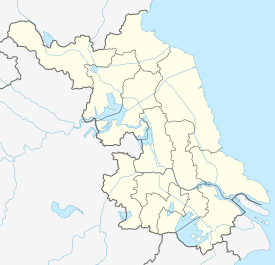 Xinghua Location of the city center in Jiangsu | |
| Coordinates: 32°54′43″N 119°51′09″E[1] | |
| Country | People's Republic of China |
| Province | Jiangsu |
| Prefecture-level city | Taizhou |
| Area | |
| • Total | 2,394.96 km2 (924.70 sq mi) |
| Population | |
| • Total | 1,253,548 |
| • Density | 520/km2 (1,400/sq mi) |
| Time zone | UTC+8 (China Standard) |
| Postal code | 2257XX |
Xinghua's name (兴化) is the abbreviation for "兴盛教化" (xīngshèng jiàohuà) which means "prospering (the Confucian) teaching".[4]
History
In 920, Wu of the Ten Kingdoms separated the northern part of then Hailing county to establish Xinghua county. The land which was used to boil the brine was called Zhaoyuanchang before that.
The county was downgraded as Zhaoyang township in 1135, but was restored in 1149.
In 1987, the county was turned into a city of Yangzhou.
Basically, the area was under the jurisdiction of Yangzhou until 1996, being reassign to Taizhou.
Notable people
- Bi Feiyu, fiction writer
- Fan Zhongyan, politician, was once magistrate in Xinghua[5]
- Hou Yifan, chess grandmaster, born in Xinghua
- Kong Shangren, Qing dynasty dramatist and poet
- Li Jitong (1897–1961), botanist and phytophysiologist[6]
- Zheng Banqiao, Qing dynasty painter
See also
References
- Google (2020-05-08). "Xinghua People's Government" (Map). Google Maps. Google. Retrieved 2020-05-08.
- Taizhou Statistical Yearbook 2012/《泰州统计年鉴2012》.(in Chinese) Accessed 9 July 2014.
- China 2010 Census County-by-county Statistics/《中国2010年人口普查分县资料》.(in Chinese) Accessed 9 July 2014.
- 江苏市县概况 [Overview of Jiangsu's cities and counties] (in Chinese). pp. 394–397. ISBN 978-7-55-373496-5.
- Buckley Ebrey, Patricia (1993). Chinese Civilization a sourcebook. Simon and Schuster. p. 200.
- 30 Years' Review of China's Science & Technology, 1949-1979 (World Scientific Publishing Co., 1981), p. 283.
External links
- (in Chinese) Official Local Government website
- (in English and Chinese) "Illustrated Album of Yangzhou Prefecture", from 1573–1620, has illustrations of Xinghua
Jiangsu topics | |
|---|---|
Nanjing (capital) | |
| General | |
| Geography |
|
| Education | |
| Culture |
|
| Visitor attractions |
|
| |
| Authority control |
|
|---|