Zhangjiagang
Zhangjiagang (simplified Chinese: 张家港; traditional Chinese: 張家港; pinyin: Zhāngjiāgǎng; lit.: 'Zhang family port'), formerly Shazhou County (Chinese: 沙洲县), is a county-level city under the administration of Suzhou, Jiangsu province, China and one of the many ports along the Yangtze river.[2]
Zhangjiagang 张家港市 | |
|---|---|
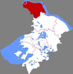 Zhangjiagang in Suzhou | |
 Zhangjiagang Location of the city center in Jiangsu | |
| Coordinates: 31°52′36″N 120°33′22″E | |
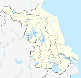
| Country | People's Republic of China |
| Province | Jiangsu |
| Prefecture-level city | Suzhou |
| Divisions | 9 towns: Yangshe, Tangqiao, Jingang, Jinfeng, Leyu, Fenghuang, Nanfeng, Daxin, Changyinsha |
| Area | |
| • Total | 772.4 km2 (298.2 sq mi) |
| Population (2010 census) | |
| • Total | 1,246,762[1] |
| Time zone | UTC+8 (China Standard) |
| Postal code | 215600 |
| Area code(s) | 0512 |
| Vehicle registration plates | 苏EF, 苏EG, 苏EH |
| Website | zjg |
With 1,246,762 inhabitants at the 2010 census,[1] the city is now part of Jiangyin-Zhangjiagang-Jingjiang metropolitan area with 3,526,260 inhabitants. Continued growth will encompass the Yangtze River Delta metropolitan region. It borders the prefecture-level cities of Taizhou and Nantong across the Yangtze River, as well as Wuxi to the west.
History
Toponym
Zhangjiagang is derived from a port in the city, while the port is named after a tributary, Zhangjia. All of them are written as "张家港" in Chinese.
Overview
The area of the city was under jurisdiction of Jiyang township, Piling county during the Han dynasty. It was transferred to Jiyang (then Liangfeng) county which established in 281, while the eastern part of Jiyang was separated as Nansha county in 335. Nansha was merged into Changshu and likewise Liangfeng was merged into Jiangyin. The two counties were demarcated formally by three rivers whose names were Chuan Gang, Jiejing He and South Gudu Gang since 1667. In 1874, a canal called Chang-Tong gang demarcating then Changshu and Nantong was built.
The shoals formed by alluvial deposits in varying of shape and size border the Yangtze River were called shazhou in Chinese. Thus, when the CPC established a new county which located in then Northern Changshu, it was designated as Shazhou. The county was disestablished after the Double Tenth Agreement was signed. In 1962, Changshu and Jiangyin separated their owned parts to establish a county bearing Shazhou. When the county was turn into a county-level city in 1986, it was renamed Zhangjiagang.
Geography
Located 140 kilometers from Shanghai, Zhangjiagang is located along the southern banks of the Yangtze River. The land surrounding Zhangjiagang is extremely fertile, with large spans of rice paddies. In addition, many fish farms are located around the city. Many tributaries of the Yangtze have been contaminated from the construction and operation of chemical factories in the suburb areas.
| Climate data for Zhangjiagang (1986−2005) | |||||||||||||
|---|---|---|---|---|---|---|---|---|---|---|---|---|---|
| Month | Jan | Feb | Mar | Apr | May | Jun | Jul | Aug | Sep | Oct | Nov | Dec | Year |
| Daily mean °C (°F) | 3.5 (38.3) |
5.1 (41.2) |
8.9 (48.0) |
14.8 (58.6) |
20.1 (68.2) |
24.3 (75.7) |
27.9 (82.2) |
27.3 (81.1) |
23.5 (74.3) |
18.0 (64.4) |
12.1 (53.8) |
6.0 (42.8) |
16.0 (60.7) |
| Average precipitation mm (inches) | 57.6 (2.27) |
51.9 (2.04) |
94.9 (3.74) |
73.7 (2.90) |
93.4 (3.68) |
196.1 (7.72) |
167.1 (6.58) |
139.3 (5.48) |
66.8 (2.63) |
54.2 (2.13) |
52.6 (2.07) |
49.5 (1.95) |
1,097.1 (43.19) |
| Source: Zhangjiagang Municipal Chorography (1986−2005) | |||||||||||||
Administration
Zhangjiagang is a special industrial zone. The conceptualization of the port originated with urban city planner Wang Weifeng, PhD (王维锋], in 1986.[3] Till 1993, it was a small village with no more than fields, fish farms and a small fishing port. In 1993, the area was declared an experimental industrial zone and opened up to international trade.[4]
The region is divided into eight towns:[5][6]
- Yangshe (杨舍, the seat of city)
- Daxin (大新)
- Fenghuang (凤凰)
- Jinfeng (锦丰)
- Jingang (金港)
- Leyu (乐余)
- Nanfeng (南丰)
- Tangqiao (塘桥)
Besides, Changyinsha Modern Agriculture Demonstration Zone (常沙阴现代农业示范园区), Shuangshandao Island Tourist Resort (双山岛旅游度假区), (张家港经济技术开发区), (张家港保税区), (张家港市市稻麦良种场), (张家港市畜禽良种场), and (张家港市冶金工业园) are regarded as township level administrations with actual jurisdictions.
References
- "China: Jiāngsū (Prefectures, Cities, Districts and Counties) - Population Statistics, Charts and Map". www.citypopulation.de.
- Guide to port entry. London: World ports guide / IHS. 1 January 2018.
- Wang, Weifeng (1986). "Zhangjiagang and Regional Economic Development". Journal of Nanjing University. 1: 185, 186, 187.
- "Zhangjiagang - a brief history". www.jiangsu.net. Jiangsu government. Retrieved 4 September 2018.
- Zhangjiagang Yearbook (2016). 2016. pp. 29–54. ISBN 978-7514420494.
External links
Jiangsu topics | |
|---|---|
Nanjing (capital) | |
| General | |
| Geography |
|
| Education | |
| Culture |
|
| Visitor attractions |
|
| |