Shigatse
Shigatse, officially known as Xigazê[1][2] (Tibetan: གཞིས་ཀ་རྩེ་ ; Chinese: 日喀则; pinyin: Rìkāzé, is a prefecture-level city of the Tibet Autonomous Region of the People's Republic of China, with an area of 182,000 km2 (70,271 sq mi). It is located within the historical Tsang province of Tibet.
Xigazê 日喀则市 · གཞིས་ཀ་རྩེ་གྲོང་ཁྱེར། Shigatse | |
|---|---|
 | |
| Nickname(s): Gateway to Everest | |
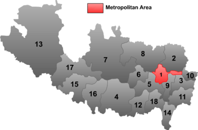
 Shigatse City (orange) in Tibet Autonomous Region (light-orange) | |
| Country | People's Republic of China |
| Autonomous region | Tibet |
| County-level divisions |
|
| Municipal seat | Samzhubzê District |
| Area | |
| • Total | 182,000 km2 (70,000 sq mi) |
| Population | |
| • Total | 703,292 |
| • Density | 3.9/km2 (10/sq mi) |
| Time zone | UTC+8 (China Standard) |
| ISO 3166 code | CN-XZ-02 |
| Shigatse | |||||||||||||||||
|---|---|---|---|---|---|---|---|---|---|---|---|---|---|---|---|---|---|
| Chinese name | |||||||||||||||||
| Simplified Chinese | 日喀则 | ||||||||||||||||
| Traditional Chinese | 日喀則 | ||||||||||||||||
| Hanyu Pinyin | Rìkāzé | ||||||||||||||||
| |||||||||||||||||
| Tibetan name | |||||||||||||||||
| Tibetan | གཞིས་ཀ་རྩེ་ | ||||||||||||||||
| |||||||||||||||||
Overview
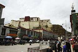
The administrative center of the prefecture-level city is the Samzhubzê District. It is roughly equivalent to the ancient Shigatse urban center, the second-largest city in Tibet, located about 280 km (170 mi) southwest of Lhasa and home to the Tashilhunpo Monastery, traditionally the seat of the Panchen Lama.[3]
Some of the towns in the prefecture are: Gyantse (Gyantse County), Tingri (Tingri County), and Nyalam (Nyalam County).
On 11 July 2014 Shigatse Prefecture was upgraded into a prefecture-level city (the same status as Lhasa).[4]
Transport
Rail
The Lhasa–Xigazê Railway connects Xigazê Railway Station with Lhasa and further connects with Qinghai via Qinghai–Tibet Railway. It takes about 3 hours to travel between Lhasa and Shigatse by train. It is possible to get back to Lhasa within the same day by train.[5]
Air
Shigatse Peace Airport began operations on 30 October 2010 after an Airbus A319 landed safely, making it Tibet's fifth commercial airport. It is located 43 kilometres from Samzhubzê District at Jangdam Township at an elevation of 3,782 metres. The airport will be capable of supporting 230,000 passengers annually by 2020.[6]
Road
China National Highway 318 and China National Highway 219 are the main roads in and out of Shigatse.
Counties
| Map | # | Name | Simplified Chinese | Hanyu Pinyin | Tibetan | Wylie | Population (2010 Census) | Area (km²) | Density (/km²) |
|---|---|---|---|---|---|---|---|---|---|
 | |||||||||
| City proper | |||||||||
| 1 | Samzhubzê District | 桑珠孜区 | Sāngzhūzī Qū | བསམ་འགྲུབ་རྩེ་ཆུས། | bsam 'grub rtse chus | 120,374 | 3,654 | 32.94 | |
| Rural | |||||||||
| 2 | Namling County | 南木林县 | Nánmùlín Xiàn | རྣམ་གླིང་རྫོང་། | rnam gling rdzong | 74,930 | 8,113 | 9.23 | |
| 3 | Gyantse County | 江孜县 | Jiāngzī Xiàn | རྒྱལ་རྩེ་རྫོང་། | rgyal rtse rdzong | 63,503 | 3,859 | 16.45 | |
| 4 | Tingri County | 定日县 | Dìngrì Xiàn | དིང་རི་རྫོང་། | ding ri rdzong | 50,818 | 13,859 | 3.66 | |
| 5 | Sa'gya County | 萨迦县 | Sàjiā Xiàn | ས་སྐྱ་རྫོང་། | sa skya rdzong | 47,304 | 7,510 | 6.29 | |
| 6 | Lhatse County | 拉孜县 | Lāzī Xiàn | ལྷ་རྩེ་རྫོང་། | lha rtse rdzong | 49,286 | 4,505 | 10.94 | |
| 7 | Ngamring County | 昂仁县 | Ángrén Xiàn | ངམ་རིང་རྫོང་། | ngam ring rdzong | 51,472 | 20,105 | 2.56 | |
| 8 | Xaitongmoin County | 谢通门县 | Xiètōngmén Xiàn | བཞད་མཐོང་སྨོན་རྫོང་། | bzhad mthong smon rdzong | 42,280 | 13,960 | 3.02 | |
| 9 | Bainang County | 白朗县 | Báilǎng Xiàn | པ་སྣམ་རྫོང་། | pa snam rdzong | 42,551 | 2,806 | 15.16 | |
| 10 | Rinbung County | 仁布县 | Rénbù Xiàn | རིན་སྤུངས་རྫོང་། | rin spungs rdzong | 27,826 | 2,123 | 13.10 | |
| 11 | Kangmar County | 康马县 | Kāngmǎ Xiàn | ཁང་དམར་རྫོང་། | khang dmar rdzong | 20,522 | 6,165 | 3.32 | |
| 12 | Dinggyê County | 定结县 | Dìngjié Xiàn | གཏིང་སྐྱེས་རྫོང་། | gding skyes rdzong | 20,319 | 5,816 | 3.49 | |
| 13 | Zhongba County | 仲巴县 | Zhòngbā Xiàn | འབྲོང་པ་རྫོང་། | 'brong pa rdzong | 22,147 | 43,594 | 0.50 | |
| 14 | Yadong County | 亚东县 | Yàdōng Xiàn | གྲོ་མོ་རྫོང་། | gro mo rdzong | 12,920 | 4,306 | 3.00 | |
| 15 | Gyirong County | 吉隆县 | Jílóng Xiàn | སྐྱིད་གྲོང་རྫོང་། | skyid grong rdzong | 14,972 | 9,009 | 1.66 | |
| 16 | Nyalam County | 聂拉木县 | Nièlāmù Xiàn | གཉའ་ལམ་རྫོང་། | gnya' lam rdzong | 17,568 | 7,903 | 2.22 | |
| 17 | Saga County | 萨嘎县 | Sàgā Xiàn | ས་དགའ་རྫོང་། | sa dga' rdzong | 14,036 | 12,411 | 1.13 | |
| 18 | Kamba County | 岗巴县 | Gǎngbā Xiàn | གམ་པ་རྫོང་། | gam pa rdzong | 10,464 | 3,936 | 2.65 | |
Climate
Shigatse has an elevation-influenced humid continental climate (Köppen climate classification: Dwb).
| Climate data for Shigatse | |||||||||||||
|---|---|---|---|---|---|---|---|---|---|---|---|---|---|
| Month | Jan | Feb | Mar | Apr | May | Jun | Jul | Aug | Sep | Oct | Nov | Dec | Year |
| Average high °C (°F) | 5.6 (42.1) |
7.9 (46.2) |
10.9 (51.6) |
15.2 (59.4) |
18.9 (66.0) |
22.2 (72.0) |
20.8 (69.4) |
19.7 (67.5) |
18.5 (65.3) |
15.1 (59.2) |
10.3 (50.5) |
6.8 (44.2) |
14.3 (57.8) |
| Daily mean °C (°F) | −3.7 (25.3) |
−0.8 (30.6) |
2.8 (37.0) |
7.3 (45.1) |
11.0 (51.8) |
14.9 (58.8) |
14.7 (58.5) |
13.9 (57.0) |
12.1 (53.8) |
6.9 (44.4) |
1.0 (33.8) |
−2.7 (27.1) |
6.5 (43.6) |
| Average low °C (°F) | −13.0 (8.6) |
−9.4 (15.1) |
−5.3 (22.5) |
−0.7 (30.7) |
3.2 (37.8) |
7.6 (45.7) |
8.7 (47.7) |
8.1 (46.6) |
5.7 (42.3) |
−1.2 (29.8) |
−8.3 (17.1) |
−12.2 (10.0) |
−1.4 (29.5) |
| Average precipitation mm (inches) | 0 (0) |
0 (0) |
2 (0.1) |
3 (0.1) |
15 (0.6) |
60 (2.4) |
129 (5.1) |
146 (5.7) |
58 (2.3) |
7 (0.3) |
2 (0.1) |
0 (0) |
422 (16.7) |
| Source: Climate-Data.org [7] | |||||||||||||
Gallery
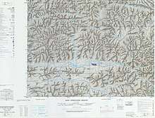
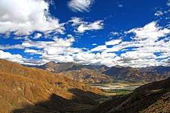 Mountains in Shigatse Prefecture
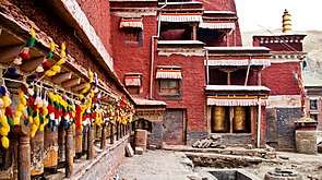
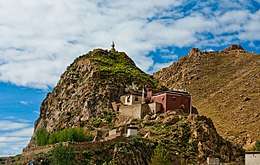 Monastery along the road from Shigatse to Mount Everest
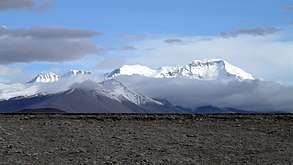
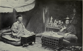 Photo of the Shigatse abbot taken around 1910
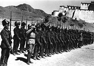 Tibetan Army about 1938 with the dzong or fort in the background- note British-style uniforms and British made rifles
See also
References
- Powers, John (2016). The Buddha party : how the People's Republic of China works to define and control Tibetan Buddhism. New York, NY: Oxford University Press. pp. Appendix B, page 16. ISBN 9780199358182. OCLC 967694121.
- 国家测绘局地名研究所 (1997). 中国地名录 [Gazetteer of China]. Beijing: SinoMaps Press. p. 311. ISBN 7-5031-1718-4.
- Mapping the Tibetan World. Yukyasu Osada, Gavin Allwright, and Atushi Kanamaru. 1st edition 200. Reprint 2004. Kotan Books, Japan, pp. 109, 113.
- Li, Zhe. 西藏日喀则成为中国最年轻地级市. 中国网. Archived from the original on 14 July 2014. Retrieved 13 July 2014.
- "Shigatse Travel" ChinaTour.net Archived 2015-08-16 at Wikiwix Accessed 2013-4-21
- "Archived copy". Archived from the original on 2010-11-07. Retrieved 2010-11-01.CS1 maint: archived copy as title (link)
- "Climate: Shigatse - Climate-Data.org". Archived from the original on January 22, 2018. Retrieved January 21, 2018.
Further reading
External links

- . Encyclopædia Britannica (11th ed.). 1911.
|
| ||||||||||||||||||
| Authority control |
|
|---|