Prouzel
| Prouzel | |
|---|---|
| Commune | |
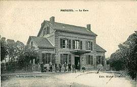 The railway station in Prouzel | |
 Prouzel Location within Hauts-de-France region  Prouzel | |
| Coordinates: 49°48′59″N 2°12′15″E / 49.8164°N 2.2042°ECoordinates: 49°48′59″N 2°12′15″E / 49.8164°N 2.2042°E | |
| Country | France |
| Region | Hauts-de-France |
| Department | Somme |
| Arrondissement | Amiens |
| Canton | Ailly-sur-Noye |
| Intercommunality | CC Somme Sud-Ouest |
| Government | |
| • Mayor (2001–2008) | Audouin De l'Epine |
| Area1 | 5.19 km2 (2.00 sq mi) |
| Population (2006)2 | 492 |
| • Density | 95/km2 (250/sq mi) |
| Time zone | UTC+1 (CET) |
| • Summer (DST) | UTC+2 (CEST) |
| INSEE/Postal code | 80643 /80160 |
| Elevation |
38–129 m (125–423 ft) (avg. 42 m or 138 ft) |
|
1 French Land Register data, which excludes lakes, ponds, glaciers > 1 km2 (0.386 sq mi or 247 acres) and river estuaries. 2 Population without double counting: residents of multiple communes (e.g., students and military personnel) only counted once. | |
Prouzel is a commune in the Somme department in Hauts-de-France in northern France.
Geography
Prouzel is situated on the D8b road, some 7 miles (11 km) southwest of Amiens, near the banks of the river Selle.
Population
| 1962 | 1968 | 1975 | 1982 | 1990 | 1999 | 2006 |
|---|---|---|---|---|---|---|
| 306 | 352 | 384 | 399 | 502 | 503 | align=center |
| Starting in 1962: Population without duplicates | ||||||
Places of interest
- sixteenth-century church of Notre-Dame de la Nativité, with baptismal fonts from the twelfth century
- 17th-century château
- The ‘Coulée verte’ (en: ’Green Trail’). When the local railway closed in 1939, the derelict line was eventually converted into a pleasant nature trail.
- 18th-century pigeon house
Personalities
Gabriel Ferez, a student from Prouzel, was murdered in south London in June 2008.[1]
See also
References
External links
| Wikimedia Commons has media related to Prouzel. |
- Prouzel on the Quid website (in French)
This article is issued from
Wikipedia.
The text is licensed under Creative Commons - Attribution - Sharealike.
Additional terms may apply for the media files.