Gamaches
| Gamaches | ||
|---|---|---|
| Commune | ||
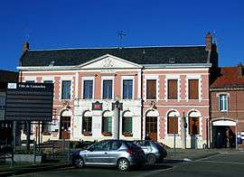 The town hall in Gamaches | ||
| ||
 Gamaches Location within Hauts-de-France region  Gamaches | ||
| Coordinates: 49°59′15″N 1°33′29″E / 49.9875°N 1.5581°ECoordinates: 49°59′15″N 1°33′29″E / 49.9875°N 1.5581°E | ||
| Country | France | |
| Region | Hauts-de-France | |
| Department | Somme | |
| Arrondissement | Abbeville | |
| Canton | Gamaches | |
| Intercommunality | CC Villes Sœurs | |
| Government | ||
| • Mayor (2001–2008) | Jacques Pecquery | |
| Area1 | 9.92 km2 (3.83 sq mi) | |
| Population (2006)2 | 2,992 | |
| • Density | 300/km2 (780/sq mi) | |
| Time zone | UTC+1 (CET) | |
| • Summer (DST) | UTC+2 (CEST) | |
| INSEE/Postal code | 80373 /80220 | |
| Elevation |
19–126 m (62–413 ft) (avg. 32 m or 105 ft) | |
|
1 French Land Register data, which excludes lakes, ponds, glaciers > 1 km2 (0.386 sq mi or 247 acres) and river estuaries. 2 Population without double counting: residents of multiple communes (e.g., students and military personnel) only counted once. | ||

Gamaches is a commune in the Somme department in Hauts-de-France in northern France.
Geography
Gamaches is situated on the D1015, on the banks of the Bresle River, the border with Seine-Maritime, some 18 miles (29 km) southwest of Abbeville.
Huge lakes to the west of the town are a paradise for naturalists, anglers and water sports enthusiasts.
History
- 1471 Louis XI and the Burgundians wage war in and around the town. A year or so later, Charles the Bold ravaged Picardy in the continuing battle with Burgundy. The plague decimated not only the troops but also the local populace.
- Gamache has, for a long time, been linked with the manufacture of glass.
Population
| Year | 1962 | 1968 | 1975 | 1982 | 1990 | 1999 | 2006 |
|---|---|---|---|---|---|---|---|
| Population | 3194 | 3216 | 3467 | 3270 | 3099 | 2949 | 2992 |
| From the year 1962 on: No double counting—residents of multiple communes (e.g. students and military personnel) are counted only once. | |||||||
Places of interest
- The war memorial
- The thirteenth century church of Saint-Pierre and Saint-Paul, with its flamboyant gothic tower, is the result of successive architectural influences.
- The old railway line, opened in 1872 and closed in 1993 [1]
- The lakes
See also
References
External links
| Wikimedia Commons has media related to Gamaches. |
- War memorial (in French)
- Agence Régionale du Patrimoine de Picardie (in French)
- S.A.Saint-Martin Glass Bottle factory (in French)
This article is issued from
Wikipedia.
The text is licensed under Creative Commons - Attribution - Sharealike.
Additional terms may apply for the media files.