Méneslies
| Méneslies | |
|---|---|
| Commune | |
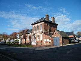 The town hall and school in Méneslies | |
 Méneslies Location within Hauts-de-France region  Méneslies | |
| Coordinates: 50°03′32″N 1°29′50″E / 50.0589°N 1.4972°E / 50.0589; 1.4972Coordinates: 50°03′32″N 1°29′50″E / 50.0589°N 1.4972°E / 50.0589; 1.4972 | |
| Country | France |
| Region | Hauts-de-France |
| Department | Somme |
| Arrondissement | Abbeville |
| Canton | Friville-Escarbotin |
| Intercommunality | CC Vimeu |
| Government | |
| • Mayor (2001–2008) | Michel Dizambourg |
| Area1 | 4.04 km2 (1.56 sq mi) |
| Population (2006)2 | 314 |
| • Density | 78/km2 (200/sq mi) |
| Time zone | UTC+1 (CET) |
| • Summer (DST) | UTC+2 (CEST) |
| INSEE/Postal code | 80527 /80520 |
| Elevation |
55–124 m (180–407 ft) (avg. 90 m or 300 ft) |
|
1 French Land Register data, which excludes lakes, ponds, glaciers > 1 km2 (0.386 sq mi or 247 acres) and river estuaries. 2 Population without double counting: residents of multiple communes (e.g., students and military personnel) only counted once. | |
Méneslies is a commune in the Somme department in Hauts-de-France in northern France.
Geography
The commune is situated on the D19 road, some 15 miles (24 km) southwest of Abbeville.
Population
| 1962 | 1968 | 1975 | 1982 | 1990 | 1999 | 2006 |
|---|---|---|---|---|---|---|
| 360 | 372 | 369 | 346 | 327 | 310 | 314 |
| Starting in 1962: Population without duplicates | ||||||
See also
References
External links
| Wikimedia Commons has media related to Méneslies. |
- Méneslies on the Quid website (in French)
This article is issued from
Wikipedia.
The text is licensed under Creative Commons - Attribution - Sharealike.
Additional terms may apply for the media files.