Saint-Fuscien
| Saint-Fuscien | ||
|---|---|---|
| Commune | ||
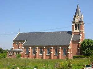 The church in 2010 | ||
| ||
 Saint-Fuscien Location within Hauts-de-France region  Saint-Fuscien | ||
| Coordinates: 49°50′18″N 2°18′56″E / 49.8383°N 2.3156°ECoordinates: 49°50′18″N 2°18′56″E / 49.8383°N 2.3156°E | ||
| Country | France | |
| Region | Hauts-de-France | |
| Department | Somme | |
| Arrondissement | Amiens | |
| Canton | Amiens-6 | |
| Intercommunality | Amiens Métropole | |
| Government | ||
| • Mayor (2008–2014) | Dominique de Witasse Thézy | |
| Area1 | 9.92 km2 (3.83 sq mi) | |
| Population (2006)2 | 911 | |
| • Density | 92/km2 (240/sq mi) | |
| Time zone | UTC+1 (CET) | |
| • Summer (DST) | UTC+2 (CEST) | |
| INSEE/Postal code | 80702 /80680 | |
| Elevation |
38–113 m (125–371 ft) (avg. 108 m or 354 ft) | |
|
1 French Land Register data, which excludes lakes, ponds, glaciers > 1 km2 (0.386 sq mi or 247 acres) and river estuaries. 2 Population without double counting: residents of multiple communes (e.g., students and military personnel) only counted once. | ||
Saint-Fuscien is a commune in the Somme department in Hauts-de-France in northern France.
The name of the commune in Picard is Saint-Fuschien.
Geography
The commune is situated some 5 km (3 mi) south of Amiens, on the D7 road.
History
The commune's name is derived from Saint Fuscian (Fuscien, Fulcian) (3rd century), who is said to have been buried in the area, along with Saints Gentian and Victoricus (Victorice).
Population
| 1962 | 1968 | 1975 | 1982 | 1990 | 1999 | 2006 |
|---|---|---|---|---|---|---|
| 363 | 431 | 687 | 1026 | 1031 | 966 | 911 |
| Starting in 1962: Population without duplicates | ||||||
Places of interest
- The church:
- Burnt down by arsonists in February 2005.
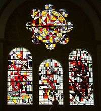
Stained glass by Alain Mongrenier
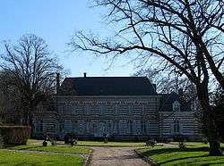
- Ruins of Saint-Fuscien abbey
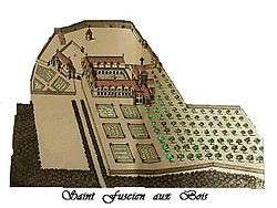
Abbey of Saint-Fuscien
from Monasticon Gallicanum
from Monasticon Gallicanum
Coat of arms (Blason)
| Image | |
|---|---|
 |
Saint-Fuscien
D'azur aux troés keuvrons d'érgint aveuc troés étoéles d'or. |
See also
References
| Wikimedia Commons has media related to Saint-Fuscien. |
This article is issued from
Wikipedia.
The text is licensed under Creative Commons - Attribution - Sharealike.
Additional terms may apply for the media files.