Béthencourt-sur-Mer
| Béthencourt-sur-Mer | |
|---|---|
| Commune | |
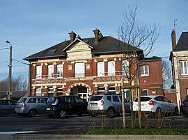 The town hall and school in Béthencourt-sur-Mer | |
 Béthencourt-sur-Mer Location within Hauts-de-France region  Béthencourt-sur-Mer | |
| Coordinates: 50°04′43″N 1°30′15″E / 50.0786°N 1.5042°ECoordinates: 50°04′43″N 1°30′15″E / 50.0786°N 1.5042°E | |
| Country | France |
| Region | Hauts-de-France |
| Department | Somme |
| Arrondissement | Abbeville |
| Canton | Friville-Escarbotin |
| Intercommunality | CC Vimeu |
| Government | |
| • Mayor (2001–2008) | Denis Durot |
| Area1 | 2.95 km2 (1.14 sq mi) |
| Population (2010)2 | 1,042 |
| • Density | 350/km2 (910/sq mi) |
| Time zone | UTC+1 (CET) |
| • Summer (DST) | UTC+2 (CEST) |
| INSEE/Postal code | 80096 /80130 |
| Elevation |
75–119 m (246–390 ft) (avg. 97 m or 318 ft) |
|
1 French Land Register data, which excludes lakes, ponds, glaciers > 1 km2 (0.386 sq mi or 247 acres) and river estuaries. 2 Population without double counting: residents of multiple communes (e.g., students and military personnel) only counted once. | |
Béthencourt-sur-Mer (Picard: Bétincourt-su-Mér) is a commune in the Somme department in Hauts-de-France in northern France.
Geography
The commune is situated on the D19 and D229 road junction, some 3 miles (5 km) from the seaside and 18 miles (29 km) west of Abbeville.
Population
| Year | 1962 | 1968 | 1975 | 1982 | 1990 | 1999 | 2006 |
|---|---|---|---|---|---|---|---|
| Population | 1002 | 1120 | 1163 | 1074 | 1024 | 997 | 1040 |
| From the year 1962 on: No double counting—residents of multiple communes (e.g. students and military personnel) are counted only once. | |||||||
See also
References
External links
| Wikimedia Commons has media related to Béthencourt-sur-Mer. |
- Béthencourt-sur-Mer on the Quid site (French)
- Béthencourt-sur-Mer on the map of France (French)
This article is issued from
Wikipedia.
The text is licensed under Creative Commons - Attribution - Sharealike.
Additional terms may apply for the media files.