Andechy
| Andechy | |
|---|---|
| Commune | |
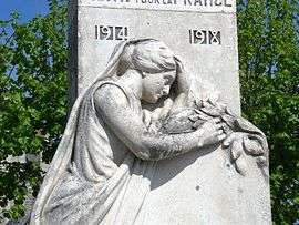 The monument to the dead, at Andechy | |
 Andechy Location within Hauts-de-France region  Andechy | |
| Coordinates: 49°42′56″N 2°42′36″E / 49.7156°N 2.71°ECoordinates: 49°42′56″N 2°42′36″E / 49.7156°N 2.71°E | |
| Country | France |
| Region | Hauts-de-France |
| Department | Somme |
| Arrondissement | Montdidier |
| Canton | Roye |
| Intercommunality | CC Grand Roye |
| Government | |
| • Mayor (2014-2020) | Sébastien Carpentier |
| Area1 | 7.77 km2 (3.00 sq mi) |
| Population (2014)2 | 257 |
| • Density | 33/km2 (86/sq mi) |
| Time zone | UTC+1 (CET) |
| • Summer (DST) | UTC+2 (CEST) |
| INSEE/Postal code | 80023 /80700 |
| Elevation |
58–104 m (190–341 ft) (avg. 103 m or 338 ft) |
|
1 French Land Register data, which excludes lakes, ponds, glaciers > 1 km2 (0.386 sq mi or 247 acres) and river estuaries. 2 Population without double counting: residents of multiple communes (e.g., students and military personnel) only counted once. | |
Andechy is a commune in the Somme department in Hauts-de-France in northern France.
Geography
The commune is situated 30 miles (48 km) southeast of Amiens at the junction of the D54 and D139, 3 miles (5 km) from the junction of the A1 autoroute du Nord.
History
The village was completely destroyed during World War I.
Population
| Year | 1962 | 1968 | 1975 | 1982 | 1990 | 1999 | 2006 |
|---|---|---|---|---|---|---|---|
| Population | 173 | 186 | 151 | 173 | 211 | 212 | 239 |
| From the year 1962 on: No double counting—residents of multiple communes (e.g. students and military personnel) are counted only once. | |||||||
See also
References
External links
| Wikimedia Commons has media related to Andechy. |
(All French language)
This article is issued from
Wikipedia.
The text is licensed under Creative Commons - Attribution - Sharealike.
Additional terms may apply for the media files.