Remiencourt
| Remiencourt | |
|---|---|
| Commune | |
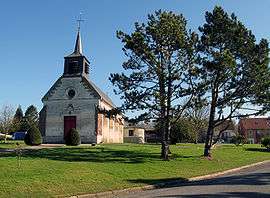 The church in Remiencourt | |
 Remiencourt Location within Hauts-de-France region  Remiencourt | |
| Coordinates: 49°47′01″N 2°23′01″E / 49.7836°N 2.3836°E / 49.7836; 2.3836Coordinates: 49°47′01″N 2°23′01″E / 49.7836°N 2.3836°E / 49.7836; 2.3836 | |
| Country | France |
| Region | Hauts-de-France |
| Department | Somme |
| Arrondissement | Amiens |
| Canton | Ailly-sur-Noye |
| Intercommunality | Amiens Métropole |
| Government | |
| • Mayor (2001–2008) | Hugues De Francqueville |
| Area1 | 4.82 km2 (1.86 sq mi) |
| Population (2006)2 | 185 |
| • Density | 38/km2 (99/sq mi) |
| Time zone | UTC+1 (CET) |
| • Summer (DST) | UTC+2 (CEST) |
| INSEE/Postal code | 80668 /80250 |
| Elevation |
37–114 m (121–374 ft) (avg. 53 m or 174 ft) |
|
1 French Land Register data, which excludes lakes, ponds, glaciers > 1 km2 (0.386 sq mi or 247 acres) and river estuaries. 2 Population without double counting: residents of multiple communes (e.g., students and military personnel) only counted once. | |
Remiencourt is a commune in the Somme department in Hauts-de-France in northern France.
Geography
Remiencourt is situated 8 miles (13 km) south of Amiens, on the D90 road and by the banks of the river Noye.
Places of interest
- The church
See also
References
External links
| Wikimedia Commons has media related to Remiencourt. |
- Remiencourton on the Quid website (in French)
This article is issued from
Wikipedia.
The text is licensed under Creative Commons - Attribution - Sharealike.
Additional terms may apply for the media files.