Bouttencourt
| Bouttencourt | ||
|---|---|---|
| Commune | ||
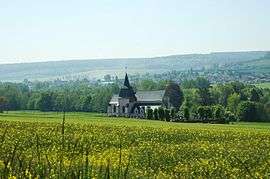 The church in Bouttencourt | ||
| ||
 Bouttencourt Location within Hauts-de-France region  Bouttencourt | ||
| Coordinates: 49°56′10″N 1°37′53″E / 49.9361°N 1.6314°ECoordinates: 49°56′10″N 1°37′53″E / 49.9361°N 1.6314°E | ||
| Country | France | |
| Region | Hauts-de-France | |
| Department | Somme | |
| Arrondissement | Abbeville | |
| Canton | Gamaches | |
| Intercommunality | CC Aumale - Blangy-sur-Bresle | |
| Government | ||
| • Mayor (2001–2008) | Jean-Pascal Sellier | |
| Area1 | 7.73 km2 (2.98 sq mi) | |
| Population (2010)2 | 1,017 | |
| • Density | 130/km2 (340/sq mi) | |
| Time zone | UTC+1 (CET) | |
| • Summer (DST) | UTC+2 (CEST) | |
| INSEE/Postal code | 80126 /80220 | |
| Elevation |
31–161 m (102–528 ft) (avg. 19 m or 62 ft) | |
|
1 French Land Register data, which excludes lakes, ponds, glaciers > 1 km2 (0.386 sq mi or 247 acres) and river estuaries. 2 Population without double counting: residents of multiple communes (e.g., students and military personnel) only counted once. | ||

Bouttencourt is a commune in the Somme department in Hauts-de-France in northern France.
Geography
Bouttencourt is situated on the D928 and D1015 crossroads, by the banks of the river Bresle, the border with the Seine-Maritime département, some 18 miles (29 km) southwest of Abbeville.
Population
| Year | 1946 | 1954 | 1962 | 1968 | 1975 | 1982 | 1990 | 1999 | 2006 |
|---|---|---|---|---|---|---|---|---|---|
| Population | 755 | 754 | 777 | 741 | 887 | 928 | 941 | 1015 | 1064 |
| From the year 1962 on: No double counting—residents of multiple communes (e.g. students and military personnel) are counted only once. | |||||||||
See also
References
External links
| Wikimedia Commons has media related to Bouttencourt. |
- Bouttencourt on the Quid website (in French)
This article is issued from
Wikipedia.
The text is licensed under Creative Commons - Attribution - Sharealike.
Additional terms may apply for the media files.