Breilly
| Breilly | ||
|---|---|---|
| Commune | ||
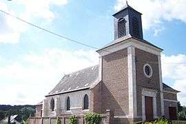 The church in Breilly | ||
| ||
 Breilly Location within Hauts-de-France region  Breilly | ||
| Coordinates: 49°56′07″N 2°10′51″E / 49.9353°N 2.1808°ECoordinates: 49°56′07″N 2°10′51″E / 49.9353°N 2.1808°E | ||
| Country | France | |
| Region | Hauts-de-France | |
| Department | Somme | |
| Arrondissement | Amiens | |
| Canton | Ailly-sur-Somme | |
| Intercommunality | CC Nièvre et Somme | |
| Government | ||
| • Mayor (mars2008–mars2014) | Etienne Pecquet | |
| Area1 | 5.73 km2 (2.21 sq mi) | |
| Population (2010)2 | 469 | |
| • Density | 82/km2 (210/sq mi) | |
| Time zone | UTC+1 (CET) | |
| • Summer (DST) | UTC+2 (CEST) | |
| INSEE/Postal code | 80137 /80470 | |
| Elevation |
12–101 m (39–331 ft) (avg. 17 m or 56 ft) | |
|
1 French Land Register data, which excludes lakes, ponds, glaciers > 1 km2 (0.386 sq mi or 247 acres) and river estuaries. 2 Population without double counting: residents of multiple communes (e.g., students and military personnel) only counted once. | ||

Breilly is a commune in the Somme department in Hauts-de-France in northern France.
Geography
Breilly is situated on the D1235 road, by the banks of the river Somme, some 4 miles (6 km) northwest of Amiens.
Places of interest
- St Sulpice church
- St Louis chapel
- war memorial
- The "château de Breilly" (private location - ruins)
Population
| Year | 1962 | 1968 | 1975 | 1982 | 1990 | 1999 | 2006 |
|---|---|---|---|---|---|---|---|
| Population | 389 | 403 | 419 | 434 | 434 | 465 | 474 |
| From the year 1962 on: No double counting—residents of multiple communes (e.g. students and military personnel) are counted only once. | |||||||
See also
References
External links

- Breilly on the Quid website
- Breilly(Unofficial town website)
This article is issued from
Wikipedia.
The text is licensed under Creative Commons - Attribution - Sharealike.
Additional terms may apply for the media files.