Oissy
| Oissy | |
|---|---|
| Commune | |
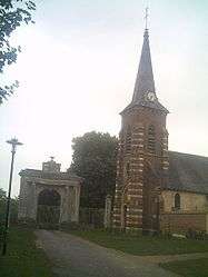 The church in Oissy | |
 Oissy Location within Hauts-de-France region  Oissy | |
| Coordinates: 49°54′20″N 2°03′05″E / 49.9056°N 2.0514°ECoordinates: 49°54′20″N 2°03′05″E / 49.9056°N 2.0514°E | |
| Country | France |
| Region | Hauts-de-France |
| Department | Somme |
| Arrondissement | Amiens |
| Canton | Ailly-sur-Somme |
| Intercommunality | CC Somme Sud-Ouest |
| Government | |
| • Mayor (2001–2008) | Thierry Langlet |
| Area1 | 5.52 km2 (2.13 sq mi) |
| Population (2006)2 | 235 |
| • Density | 43/km2 (110/sq mi) |
| Time zone | UTC+1 (CET) |
| • Summer (DST) | UTC+2 (CEST) |
| INSEE/Postal code | 80607 /80540 |
| Elevation |
37–119 m (121–390 ft) (avg. 25 m or 82 ft) |
|
1 French Land Register data, which excludes lakes, ponds, glaciers > 1 km2 (0.386 sq mi or 247 acres) and river estuaries. 2 Population without double counting: residents of multiple communes (e.g., students and military personnel) only counted once. | |
Oissy is a commune in the Somme department in Hauts-de-France in northern France.
Geography
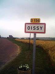
Oissy is situated on the D156 road, some 13 miles (21 km) west of Amiens.
Population
| 1962 | 1968 | 1975 | 1982 | 1990 | 1999 | 2006 |
|---|---|---|---|---|---|---|
| 86 | 99 | 109 | 182 | 211 | 213 | 235 |
| Starting in 1962: Population without duplicates | ||||||
Places of interest
- The 17th/18th-century château. Built by François Trudaine as part of a great estate sold to the nation in 1795. Much of the grounds still exist. The entrance and the ground-floor were severely damaged in a fire in 1946. Constructed in red brick and sandstone on a rectangular plan, it has a mansard style roof. The water feature is in its original shape. The château and its domain constitute an interesting example of châteaux of the late 17th century in the region.
- The church
See also
References
External links
| Wikimedia Commons has media related to Oissy. |
- Oissy on the Quid website (in French)
This article is issued from
Wikipedia.
The text is licensed under Creative Commons - Attribution - Sharealike.
Additional terms may apply for the media files.