Ault, Somme
| Ault | ||
|---|---|---|
| Commune | ||
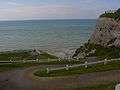
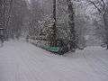
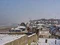
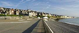 The beach at Ault | ||
| ||
 Ault Location within Hauts-de-France region  Ault | ||
| Coordinates: 50°06′07″N 1°26′58″E / 50.1019°N 1.4494°ECoordinates: 50°06′07″N 1°26′58″E / 50.1019°N 1.4494°E | ||
| Country | France | |
| Region | Hauts-de-France | |
| Department | Somme | |
| Arrondissement | Abbeville | |
| Canton | Friville-Escarbotin | |
| Intercommunality | CC Villes Sœurs | |
| Government | ||
| • Mayor (2014-2020) | Marthe Sueur | |
| Area1 | 5.99 km2 (2.31 sq mi) | |
| Population (2015)2 | 1,516 | |
| • Density | 250/km2 (660/sq mi) | |
| Time zone | UTC+1 (CET) | |
| • Summer (DST) | UTC+2 (CEST) | |
| INSEE/Postal code | 80039 /80460 | |
| Elevation |
0–107 m (0–351 ft) (avg. 86 m or 282 ft) | |
|
1 French Land Register data, which excludes lakes, ponds, glaciers > 1 km2 (0.386 sq mi or 247 acres) and river estuaries. 2 Population without double counting: residents of multiple communes (e.g., students and military personnel) only counted once. | ||

Ault is a commune in the Somme department in Hauts-de-France in northern France.
Geography
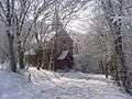
Situated on the English Channel, on the D19 road, 20 miles (32 km) west of Abbeville, in the southwest of the department, Ault possesses chalk cliffs overlooking a beach of pebbles (and sand at low tide). To the south of the town is a large wooded area, the ‘Bois de Cise’, in a valley that leads on to the coast. To the north, the cliffs descend to the level of the beach at Onival. The area around the town, the 'hâble d’Ault' was mostly tidal marshland that has been reclaimed from the sea. Cattle, sheep and game are raised here.
Railways
Ault had a station on the standard gauge Woincourt to Onival line, which closed to passengers in May 1939, but saw much use during World War II to move materials for the Atlantic Wall. During the war, a metre gauge line was laid alongside the road from Lanchères, on the CFBS, to Ault. This line was dismantled after the war.[1]
Population
| Year | 1962 | 1968 | 1975 | 1982 | 1990 | 1999 | 2006 | 2015 |
|---|---|---|---|---|---|---|---|---|
| Population | 1996 | 2014 | 2192 | 2058 | 2054 | 2070 | 1941 | 1516 |
| From the year 1962 on: No double counting—residents of multiple communes (e.g. students and military personnel) are counted only once. | ||||||||
Places of interest
- The 15th / sixteenth century church of Saint-Pierre,
- The war memorial, designed by Paul Landowski.
- Two chapels, at Onival and Bois de Cise dating from the nineteenth century.
- Several ancient village houses.
- The lighthouse, with its lantern over 106 metres above sea-level.
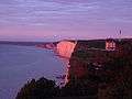
- The cliffs
- The beaches of Ault and Bois de Cise..
- The ‘hâble d'Ault’, with signed pathways.
Sea defences
The town has paid a heavy price defending itself against the sea, which is constantly washing away the beach, cliffs and public spaces, such as the car parks and gardens. The problem is ongoing. A "balcony on the sea", a huge concrete construction has been built but the risks remain. Signs of wear of the dyke under the casino have been noted.
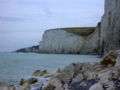 The cliffs
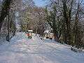
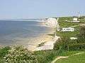 Bois de Cise and cliffs
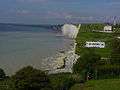


See also
References
External links
| Wikimedia Commons has media related to Ault. |
- Mayor’s website (in French)
- Ault on the Insee website (in French)
- Ault on the Quid website (in French)