Grébault-Mesnil
| Grébault-Mesnil | ||
|---|---|---|
| Commune | ||
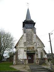 The church in Grébault-Mesnil | ||
| ||
 Grébault-Mesnil Location within Hauts-de-France region  Grébault-Mesnil | ||
| Coordinates: 50°01′34″N 1°43′17″E / 50.0261°N 1.7214°ECoordinates: 50°01′34″N 1°43′17″E / 50.0261°N 1.7214°E | ||
| Country | France | |
| Region | Hauts-de-France | |
| Department | Somme | |
| Arrondissement | Abbeville | |
| Canton | Abbeville-2 | |
| Intercommunality | CC Vimeu | |
| Government | ||
| • Mayor (2008–2014) | Sadia Cavillon | |
| Area1 | 2.58 km2 (1.00 sq mi) | |
| Population (2006)2 | 175 | |
| • Density | 68/km2 (180/sq mi) | |
| Time zone | UTC+1 (CET) | |
| • Summer (DST) | UTC+2 (CEST) | |
| INSEE/Postal code | 80388 /80140 | |
| Elevation |
93–113 m (305–371 ft) (avg. 94 m or 308 ft) | |
|
1 French Land Register data, which excludes lakes, ponds, glaciers > 1 km2 (0.386 sq mi or 247 acres) and river estuaries. 2 Population without double counting: residents of multiple communes (e.g., students and military personnel) only counted once. | ||

Grébault-Mesnil is a commune in the Somme department in Hauts-de-France in northern France.
Geography
The communes is situated on the D86 road, some 8 miles (12 km) southwest of Abbeville.
Population
| Year | 1962 | 1968 | 1975 | 1982 | 1990 | 1999 | 2006 |
|---|---|---|---|---|---|---|---|
| Population | 155 | 159 | 152 | 128 | 109 | 113 | 175 |
| From the year 1962 on: No double counting—residents of multiple communes (e.g. students and military personnel) are counted only once. | |||||||
See also
References
External links
| Wikimedia Commons has media related to Grébault-Mesnil. |
- Grébault-Mesnil on the Quid website (in French)
This article is issued from
Wikipedia.
The text is licensed under Creative Commons - Attribution - Sharealike.
Additional terms may apply for the media files.