Wiry-au-Mont
| Wiry-au-Mont | |
|---|---|
| Commune | |
%2C_France.JPG) The church in Wiry | |
 Wiry-au-Mont Location within Hauts-de-France region  Wiry-au-Mont | |
| Coordinates: 49°57′49″N 1°50′26″E / 49.9636°N 1.8406°ECoordinates: 49°57′49″N 1°50′26″E / 49.9636°N 1.8406°E | |
| Country | France |
| Region | Hauts-de-France |
| Department | Somme |
| Arrondissement | Abbeville |
| Canton | Gamaches |
| Intercommunality | CA Baie de Somme |
| Government | |
| • Mayor (2014-2020) | Marcel Régnier |
| Area1 | 4.81 km2 (1.86 sq mi) |
| Population (2014)2 | 123 |
| • Density | 26/km2 (66/sq mi) |
| Time zone | UTC+1 (CET) |
| • Summer (DST) | UTC+2 (CEST) |
| INSEE/Postal code | 80825 /80270 |
| Elevation |
45–119 m (148–390 ft) (avg. 109 m or 358 ft) |
|
1 French Land Register data, which excludes lakes, ponds, glaciers > 1 km2 (0.386 sq mi or 247 acres) and river estuaries. 2 Population without double counting: residents of multiple communes (e.g., students and military personnel) only counted once. | |
Wiry-au-Mont is a commune in the Somme department in Hauts-de-France in northern France.
Geography
The commune is situated 16 km (10 miles) south of Abbeville, on the D936 road.
Population
| Year | 1962 | 1968 | 1975 | 1982 | 1990 | 1999 | 2006 |
|---|---|---|---|---|---|---|---|
| Population | 116 | 116 | 118 | 111 | 92 | 96 | 114 |
| From the year 1962 on: No double counting—residents of multiple communes (e.g. students and military personnel) are counted only once. | |||||||
Places of interest
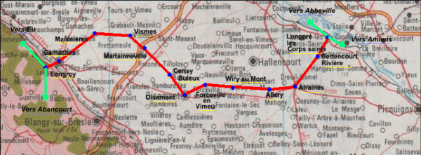
The railway was opened on 9 May 1872 and was used principally from freight, although some passengers were carried.
It was finally closed on 10 November 1993. It served the following communes:
Longpré-les-Corps-Saints / Bettencourt-Rivière / Airaines / Allery / Wiry-au-Mont / Forceville / Oisemont / Cerisy-Buleux / Martainneville / Saint-Maxent / Vismes-au-Val / Maisnières / Longroy and Gamaches
See also
References
- ↑ Source:Mémorial morts pour la France (80): nombres de morts Archived 3 July 2008 at the Wayback Machine.(in French)
- ↑ Source:Fcvnet "Longpré-les-Corps-Saints - Longroy-Gamaches"(in French)
External links
| Wikimedia Commons has media related to Wiry-au-Mont. |
- Communauté de communes website (in French)
- Wiry-au-Mont on the Quid website (in French)
This article is issued from
Wikipedia.
The text is licensed under Creative Commons - Attribution - Sharealike.
Additional terms may apply for the media files.