Cantigny, Somme
| Cantigny | |
|---|---|
| Commune | |
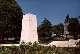 The Cantigny Memorial | |
 Cantigny Location within Hauts-de-France region  Cantigny | |
| Coordinates: 49°39′51″N 2°29′35″E / 49.6642°N 2.4931°ECoordinates: 49°39′51″N 2°29′35″E / 49.6642°N 2.4931°E | |
| Country | France |
| Region | Hauts-de-France |
| Department | Somme |
| Arrondissement | Montdidier |
| Canton | Roye |
| Intercommunality | CC Grand Roye |
| Government | |
| • Mayor (2001–2008) | M. Benoît De Weirdt |
| Area1 | 4.03 km2 (1.56 sq mi) |
| Population (2006)2 | 123 |
| • Density | 31/km2 (79/sq mi) |
| Time zone | UTC+1 (CET) |
| • Summer (DST) | UTC+2 (CEST) |
| INSEE/Postal code | 80170 /80500 |
| Elevation |
64–112 m (210–367 ft) (avg. 104 m or 341 ft) |
|
1 French Land Register data, which excludes lakes, ponds, glaciers > 1 km2 (0.386 sq mi or 247 acres) and river estuaries. 2 Population without double counting: residents of multiple communes (e.g., students and military personnel) only counted once. | |
Cantigny is a commune in the Somme department in Hauts-de-France in northern France.
History
During World War I, a battle liberated the town from German forces. Major General Robert Lee Bullard commanded the US First Division in the United States' first victory of the war. About 10 years later, Colonel Robert R. McCormick named his estate in Illinois after the town.
Geography
Cantigny is situated on the D28 road, some 20 miles (32 km) southeast of Amiens.
Population
| Year | 1962 | 1968 | 1975 | 1982 | 1990 | 1999 | 2006 |
|---|---|---|---|---|---|---|---|
| Population | 110 | 117 | 116 | 123 | 131 | 124 | 123 |
| From the year 1962 on: No double counting—residents of multiple communes (e.g. students and military personnel) are counted only once. | |||||||
See also
References
External links
| Wikimedia Commons has media related to Cantigny. |
- Cantigny on the Quid website (in French)
- Battle of Cantigny at the American Expeditionary Force website
This article is issued from
Wikipedia.
The text is licensed under Creative Commons - Attribution - Sharealike.
Additional terms may apply for the media files.