Le Cardonnois
| Le Cardonnois | |
|---|---|
| Commune | |
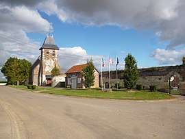 The church and town hall in Le Cardonnois | |
 Le Cardonnois Location within Hauts-de-France region  Le Cardonnois | |
| Coordinates: 49°37′42″N 2°28′51″E / 49.6283°N 2.4808°ECoordinates: 49°37′42″N 2°28′51″E / 49.6283°N 2.4808°E | |
| Country | France |
| Region | Hauts-de-France |
| Department | Somme |
| Arrondissement | Montdidier |
| Canton | Roye |
| Intercommunality | CC Grand Roye |
| Government | |
| • Mayor (2001–2008) | Gérard Guyon |
| Area1 | 2.37 km2 (0.92 sq mi) |
| Population (2006)2 | 75 |
| • Density | 32/km2 (82/sq mi) |
| Time zone | UTC+1 (CET) |
| • Summer (DST) | UTC+2 (CEST) |
| INSEE/Postal code | 80174 /80500 |
| Elevation |
72–135 m (236–443 ft) (avg. 116 m or 381 ft) |
|
1 French Land Register data, which excludes lakes, ponds, glaciers > 1 km2 (0.386 sq mi or 247 acres) and river estuaries. 2 Population without double counting: residents of multiple communes (e.g., students and military personnel) only counted once. | |
Le Cardonnois is a commune in the Somme department in Hauts-de-France in northern France.
Geography
The commune is situated on the D188 road, some 30 miles (48 km) south-southeast of Amiens.
Population
| Year | 1962 | 1968 | 1975 | 1982 | 1990 | 1999 | 2006 |
|---|---|---|---|---|---|---|---|
| Population | 13 | 32 | 38 | 37 | 41 | 50 | 75 |
| From the year 1962 on: No double counting—residents of multiple communes (e.g. students and military personnel) are counted only once. | |||||||
See also
References
External links
| Wikimedia Commons has media related to Le Cardonnois. |
- Le Cardonnois on Quid (in French)
This article is issued from
Wikipedia.
The text is licensed under Creative Commons - Attribution - Sharealike.
Additional terms may apply for the media files.