Thieulloy-la-Ville
| Thieulloy-la-Ville | |
|---|---|
| Commune | |
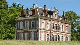 The chateau in Thieulloy-la-Ville | |
 Thieulloy-la-Ville Location within Hauts-de-France region  Thieulloy-la-Ville | |
| Coordinates: 49°44′52″N 1°55′52″E / 49.7478°N 1.9311°ECoordinates: 49°44′52″N 1°55′52″E / 49.7478°N 1.9311°E | |
| Country | France |
| Region | Hauts-de-France |
| Department | Somme |
| Arrondissement | Amiens |
| Canton | Poix-de-Picardie |
| Intercommunality | CC Somme Sud-Ouest |
| Government | |
| • Mayor (2008–2014) | Bernard Morain |
| Area1 | 3.28 km2 (1.27 sq mi) |
| Population (2006)2 | 100 |
| • Density | 30/km2 (79/sq mi) |
| Time zone | UTC+1 (CET) |
| • Summer (DST) | UTC+2 (CEST) |
| INSEE/Postal code | 80755 /80290 |
| Elevation |
130–189 m (427–620 ft) (avg. 180 m or 590 ft) |
|
1 French Land Register data, which excludes lakes, ponds, glaciers > 1 km2 (0.386 sq mi or 247 acres) and river estuaries. 2 Population without double counting: residents of multiple communes (e.g., students and military personnel) only counted once. | |
Thieulloy-la-Ville is a commune in the Somme department in Hauts-de-France in northern France.
Geography
The commune is situated 21 miles (34 km) southwest of Amiens, on the D919 road
Population
| 1962 | 1968 | 1975 | 1982 | 1990 | 1999 | 2006 |
|---|---|---|---|---|---|---|
| 117 | 123 | 96 | 80 | 92 | 94 | 100 |
| Starting in 1962: Population without duplicates | ||||||
See also
References
External links
| Wikimedia Commons has media related to Thieulloy-la-Ville. |
- Official commune website (in French)
- Thieulloy-la-Ville on the Quid website (in French)
This article is issued from
Wikipedia.
The text is licensed under Creative Commons - Attribution - Sharealike.
Additional terms may apply for the media files.