Fins, Somme
| Fins | |
|---|---|
| Commune | |
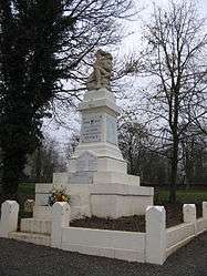 The war memorial in Fins | |
 Fins Location within Hauts-de-France region  Fins | |
| Coordinates: 50°02′08″N 3°03′10″E / 50.0356°N 3.0528°ECoordinates: 50°02′08″N 3°03′10″E / 50.0356°N 3.0528°E | |
| Country | France |
| Region | Hauts-de-France |
| Department | Somme |
| Arrondissement | Péronne |
| Canton | Péronne |
| Intercommunality | Haute Somme |
| Government | |
| • Mayor (2001–2008) | Daniel Decodts |
| Area1 | 6.87 km2 (2.65 sq mi) |
| Population (2006)2 | 273 |
| • Density | 40/km2 (100/sq mi) |
| Time zone | UTC+1 (CET) |
| • Summer (DST) | UTC+2 (CEST) |
| INSEE/Postal code | 80312 /80360 |
| Elevation |
93–138 m (305–453 ft) (avg. 103 m or 338 ft) |
|
1 French Land Register data, which excludes lakes, ponds, glaciers > 1 km2 (0.386 sq mi or 247 acres) and river estuaries. 2 Population without double counting: residents of multiple communes (e.g., students and military personnel) only counted once. | |
Fins is a commune in the Somme department in Hauts-de-France in northern France.
Geography
Fins is situated on the D917 and D58 crossroads, near the border with the Pas-de-Calais département, some 20 miles (32 km) northwest of Saint Quentin.
Population
| Year | 1962 | 1968 | 1975 | 1982 | 1990 | 1999 | 2006 |
|---|---|---|---|---|---|---|---|
| Population | 293 | 313 | 296 | 258 | 243 | 257 | 273 |
| From the year 1962 on: No double counting—residents of multiple communes (e.g. students and military personnel) are counted only once. | |||||||
See also
References
External links
| Wikimedia Commons has media related to Fins. |
- Fins on the Quid website (in French)
This article is issued from
Wikipedia.
The text is licensed under Creative Commons - Attribution - Sharealike.
Additional terms may apply for the media files.