Moyenneville, Somme
| Moyenneville | ||
|---|---|---|
| Commune | ||
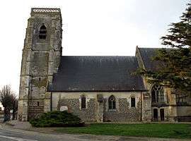 The church in Moyenneville | ||
| ||
 Moyenneville Location within Hauts-de-France region  Moyenneville | ||
| Coordinates: 50°04′22″N 1°45′02″E / 50.0728°N 1.7506°ECoordinates: 50°04′22″N 1°45′02″E / 50.0728°N 1.7506°E | ||
| Country | France | |
| Region | Hauts-de-France | |
| Department | Somme | |
| Arrondissement | Abbeville | |
| Canton | Abbeville-2 | |
| Intercommunality | CC Vimeu | |
| Government | ||
| • Mayor (2001–2008) | Dominique Vanhoegaerden | |
| Area1 | 14.12 km2 (5.45 sq mi) | |
| Population (2006)2 | 670 | |
| • Density | 47/km2 (120/sq mi) | |
| Time zone | UTC+1 (CET) | |
| • Summer (DST) | UTC+2 (CEST) | |
| INSEE/Postal code | 80578 /80870 | |
| Elevation |
17–106 m (56–348 ft) (avg. 114 m or 374 ft) | |
|
1 French Land Register data, which excludes lakes, ponds, glaciers > 1 km2 (0.386 sq mi or 247 acres) and river estuaries. 2 Population without double counting: residents of multiple communes (e.g., students and military personnel) only counted once. | ||

Moyenneville (Picard: Moéyénneville) is a commune in the Somme department in Hauts-de-France in northern France.
Geography
Moyenneville is situated at the D22 and D73 crossroads, some 5 miles (8 km) southwest of Abbeville.
Population
| 1962 | 1968 | 1975 | 1982 | 1990 | 1999 | 2006 |
|---|---|---|---|---|---|---|
| 612 | 618 | 603 | 557 | 565 | 626 | 670 |
| Starting in 1962: Population without duplicates | ||||||
See also
References
External links
| Wikimedia Commons has media related to Moyenneville (Somme). |
- Moyenneville on the Quid website (in French)
This article is issued from
Wikipedia.
The text is licensed under Creative Commons - Attribution - Sharealike.
Additional terms may apply for the media files.