Lucheux
| Lucheux | ||
|---|---|---|
| Commune | ||
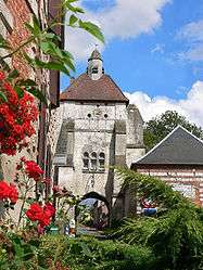 The belfry of Lucheux is a former city gate tower | ||
| ||
 Lucheux Location within Hauts-de-France region  Lucheux | ||
| Coordinates: 50°12′00″N 2°25′00″E / 50.2°N 2.4167°ECoordinates: 50°12′00″N 2°25′00″E / 50.2°N 2.4167°E | ||
| Country | France | |
| Region | Hauts-de-France | |
| Department | Somme | |
| Arrondissement | Amiens | |
| Canton | Doullens | |
| Intercommunality | CC Territoire Nord Picardie | |
| Government | ||
| • Mayor (2001–2008) | Pierre Trzcialkowski | |
| Area1 | 27.65 km2 (10.68 sq mi) | |
| Population (2006)2 | 648 | |
| • Density | 23/km2 (61/sq mi) | |
| Time zone | UTC+1 (CET) | |
| • Summer (DST) | UTC+2 (CEST) | |
| INSEE/Postal code | 80495 /80600 | |
| Elevation |
70–174 m (230–571 ft) (avg. 87 m or 285 ft) | |
|
1 French Land Register data, which excludes lakes, ponds, glaciers > 1 km2 (0.386 sq mi or 247 acres) and river estuaries. 2 Population without double counting: residents of multiple communes (e.g., students and military personnel) only counted once. | ||
.svg.png)
Lucheux is a commune in the Somme department in Hauts-de-France in northern France.
Geography
Lucheux is situated on the D5 road, some 18 miles (29 km) southwest of Arras, near the border with the neighbouring département of the Pas-de-Calais.
Population
| 1962 | 1968 | 1975 | 1982 | 1990 | 1999 | 2006 |
|---|---|---|---|---|---|---|
| 522 | 543 | 513 | 553 | 607 | 568 | 648 |
| Starting in 1962: Population without duplicates | ||||||
History
The château was taken by the Protestants under Captain Cocqueville in 1568 during the Wars of Religion. Laid to siege and taken again in 1595 during the same wars, this time by the Spanish under Hernando Teillo de Porto Carrer.
Places of interest
Lucheux is a medieval town with many remarkable monuments:
- The belfry, listed as an historic monument in 1896,
- The fifteenth-century château.
Dominating the town on the road leading north to Avesnes-le-Comte), it presents an abrupt wall into the valley and the forest with the ruins of some round towers. The moat surrounding the fortress is preserved and can be visited. Some parts are overgrown and inaccessible.[1] The vestiges of the round towers are hidden on their exterior face, but the entrance is well restored. The interior allows an understanding of the dimensions of the dwelling space available to the lord of the manor, with its walls and double bays of the Great Hall, below which one can see the
moat and a preserved section of the keep or ‘donjon’.
- The church, dating from the twelfth century.
- An unusual hollow tree, known as the ‘marriage’ tree
- Many restored typical Picardy houses.
_1.jpg) Château walls and moat
Château walls and moat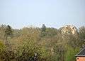 Ruins of the donjon
_tombe_DONNETTE-HURET.jpg) Cemetery
Cemetery Sundial
People
- Saint Leger, who was killed in the forest of Sarcing in 678.
See also
References
- ↑ Noted in this state in the spring of 2007
External links
| Wikimedia Commons has media related to Lucheux. |
- Lucheux on the Quid website (in French)
- Site du Syndicat Mixte des Vals d'Authie, Nièvre et Somme (in French)