Blangy-sous-Poix
| Blangy-sous-Poix | |
|---|---|
| Commune | |
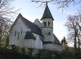 The church in Blangy-sous-Poix | |
 Blangy-sous-Poix Location within Hauts-de-France region  Blangy-sous-Poix | |
| Coordinates: 49°46′02″N 2°00′11″E / 49.7672°N 2.0031°ECoordinates: 49°46′02″N 2°00′11″E / 49.7672°N 2.0031°E | |
| Country | France |
| Region | Hauts-de-France |
| Department | Somme |
| Arrondissement | Amiens |
| Canton | Poix-de-Picardie |
| Intercommunality | CC Somme Sud-Ouest |
| Government | |
| • Mayor (2001–2008) | Alain Lesur |
| Area1 | 8.01 km2 (3.09 sq mi) |
| Population (2006)2 | 185 |
| • Density | 23/km2 (60/sq mi) |
| Time zone | UTC+1 (CET) |
| • Summer (DST) | UTC+2 (CEST) |
| INSEE/Postal code | 80106 /80290 |
| Elevation |
85–189 m (279–620 ft) (avg. 99 m or 325 ft) |
|
1 French Land Register data, which excludes lakes, ponds, glaciers > 1 km2 (0.386 sq mi or 247 acres) and river estuaries. 2 Population without double counting: residents of multiple communes (e.g., students and military personnel) only counted once. | |
Blangy-sous-Poix is a commune in the Somme department in Hauts-de-France in northern France.
Geography
The commune is situated 23 miles (37 km) southwest of Amiens on the D262 road.
Population
| Year | 1962 | 1968 | 1975 | 1982 | 1990 | 1999 | 2006 |
|---|---|---|---|---|---|---|---|
| Population | 132 | 159 | 146 | 160 | 141 | 158 | 163 |
| From the year 1962 on: No double counting—residents of multiple communes (e.g. students and military personnel) are counted only once. | |||||||
See also
References
External links
| Wikimedia Commons has media related to Blangy-sous-Poix. |
- Blangy-sous-Poix on the Quid site (French)
This article is issued from
Wikipedia.
The text is licensed under Creative Commons - Attribution - Sharealike.
Additional terms may apply for the media files.