Aizecourt-le-Haut
| Aizecourt-le-Haut | |
|---|---|
| Commune | |
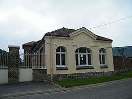 The town hall of Aizecourt-le-Haut | |
 Aizecourt-le-Haut Location within Hauts-de-France region  Aizecourt-le-Haut | |
| Coordinates: 49°57′51″N 2°59′03″E / 49.9642°N 2.9842°ECoordinates: 49°57′51″N 2°59′03″E / 49.9642°N 2.9842°E | |
| Country | France |
| Region | Hauts-de-France |
| Department | Somme |
| Arrondissement | Péronne |
| Canton | Péronne |
| Intercommunality | Haute Somme |
| Government | |
| • Mayor (2014-2020) | Jean-Marie Deleau |
| Area1 | 3.65 km2 (1.41 sq mi) |
| Population (2014)2 | 71 |
| • Density | 19/km2 (50/sq mi) |
| Time zone | UTC+1 (CET) |
| • Summer (DST) | UTC+2 (CEST) |
| INSEE/Postal code | 80015 /80200 |
| Elevation |
78–147 m (256–482 ft) (avg. 120 m or 390 ft) |
|
1 French Land Register data, which excludes lakes, ponds, glaciers > 1 km2 (0.386 sq mi or 247 acres) and river estuaries. 2 Population without double counting: residents of multiple communes (e.g., students and military personnel) only counted once. | |
Aizecourt-le-Haut is a commune in the Somme department in Hauts-de-France in northern France.
Geography
The commune is on the D917 departmental road, 35 km (22 mi) northeast of Saint-Quentin.
Demography
| Year | 1962 | 1968 | 1975 | 1982 | 1990 | 1999 | 2006 |
|---|---|---|---|---|---|---|---|
| Population | 58 | 69 | 72 | 54 | 80 | 100 | 95 |
| From the year 1962 on: No double counting—residents of multiple communes (e.g. students and military personnel) are counted only once. | |||||||
See also
References
External links
| Wikimedia Commons has media related to Aizecourt-le-Haut. |
(All French language)
This article is issued from
Wikipedia.
The text is licensed under Creative Commons - Attribution - Sharealike.
Additional terms may apply for the media files.