Bosquel
| Bosquel | |
|---|---|
| Commune | |
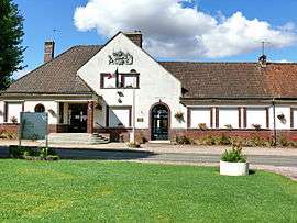 The town hall and school of Le Bosquel | |
 Bosquel Location within Hauts-de-France region  Bosquel | |
| Coordinates: 49°44′23″N 2°13′45″E / 49.7397°N 2.2293°ECoordinates: 49°44′23″N 2°13′45″E / 49.7397°N 2.2293°E | |
| Country | France |
| Region | Hauts-de-France |
| Department | Somme |
| Arrondissement | Amiens |
| Canton | Ailly-sur-Noye |
| Intercommunality | CC Somme Sud-Ouest |
| Government | |
| • Mayor (2001–2008) | Gérard Glorieux |
| Area1 | 9.48 km2 (3.66 sq mi) |
| Population (2010)2 | 295 |
| • Density | 31/km2 (81/sq mi) |
| Time zone | UTC+1 (CET) |
| • Summer (DST) | UTC+2 (CEST) |
| INSEE/Postal code | 80114 /80160 |
| Elevation |
74–157 m (243–515 ft) (avg. 137 m or 449 ft) |
|
1 French Land Register data, which excludes lakes, ponds, glaciers > 1 km2 (0.386 sq mi or 247 acres) and river estuaries. 2 Population without double counting: residents of multiple communes (e.g., students and military personnel) only counted once. | |
Bosquel is a commune in the Somme department in Hauts-de-France in northern France.
Geography
Bosquel is situated on the D920 road, less than a mile from the A16 autoroute, some 14 miles (23 km) south of Amiens.
Population
| Year | 1962 | 1968 | 1975 | 1982 | 1990 | 1999 | 2006 |
|---|---|---|---|---|---|---|---|
| Population | 250 | 296 | 254 | 280 | 303 | 293 | 303 |
| From the year 1962 on: No double counting—residents of multiple communes (e.g. students and military personnel) are counted only once. | |||||||
See also
References
External links
| Wikimedia Commons has media related to Bosquel. |
- Bosquel on the Quid site (French)
This article is issued from
Wikipedia.
The text is licensed under Creative Commons - Attribution - Sharealike.
Additional terms may apply for the media files.