Pierregot
| Pierregot | |
|---|---|
| Commune | |
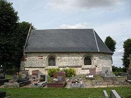 The chapel of Notre-Dame O Pie, in Pierregot | |
 Pierregot Location within Hauts-de-France region  Pierregot | |
| Coordinates: 50°00′09″N 2°22′49″E / 50.0025°N 2.3803°ECoordinates: 50°00′09″N 2°22′49″E / 50.0025°N 2.3803°E | |
| Country | France |
| Region | Hauts-de-France |
| Department | Somme |
| Arrondissement | Amiens |
| Canton | Corbie |
| Intercommunality | CC Territoire Nord Picardie |
| Government | |
| • Mayor (2008–2014) | Daniel Sauvet |
| Area1 | 2.46 km2 (0.95 sq mi) |
| Population (2006)2 | 251 |
| • Density | 100/km2 (260/sq mi) |
| Time zone | UTC+1 (CET) |
| • Summer (DST) | UTC+2 (CEST) |
| INSEE/Postal code | 80624 /80260 |
| Elevation |
95–134 m (312–440 ft) (avg. 118 m or 387 ft) |
|
1 French Land Register data, which excludes lakes, ponds, glaciers > 1 km2 (0.386 sq mi or 247 acres) and river estuaries. 2 Population without double counting: residents of multiple communes (e.g., students and military personnel) only counted once. | |
Pierregot (Pièrgou in Picard) is a commune in the Somme department in Hauts-de-France in northern France.
Geography
Pierregot is situated on the D11 road, some 10 miles (16 km) northeast of Amiens.
Mayors
- Daniel Sauvet (2008–2014)
- Gérard Philippe (2001–2008)
Population
| 1962 | 1968 | 1975 | 1982 | 1990 | 1999 | 2006 |
|---|---|---|---|---|---|---|
| 153 | 179 | 180 | 211 | 250 | 243 | 251 |
| Starting in 1962: Population without duplicates | ||||||
See also
References
External links
| Wikimedia Commons has media related to Pierregot. |
- Pierregot on the Quid website (in French)
This article is issued from
Wikipedia.
The text is licensed under Creative Commons - Attribution - Sharealike.
Additional terms may apply for the media files.