Saint-Germain-sur-Bresle
| Saint-Germain-sur-Bresle | |
|---|---|
| Commune | |
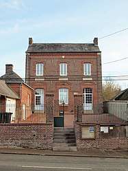 The town hall in Saint-Germain-sur-Bresle | |
 Saint-Germain-sur-Bresle Location within Hauts-de-France region  Saint-Germain-sur-Bresle | |
| Coordinates: 49°49′51″N 1°44′02″E / 49.8308°N 1.7339°ECoordinates: 49°49′51″N 1°44′02″E / 49.8308°N 1.7339°E | |
| Country | France |
| Region | Hauts-de-France |
| Department | Somme |
| Arrondissement | Amiens |
| Canton | Poix-de-Picardie |
| Intercommunality | CC Somme Sud-Ouest |
| Government | |
| • Mayor (2001–2008) | Michel Risville |
| Area1 | 8.69 km2 (3.36 sq mi) |
| Population (2006)2 | 189 |
| • Density | 22/km2 (56/sq mi) |
| Time zone | UTC+1 (CET) |
| • Summer (DST) | UTC+2 (CEST) |
| INSEE/Postal code | 80703 /80430 |
| Elevation |
83–208 m (272–682 ft) (avg. 121 m or 397 ft) |
|
1 French Land Register data, which excludes lakes, ponds, glaciers > 1 km2 (0.386 sq mi or 247 acres) and river estuaries. 2 Population without double counting: residents of multiple communes (e.g., students and military personnel) only counted once. | |
Saint-Germain-sur-Bresle is a commune in the Somme department in Hauts-de-France in northern France.
Geography
The commune is situated 16 miles (26 km) south of Abbeville, on the D316 road and by the banks of the river Bresle.
Population
| 1962 | 1968 | 1975 | 1982 | 1990 | 1999 | 2006 |
|---|---|---|---|---|---|---|
| 184 | 185 | 202 | 203 | 167 | 185 | 189 |
| Starting in 1962: Population without duplicates | ||||||
See also
References
| Wikimedia Commons has media related to Saint-Germain-sur-Bresle. |
This article is issued from
Wikipedia.
The text is licensed under Creative Commons - Attribution - Sharealike.
Additional terms may apply for the media files.