Rue, Somme
| Rue | ||
|---|---|---|
| Commune | ||
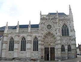 Chapelle du Saint-Esprit in Rue | ||
| ||
 Rue Location within Hauts-de-France region  Rue | ||
| Coordinates: 50°16′23″N 1°40′07″E / 50.2731°N 1.6686°ECoordinates: 50°16′23″N 1°40′07″E / 50.2731°N 1.6686°E | ||
| Country | France | |
| Region | Hauts-de-France | |
| Department | Somme | |
| Arrondissement | Abbeville | |
| Canton | Rue | |
| Intercommunality | CC Ponthieu-Marquenterre | |
| Government | ||
| • Mayor (2013–2014) | Philippe Mas | |
| Area1 | 29.06 km2 (11.22 sq mi) | |
| Population (2006)2 | 3,211 | |
| • Density | 110/km2 (290/sq mi) | |
| Time zone | UTC+1 (CET) | |
| • Summer (DST) | UTC+2 (CEST) | |
| INSEE/Postal code | 80688 /80120 | |
| Elevation |
2–12 m (6.6–39.4 ft) (avg. 9 m or 30 ft) | |
|
1 French Land Register data, which excludes lakes, ponds, glaciers > 1 km2 (0.386 sq mi or 247 acres) and river estuaries. 2 Population without double counting: residents of multiple communes (e.g., students and military personnel) only counted once. | ||

Rue is a commune in the Somme department in Hauts-de-France in northern France.
Geography
Rue is situated some 15 miles (24 km) north of Abbeville, on the junction of the D938, D4 and D85 roads.
Population
| 1962 | 1968 | 1975 | 1982 | 1990 | 1999 | 2006 |
|---|---|---|---|---|---|---|
| 2937 | 2952 | 3122 | 3170 | 2942 | 3075 | 3211 |
| Starting in 1962: Population without duplicates | ||||||
History
First known in the 9th century, when Vikings, from Rye, Denmark (pronounced "Ru"), first settled here. It would not have been much more than a group of huts in the marshes. Some local family names have Danish origins.
Places of interest
- The chapel of the Holy Spirit (1440–1514) is one of the finest examples of flamboyant gothic in Picardie.
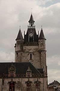
- The bell tower.
 Rue, Somme
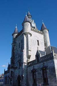 The Belfry at Rue
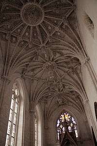 Interior of the chapel of the Holy Spirit
See also
References
External links
| Wikimedia Commons has media related to Rue (Somme). |
This article is issued from
Wikipedia.
The text is licensed under Creative Commons - Attribution - Sharealike.
Additional terms may apply for the media files.