Bougainville, Somme
| Bougainville | |
|---|---|
| Commune | |
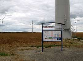 The Bougainville wind farm | |
 Bougainville Location within Hauts-de-France region  Bougainville | |
| Coordinates: 49°52′15″N 2°02′34″E / 49.8708°N 2.0428°ECoordinates: 49°52′15″N 2°02′34″E / 49.8708°N 2.0428°E | |
| Country | France |
| Region | Hauts-de-France |
| Department | Somme |
| Arrondissement | Amiens |
| Canton | Ailly-sur-Somme |
| Intercommunality | CC Somme Sud-Ouest |
| Government | |
| • Mayor (2001–2007) | Jean-Luc Consille |
| Area1 | 10.21 km2 (3.94 sq mi) |
| Population (2010)2 | 451 |
| • Density | 44/km2 (110/sq mi) |
| Time zone | UTC+1 (CET) |
| • Summer (DST) | UTC+2 (CEST) |
| INSEE/Postal code | 80119 /80540 |
| Elevation |
54–128 m (177–420 ft) (avg. 119 m or 390 ft) |
|
1 French Land Register data, which excludes lakes, ponds, glaciers > 1 km2 (0.386 sq mi or 247 acres) and river estuaries. 2 Population without double counting: residents of multiple communes (e.g., students and military personnel) only counted once. | |
Bougainville is a commune in the Somme department in Hauts-de-France in northern France.
Geography
Bougainville is situated on the D141 road, some 15 miles (24 km) west of Amiens.
Population
| Year | 1962 | 1968 | 1975 | 1982 | 1990 | 1999 | 2006 |
|---|---|---|---|---|---|---|---|
| Population | 353 | 358 | 374 | 406 | 413 | 409 | 485 |
| From the year 1962 on: No double counting—residents of multiple communes (e.g. students and military personnel) are counted only once. | |||||||
Places of interest
- Church of Saint-Arnould (18th century)
- Traces of a Gallo-Roman villa.
See also
References
External links
| Wikimedia Commons has media related to Bougainville (Somme). |
This article is issued from
Wikipedia.
The text is licensed under Creative Commons - Attribution - Sharealike.
Additional terms may apply for the media files.