Caix
| Caix | |
|---|---|
| Commune | |
 The church in Caix | |
 Caix Location within Hauts-de-France region  Caix | |
| Coordinates: 49°49′02″N 2°38′47″E / 49.8172°N 2.6464°ECoordinates: 49°49′02″N 2°38′47″E / 49.8172°N 2.6464°E | |
| Country | France |
| Region | Hauts-de-France |
| Department | Somme |
| Arrondissement | Péronne |
| Canton | Moreuil |
| Intercommunality | CC Terre de Picardie |
| Government | |
| • Mayor (2001–2008) | Daniel Mannens |
| Area1 | 11.95 km2 (4.61 sq mi) |
| Population (2010)2 | 732 |
| • Density | 61/km2 (160/sq mi) |
| Time zone | UTC+1 (CET) |
| • Summer (DST) | UTC+2 (CEST) |
| INSEE/Postal code | 80162 /80170 |
| Elevation |
53–97 m (174–318 ft) (avg. 90 m or 300 ft) |
|
1 French Land Register data, which excludes lakes, ponds, glaciers > 1 km2 (0.386 sq mi or 247 acres) and river estuaries. 2 Population without double counting: residents of multiple communes (e.g., students and military personnel) only counted once. | |
Caix is a commune in the Somme department in Hauts-de-France in northern France.
Geography
Caix is situated on the D28 road, some 20 miles (32 km) southeast of Amiens.
Population
| Year | 1962 | 1968 | 1975 | 1982 | 1990 | 1999 | 2006 |
|---|---|---|---|---|---|---|---|
| Population | 719 | 722 | 650 | 611 | 621 | 658 | 709 |
| From the year 1962 on: No double counting—residents of multiple communes (e.g. students and military personnel) are counted only once. | |||||||
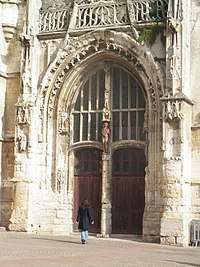
Church portal
See also
References
External links
| Wikimedia Commons has media related to Caix. |
- Caix on the Quid website (in French)
This article is issued from
Wikipedia.
The text is licensed under Creative Commons - Attribution - Sharealike.
Additional terms may apply for the media files.