Nurlu
| Nurlu | |
|---|---|
| Commune | |
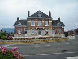 The town hall and school in Nurlu | |
 Nurlu Location within Hauts-de-France region  Nurlu | |
| Coordinates: 50°00′27″N 3°01′14″E / 50.0075°N 3.0206°ECoordinates: 50°00′27″N 3°01′14″E / 50.0075°N 3.0206°E | |
| Country | France |
| Region | Hauts-de-France |
| Department | Somme |
| Arrondissement | Péronne |
| Canton | Péronne |
| Intercommunality | Haute Somme |
| Government | |
| • Mayor (2001–2008) | Alain Baudelot |
| Area1 | 6.53 km2 (2.52 sq mi) |
| Population (2006)2 | 385 |
| • Density | 59/km2 (150/sq mi) |
| Time zone | UTC+1 (CET) |
| • Summer (DST) | UTC+2 (CEST) |
| INSEE/Postal code | 80601 /80240 |
| Elevation |
115–154 m (377–505 ft) (avg. 150 m or 490 ft) |
|
1 French Land Register data, which excludes lakes, ponds, glaciers > 1 km2 (0.386 sq mi or 247 acres) and river estuaries. 2 Population without double counting: residents of multiple communes (e.g., students and military personnel) only counted once. | |
Nurlu is a commune in the Somme department in Hauts-de-France in northern France.
Geography
Nurlu is situated on the D917 road, some 15 miles (24 km) northwest of Saint Quentin, in the far south-east of the département.
Population
| 1962 | 1968 | 1975 | 1982 | 1990 | 1999 | 2006 |
|---|---|---|---|---|---|---|
| 435 | 456 | 410 | 363 | 347 | 378 | 385 |
| Starting in 1962: Population without duplicates | ||||||
Places of interest
- The church, rebuilt by local architect Louis Faille.
- The Mairie and school, also rebuilt by Faille
- The house of Louis Faille
See also
References
External links
| Wikimedia Commons has media related to Nurlu. |
- Nurlu on the Quid website (in French)
This article is issued from
Wikipedia.
The text is licensed under Creative Commons - Attribution - Sharealike.
Additional terms may apply for the media files.