Selle
| The Selle | |
|---|---|
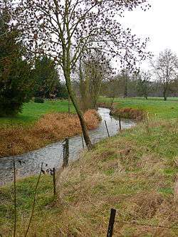 The Selle (or Celle) at Croissy-sur-Celle | |
| Country | France |
| Physical characteristics | |
| Main source | Catheux |
| River mouth |
Somme River 49°54′25″N 2°16′50″E / 49.90694°N 2.28056°ECoordinates: 49°54′25″N 2°16′50″E / 49.90694°N 2.28056°E |
| Length | 39 km (24 mi) |
| Discharge |
|
| Basin features | |
| Progression | Somme→ English Channel |
| Basin size | 610 km2 (240 sq mi) |
The Selle (also spelt Celle in the Oise) is a river of Picardy, France. Rising at Catheux, just north of Crèvecœur-le-Grand, Oise, it flows past Conty, Saleux, Salouël and Pont-de-Metz before joining the Somme River at Amiens.
In many places along its course, the river widens to form or fill lakes, much appreciated by anglers and gravel extractors. Several water-powered mills can still be seen including a paper-mill at Prouzel. Brown trout thrive in the clear waters of the river.
History
In 57 BC, the Selle was the site of the Battle of the Sabis between Julius Caesar and the Nervians, Atrebates and Viromandui.[1]
In World War I, during the Hundred Days Offensive of 1918, the German Army had taken up positions along the Selle near Le Cateau. General Rawlinson's Fourth Army spent two weeks preparing to assault these positions. The attack was launched on the night of 17 October when the river was crossed in foggy conditions and continued until the Germans were finally forced to retire on 20 October. The action is known as the Battle of the Selle.[2]
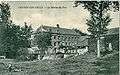 The watermill between Fontaine-Bonneleau and Croissy-sur-Celle
 The Mill at Croissy-sur-Celle
References
- ↑ Pierre Turquin ("La Bataille de la Selle (du Sabis) en l' An 57 avant J.-C." in Les Études Classiques 23/2 (1955), 113-156) has proved beyond reasonable doubt that the battle was fought near modern Saulzoir.
- ↑ The Western Front Association - Land War - The Battle of the Selle, October 1918
External links
| Wikimedia Commons has media related to Selle river. |
- Page about the Selle on the website of the Canton de Conty (in French)
- Banque Hydro - Station E6426010 - La Selle à Plachy-Buyon (option Synthèse) (in French)
- http://www.geoportail.fr
- The Selle at the Sandre database
Notes
- This article is based on the equivalent article from the French Wikipedia, consulted on February 20, 2008.