Rancourt, Somme
| Rancourt | |
|---|---|
| Commune | |
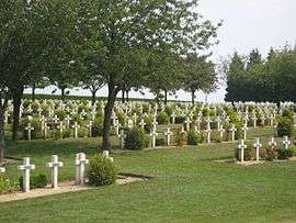 The war cemetery in Rancourt | |
 Rancourt Location within Hauts-de-France region  Rancourt | |
| Coordinates: 50°00′17″N 2°54′34″E / 50.0047°N 2.9094°E / 50.0047; 2.9094Coordinates: 50°00′17″N 2°54′34″E / 50.0047°N 2.9094°E / 50.0047; 2.9094 | |
| Country | France |
| Region | Hauts-de-France |
| Department | Somme |
| Arrondissement | Péronne |
| Canton | Péronne |
| Intercommunality | Haute Somme |
| Government | |
| • Mayor (2001–2008) | Dominique Bouchon |
| Area1 | 2.91 km2 (1.12 sq mi) |
| Population (2006)2 | 174 |
| • Density | 60/km2 (150/sq mi) |
| Time zone | UTC+1 (CET) |
| • Summer (DST) | UTC+2 (CEST) |
| INSEE/Postal code | 80664 /80360 |
| Elevation |
109–151 m (358–495 ft) (avg. 140 m or 460 ft) |
|
1 French Land Register data, which excludes lakes, ponds, glaciers > 1 km2 (0.386 sq mi or 247 acres) and river estuaries. 2 Population without double counting: residents of multiple communes (e.g., students and military personnel) only counted once. | |
Rancourt is a commune in the Somme department in Hauts-de-France in northern France.
Geography
Rancourt is situated 30 miles (48 km) northeast of Amiens, on the N17 road
Population
| 1962 | 1968 | 1975 | 1982 | 1990 | 1999 | 2006 |
|---|---|---|---|---|---|---|
| 90 | 108 | 113 | 128 | 143 | 144 | 174 |
| Starting in 1962: Population without duplicates | ||||||
See also
References
External links
| Wikimedia Commons has media related to Rancourt (Somme). |
- Rancourt on the Quid website (in French)
This article is issued from
Wikipedia.
The text is licensed under Creative Commons - Attribution - Sharealike.
Additional terms may apply for the media files.