Rainneville
| Rainneville | |
|---|---|
| Commune | |
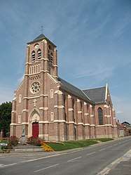 The church in Rainneville | |
 Rainneville Location within Hauts-de-France region  Rainneville | |
| Coordinates: 49°58′26″N 2°21′19″E / 49.9739°N 2.3553°ECoordinates: 49°58′26″N 2°21′19″E / 49.9739°N 2.3553°E | |
| Country | France |
| Region | Hauts-de-France |
| Department | Somme |
| Arrondissement | Amiens |
| Canton | Amiens-2 |
| Intercommunality | CC Territoire Nord Picardie |
| Government | |
| • Mayor (2001–2008) | Jacques Masset |
| Area1 | 7.11 km2 (2.75 sq mi) |
| Population (2006)2 | 772 |
| • Density | 110/km2 (280/sq mi) |
| Time zone | UTC+1 (CET) |
| • Summer (DST) | UTC+2 (CEST) |
| INSEE/Postal code | 80661 /80260 |
| Elevation |
79–131 m (259–430 ft) (avg. 150 m or 490 ft) |
|
1 French Land Register data, which excludes lakes, ponds, glaciers > 1 km2 (0.386 sq mi or 247 acres) and river estuaries. 2 Population without double counting: residents of multiple communes (e.g., students and military personnel) only counted once. | |
Rainneville is a commune in the Somme department of Hauts-de-France in northern France.
Geography
Rainneville is situated on the D11 road, some 7 miles (11 km) north of Amiens.
Population
| 1962 | 1968 | 1975 | 1982 | 1990 | 1999 | 2006 |
|---|---|---|---|---|---|---|
| 398 | 443 | 516 | 738 | 784 | 761 | 772 |
| Starting in 1962: Population without duplicates | ||||||
See also
References
External links
| Wikimedia Commons has media related to Rainneville. |
- Rainneville on the Quid website (in French)
| Authority control |
|---|
This article is issued from
Wikipedia.
The text is licensed under Creative Commons - Attribution - Sharealike.
Additional terms may apply for the media files.