Marcelcave
| Marcelcave | ||
|---|---|---|
| Commune | ||
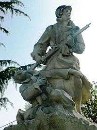 The war memorial in Marcelcave | ||
| ||
 Marcelcave Location within Hauts-de-France region  Marcelcave | ||
| Coordinates: 49°51′03″N 2°34′31″E / 49.8508°N 2.5753°ECoordinates: 49°51′03″N 2°34′31″E / 49.8508°N 2.5753°E | ||
| Country | France | |
| Region | Hauts-de-France | |
| Department | Somme | |
| Arrondissement | Amiens | |
| Canton | Corbie | |
| Intercommunality | Val de Somme | |
| Government | ||
| • Mayor (2001–2008) | Ghislain Fournet | |
| Area1 | 12.49 km2 (4.82 sq mi) | |
| Population (2006)2 | 1,031 | |
| • Density | 83/km2 (210/sq mi) | |
| Time zone | UTC+1 (CET) | |
| • Summer (DST) | UTC+2 (CEST) | |
| INSEE/Postal code | 80507 /80800 | |
| Elevation |
47–102 m (154–335 ft) (avg. 91 m or 299 ft) | |
|
1 French Land Register data, which excludes lakes, ponds, glaciers > 1 km2 (0.386 sq mi or 247 acres) and river estuaries. 2 Population without double counting: residents of multiple communes (e.g., students and military personnel) only counted once. | ||

Marcelcave is a commune in the Somme department in Hauts-de-France in northern France.
Geography
Marcelcave is situated on the D42 road, some 15 miles (24 km) east southeast of Amiens.
Population
| Year | 1962 | 1968 | 1975 | 1982 | 1990 | 1999 | 2006 |
|---|---|---|---|---|---|---|---|
| Population | 944 | 954 | 919 | 961 | 893 | 977 | 1031 |
| From the year 1962 on: No double counting—residents of multiple communes (e.g. students and military personnel) are counted only once. | |||||||
See also
References
External links
| Wikimedia Commons has media related to Marcelcave. |
- Marcelcave on the Quid website (in French)
This article is issued from
Wikipedia.
The text is licensed under Creative Commons - Attribution - Sharealike.
Additional terms may apply for the media files.