Tilloloy
- Not to be confused with Fresnes-Tilloloy
| Tilloloy | ||
|---|---|---|
| Commune | ||
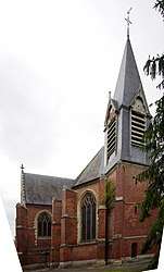 L'église Notre-Dame de Lorette | ||
| ||
 Tilloloy Location within Hauts-de-France region  Tilloloy | ||
| Coordinates: 49°38′38″N 2°44′55″E / 49.6439°N 2.7486°ECoordinates: 49°38′38″N 2°44′55″E / 49.6439°N 2.7486°E | ||
| Country | France | |
| Region | Hauts-de-France | |
| Department | Somme | |
| Arrondissement | Montdidier | |
| Canton | Roye | |
| Intercommunality | CC Grand Roye | |
| Government | ||
| • Mayor (2001–2008) | Gérard Comyn | |
| Area1 | 6.37 km2 (2.46 sq mi) | |
| Population (2006)2 | 396 | |
| • Density | 62/km2 (160/sq mi) | |
| Time zone | UTC+1 (CET) | |
| • Summer (DST) | UTC+2 (CEST) | |
| INSEE/Postal code | 80759 /80700 | |
| Elevation |
87–109 m (285–358 ft) (avg. 110 m or 360 ft) | |
|
1 French Land Register data, which excludes lakes, ponds, glaciers > 1 km2 (0.386 sq mi or 247 acres) and river estuaries. 2 Population without double counting: residents of multiple communes (e.g., students and military personnel) only counted once. | ||

Tilloloy is a commune in the Somme department in Hauts-de-France in northern France.
Geography
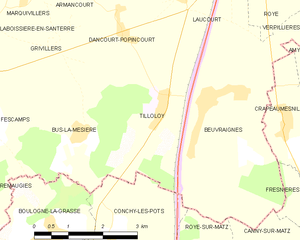
Tilloloy is situated in the east of the department 29 miles (47 km) southeast of Amiens, on the N17 road. The border with the Oise department is less than 1 mile (2 km) away.
Population
| 1962 | 1968 | 1975 | 1982 | 1990 | 1999 | 2006 |
|---|---|---|---|---|---|---|
| 340 | 386 | 414 | 378 | 372 | 388 | 396 |
| Starting in 1962: Population without duplicates | ||||||
Personalities
- Blaise Cendrars recounts in "La Main coupée" that the Foreign Legion squad he commanded in 1916 rested up in Tilloloy.
Places of interest
- The village church (shown in the lede image), which was subject of a painting by artist Maurice Denis.
- The seventeenth-century château of Tilloloy; extensively damaged in the First World War, subsequently restored.
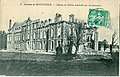 Château de Tilloloy with war-damage; front, photographic postcard circa 1915.
.jpg) A view from inside the ruined château in 1917, facing the rear "quadrangle"; painting on a war-charity art postcard.
A view from inside the ruined château in 1917, facing the rear "quadrangle"; painting on a war-charity art postcard.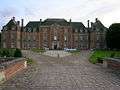 The rebuilt château, main facade; circa 2007.
See also
References
External links
| Wikimedia Commons has media related to Tilloloy. |
- Tilloloy on the Quid website (in French)
This article is issued from
Wikipedia.
The text is licensed under Creative Commons - Attribution - Sharealike.
Additional terms may apply for the media files.