Agenvillers
| Agenvillers | |
|---|---|
| Commune | |
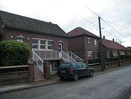 The town hall and school of Agenvillers | |
 Agenvillers Location within Hauts-de-France region  Agenvillers | |
| Coordinates: 50°10′45″N 1°55′13″E / 50.1792°N 1.9203°ECoordinates: 50°10′45″N 1°55′13″E / 50.1792°N 1.9203°E | |
| Country | France |
| Region | Hauts-de-France |
| Department | Somme |
| Arrondissement | Abbeville |
| Canton | Abbeville-1 |
| Intercommunality | CC Ponthieu-Marquenterre |
| Government | |
| • Mayor (2014-2020) | Ghyslain Hecquet |
| Area1 | 5.98 km2 (2.31 sq mi) |
| Population (2014)2 | 197 |
| • Density | 33/km2 (85/sq mi) |
| Time zone | UTC+1 (CET) |
| • Summer (DST) | UTC+2 (CEST) |
| INSEE/Postal code | 80006 /80150 |
| Elevation |
58–85 m (190–279 ft) (avg. 84 m or 276 ft) |
|
1 French Land Register data, which excludes lakes, ponds, glaciers > 1 km2 (0.386 sq mi or 247 acres) and river estuaries. 2 Population without double counting: residents of multiple communes (e.g., students and military personnel) only counted once. | |
Agenvillers is a commune in the Somme department in Hauts-de-France in northern France.
Geography
The communes is a small village about 13 km (8 mi) northeast of Abbeville, on the D82 departmental road.
Demography
| Year | 1962 | 1968 | 1975 | 1982 | 1990 | 1999 | 2006 |
|---|---|---|---|---|---|---|---|
| Population | 209 | 224 | 206 | 205 | 198 | 181 | 194 |
| From the year 1962 on: No double counting—residents of multiple communes (e.g. students and military personnel) are counted only once. | |||||||
See also
References
External links
| Wikimedia Commons has media related to Agenvillers. |
(All French language)
- Official website of the community
- Agenvillers on the website of Quid
- Position of Agenvillers on a map of France
This article is issued from
Wikipedia.
The text is licensed under Creative Commons - Attribution - Sharealike.
Additional terms may apply for the media files.