Proyart
| Proyart | |
|---|---|
| Commune | |
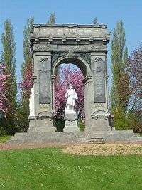 The war memorial in Proyart | |
 Proyart Location within Hauts-de-France region  Proyart | |
| Coordinates: 49°53′16″N 2°42′29″E / 49.8878°N 2.7081°E / 49.8878; 2.7081Coordinates: 49°53′16″N 2°42′29″E / 49.8878°N 2.7081°E / 49.8878; 2.7081 | |
| Country | France |
| Region | Hauts-de-France |
| Department | Somme |
| Arrondissement | Péronne |
| Canton | Ham |
| Intercommunality | CC Terre de Picardie |
| Government | |
| • Mayor (2001–2008) | Jacques Quillet |
| Area1 | 9.86 km2 (3.81 sq mi) |
| Population (2006)2 | 601 |
| • Density | 61/km2 (160/sq mi) |
| Time zone | UTC+1 (CET) |
| • Summer (DST) | UTC+2 (CEST) |
| INSEE/Postal code | 80644 /80340 |
| Elevation |
32–93 m (105–305 ft) (avg. 85 m or 279 ft) |
|
1 French Land Register data, which excludes lakes, ponds, glaciers > 1 km2 (0.386 sq mi or 247 acres) and river estuaries. 2 Population without double counting: residents of multiple communes (e.g., students and military personnel) only counted once. | |
Proyart is a commune in the Somme department in Hauts-de-France in northern France.
Geography
Proyart is situated on the D329 road, some 20 miles (32 km) east of Amiens.
Population
| 1962 | 1968 | 1975 | 1982 | 1990 | 1999 | 2006 |
|---|---|---|---|---|---|---|
| 501 | 527 | 513 | 509 | 514 | 522 | 601 |
| Starting in 1962: Population without duplicates | ||||||
Places of interest
- War memorial
- The château
See also
References
External links
| Wikimedia Commons has media related to Proyart. |
- Proyart on the Quid website (in French)
This article is issued from
Wikipedia.
The text is licensed under Creative Commons - Attribution - Sharealike.
Additional terms may apply for the media files.