Bussu, Somme
| Bussu | |
|---|---|
| Commune | |
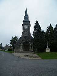 The church in Bussu | |
 Bussu Location within Hauts-de-France region  Bussu | |
| Coordinates: 49°56′47″N 2°58′39″E / 49.9464°N 2.9775°ECoordinates: 49°56′47″N 2°58′39″E / 49.9464°N 2.9775°E | |
| Country | France |
| Region | Hauts-de-France |
| Department | Somme |
| Arrondissement | Péronne |
| Canton | Péronne |
| Intercommunality | Haute Somme |
| Government | |
| • Mayor (2008–2014) | Géry Compere |
| Area1 | 6.79 km2 (2.62 sq mi) |
| Population (2006)2 | 223 |
| • Density | 33/km2 (85/sq mi) |
| Time zone | UTC+1 (CET) |
| • Summer (DST) | UTC+2 (CEST) |
| INSEE/Postal code | 80154 /80200 |
| Elevation |
52–129 m (171–423 ft) (avg. 70 m or 230 ft) |
|
1 French Land Register data, which excludes lakes, ponds, glaciers > 1 km2 (0.386 sq mi or 247 acres) and river estuaries. 2 Population without double counting: residents of multiple communes (e.g., students and military personnel) only counted once. | |
Bussu is a commune in the Somme département in Hauts-de-France in northern France.
Geography
Bussu is situated on the D181 road, some 20 miles (32 km) northwest of Saint-Quentin.
Population
| Year | 1962 | 1968 | 1975 | 1982 | 1990 | 1999 | 2006 |
|---|---|---|---|---|---|---|---|
| Population | 228 | 255 | 244 | 260 | 231 | 229 | 223 |
| From the year 1962 on: No double counting—residents of multiple communes (e.g. students and military personnel) are counted only once. | |||||||
See also
References
External links
| Wikimedia Commons has media related to Bussu. |
- Bussu on the Quid site (in French)
This article is issued from
Wikipedia.
The text is licensed under Creative Commons - Attribution - Sharealike.
Additional terms may apply for the media files.