Chase County, Kansas
| Chase County, Kansas | |
|---|---|
| County | |
Courthouse.JPG) | |
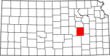 Location in the U.S. state of Kansas | |
 Kansas's location in the U.S. | |
| Coordinates: 38°18′N 96°35′W / 38.300°N 96.583°W | |
| Founded | February 11, 1859 |
| Named for | Salmon P. Chase |
| Seat | Cottonwood Falls |
| Largest city | Cottonwood Falls |
| Area | |
| • Total | 778 sq mi (2,015 km2) |
| • Land | 773 sq mi (2,002 km2) |
| • Water | 4.7 sq mi (12 km2), 0.6% |
| Population (est.) | |
| • (2016) | 2,669 |
| • Density | 3.6/sq mi (1.4/km2) |
| Area code(s) | 620 |
| Congressional district | 1st |
| Time zone | Central: UTC−6/−5 |
| Website | chasecountychamber.org |
Chase County (county code CS) is a county located in the U.S. state of Kansas. As of the 2010 census, the county population was 2,790.[1] Its county seat and most populous city is Cottonwood Falls.[2] The center of population of Kansas is located in Chase County, about four miles north of Strong City.
History
Early history
For many millennia, the Great Plains of North America was inhabited by nomadic Native Americans. From the 16th century to 18th century, the Kingdom of France claimed ownership of large parts of North America. In 1762, after the French and Indian War, France secretly ceded New France to Spain, per the Treaty of Fontainebleau. In 1802, Spain returned most of the land to France, but keeping title to about 7,500 square miles.
In 1803, most of the land for modern day Kansas was acquired by the United States from France as part of the 828,000 square mile Louisiana Purchase for 2.83 cents per acre. In 1848, after the Mexican–American War, the Treaty of Guadalupe Hidalgo with Spain brought into the United States all or part of land for ten future states, including southwest Kansas. In 1854, the Kansas Territory was organized, then in 1861 Kansas became the 34th U.S. state.
19th century
In 1806, Zebulon Pike led the Pike expedition westward from St Louis, Missouri, of which part of their journey followed the Cottonwood River through modern Chase County.[3]
In 1859, Chase County was established within the Kansas Territory.
In 1871, the Atchison, Topeka and Santa Fe Railway extended a main line from Emporia to Newton.[4] In 1887, Atchison, Topeka and Santa Fe Railway built a branch line from Neva (3 miles west of Strong City) to Superior, Nebraska. This branch line connected Strong City, Neva, Rockland, Diamond Springs, Burdick, Lost Springs, Jacobs, Hope, Navarre, Enterprise, Abilene, Talmage, Manchester, Longford, Oak Hill, Miltonvale, Aurora, Huscher, Concordia, Kackley, Courtland, Webber, Superior. At some point, the line from Neva to Lost Springs was pulled but the right of way has not been abandoned. This branch line was originally called "Strong City and Superior line" but later the name was shortened to the "Strong City line". In 1996, the Atchison, Topeka and Santa Fe Railway merged with Burlington Northern Railroad and renamed to the current BNSF Railway.
The south-western border one mile "notch" into Marion County was established under unusual circumstances. A murder had occurred and Marion County didn't want to have the trial, so a section one mile wide and eighteen miles long was ceded to Chase County to ensure the murder had occurred there.[5] The one mile strip of land remains in Chase County to this day.
20th century
In 1931, Notre Dame coach Knute Rockne died in a plane crash a few miles southwest of Bazaar, in Chase County, Kansas.
In 1996, the Tallgrass Prairie National Preserve was established in the county.
The county has been the subject of a book, PrairyErth (A Deep Map) by William Least Heat-Moon.
Historical markers
Historical maps
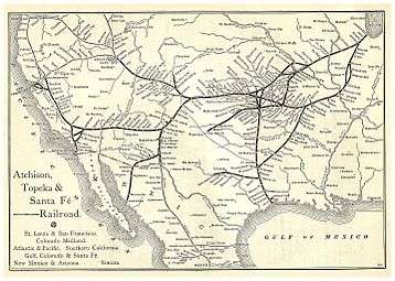 1891 Atchison, Topeka & Santa Fe Railway route map from Grain Dealers and Shippers Gazetteer.
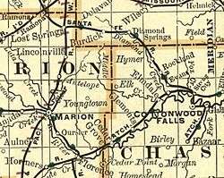 1893 Railroad Map.
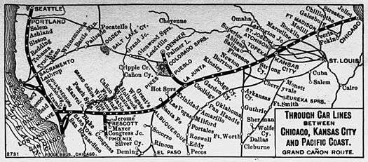 1900-1905 Atchison, Topeka & Santa Fe Railway route map of regular stops
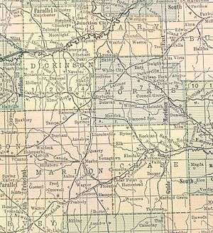 1914 railroad map.
 2000 Kansas population map.
Geography
According to the U.S. Census Bureau, the county has a total area of 778 square miles (2,020 km2), of which 773 square miles (2,000 km2) is land and 4.7 square miles (12 km2) (0.6%) is water.[10]
Chase County is centrally located in the eastern half of the state in the Flint Hills geologic region. It's located in the Neosho River drainage basin.[11]
Adjacent counties
- Morris County (north)
- Lyon County (east)
- Greenwood County (southeast)
- Butler County (southwest)
- Marion County (west)
National protected area
Major highways
Sources: National Atlas,[12] U.S. Census Bureau[13]
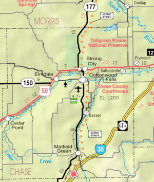
- Interstate 35 All of I-35 in Chase County is part of the Kansas Turnpike and inaccessible to the general public from within the county. The closest access points are via U.S. Route 50 in Emporia or Kansas Highway 177 in Cassoday. There is a private interchange located southeast of Bazaar for loading cattle. The overpass names the interchange the "Bazaar Cattle Crossing."[14]
- U.S. Route 50
- K-150
- K-177
Demographics
| Historical population | |||
|---|---|---|---|
| Census | Pop. | %± | |
| 1860 | 1,046 | — | |
| 1870 | 1,975 | 88.8% | |
| 1880 | 6,081 | 207.9% | |
| 1890 | 8,233 | 35.4% | |
| 1900 | 8,246 | 0.2% | |
| 1910 | 7,527 | −8.7% | |
| 1920 | 7,144 | −5.1% | |
| 1930 | 6,952 | −2.7% | |
| 1940 | 6,345 | −8.7% | |
| 1950 | 4,831 | −23.9% | |
| 1960 | 3,921 | −18.8% | |
| 1970 | 3,408 | −13.1% | |
| 1980 | 3,309 | −2.9% | |
| 1990 | 3,021 | −8.7% | |
| 2000 | 3,030 | 0.3% | |
| 2010 | 2,790 | −7.9% | |
| Est. 2016 | 2,669 | [15] | −4.3% |
| U.S. Decennial Census[16] 1790-1960[17] 1900-1990[18] 1990-2000[19] 2010-2016[1] | |||

As of the 2000 census,[20] there were 3,030 people, 1,246 households, and 817 families residing in the county. The population density was 4 people per square mile (2/km²). There were 1,529 housing units at an average density of 2 per square mile (1/km²). The racial makeup of the county was 96.90% White, 1.02% Black or African American, 0.56% Native American, 0.13% Asian, 0.56% from other races, and 0.83% from two or more races. Hispanic or Latino of any race were 1.75% of the population.
There were 1,246 households out of which 28.30% had children under the age of 18 living with them, 54.60% were married couples living together, 7.60% had a female householder with no husband present, and 34.40% were non-families. 31.10% of all households were made up of individuals and 14.90% had someone living alone who was 65 years of age or older. The average household size was 2.34 and the average family size was 2.92.
In the county, the population was spread out with 24.10% under the age of 18, 6.50% from 18 to 24, 26.60% from 25 to 44, 24.10% from 45 to 64, and 18.70% who were 65 years of age or older. The median age was 40 years. For every 100 females, there were 103.90 males. For every 100 females age 18 and over, there were 99.40 males.
The median income for a household in the county was $32,656, and the median income for a family was $39,848. Males had a median income of $27,402 versus $21,528 for females. The per capita income for the county was $17,422. About 4.10% of families and 8.60% of the population were below the poverty line, including 10.00% of those under age 18 and 6.30% of those age 65 or over.
Government
Presidential elections
| Year | Republican | Democratic | Third Parties |
|---|---|---|---|
| 2016 | 70.8% 969 | 23.1% 316 | 6.1% 84 |
| 2012 | 68.8% 875 | 28.2% 358 | 3.0% 38 |
| 2008 | 70.5% 976 | 27.7% 383 | 1.8% 25 |
| 2004 | 70.3% 1,055 | 27.9% 418 | 1.9% 28 |
| 2000 | 64.4% 848 | 29.7% 391 | 5.9% 78 |
| 1996 | 50.2% 778 | 32.0% 496 | 17.8% 276 |
| 1992 | 36.2% 610 | 27.9% 470 | 35.9% 605 |
| 1988 | 60.6% 884 | 36.9% 538 | 2.5% 36 |
| 1984 | 74.0% 1,162 | 25.0% 393 | 1.0% 15 |
| 1980 | 66.9% 1,073 | 25.8% 413 | 7.3% 117 |
| 1976 | 57.6% 922 | 40.2% 643 | 2.3% 36 |
| 1972 | 76.0% 1,184 | 20.2% 315 | 3.7% 58 |
| 1968 | 62.6% 1,038 | 27.9% 462 | 9.5% 158 |
| 1964 | 50.3% 902 | 49.4% 886 | 0.3% 5 |
| 1960 | 64.1% 1,276 | 35.5% 708 | 0.4% 8 |
| 1956 | 74.5% 1,553 | 25.4% 529 | 0.2% 4 |
| 1952 | 77.8% 1,815 | 22.0% 513 | 0.3% 6 |
| 1948 | 58.9% 1,432 | 39.6% 961 | 1.5% 37 |
| 1944 | 60.0% 1,510 | 39.7% 998 | 0.4% 9 |
| 1940 | 57.8% 1,871 | 41.5% 1,344 | 0.7% 23 |
| 1936 | 48.4% 1,610 | 51.3% 1,706 | 0.3% 9 |
| 1932 | 46.0% 1,485 | 52.7% 1,703 | 1.3% 43 |
| 1928 | 72.8% 2,079 | 25.9% 739 | 1.3% 38 |
| 1924 | 62.6% 1,822 | 26.1% 758 | 11.3% 330 |
| 1920 | 63.2% 1,659 | 34.4% 904 | 2.4% 64 |
| 1916 | 44.1% 1,356 | 51.6% 1,584 | 4.3% 132 |
| 1912 | 25.4% 476 | 43.4% 812 | 31.2% 585 |
| 1908 | 53.0% 1,021 | 43.3% 834 | 3.6% 70 |
| 1904 | 64.4% 1,217 | 29.7% 562 | 5.9% 111 |
| 1900 | 52.5% 1,084 | 46.3% 956 | 1.2% 25 |
| 1896 | 44.7% 812 | 54.1% 981 | 1.2% 22 |
| 1892 | 47.4% 891 | 52.7% 990 | |
| 1888 | 54.1% 1,126 | 28.5% 593 | 17.4% 362 |
Laws
Following amendment to the Kansas Constitution in 1986, the county remained a prohibition, or "dry", county until 1988, when voters approved the sale of alcoholic liquor by the individual drink with a 30% food sales requirement.[22]
Education
Unified school districts
- District Office In Neighboring County
Communities
Cities
Unincorporated places
- Bazaar
- Birley
- Clements
- Gladstone
- Homestead
- Hymer
- Rockland
- Rural
- Saffordville
- Toledo
- Wonsevu
Ghost towns
Townships
Chase County is divided into nine townships. None of the cities within the county are considered governmentally independent, and all figures for the townships include those of the cities. In the following table, the population center is the largest city (or cities) included in that township's population total, if it is of a significant size.
In popular culture
Made famous by William Least Heat-Moon's epic book PrairyErth: A Deep Map (1991).
NRHP sites
The following sites in Chase County are listed on the National Register of Historic Places:
|
|
See also
- National Register of Historic Places listings in Chase County, Kansas
- Cottonwood River and Great Flood of 1951
|
|
References
- 1 2 "State & County QuickFacts". United States Census Bureau. Retrieved July 22, 2014.
- ↑ "Find a County". National Association of Counties. Archived from the original on 2011-05-31. Retrieved 2011-06-07.
- ↑ 1806 Pike Expedition map through Marion County.
- ↑ Santa Fe Rail History
- ↑ Kansas State Historical Society - Marion County
- ↑ A Landmark of Distinction - The Chase County Courthouse; Historical Marker; Blue Skyways (archived).
- ↑ Chase County & The Bluestem Pasture Region of Kansas; Historical Marker; Blue Skyways (archived).
- ↑ The Bluestem Pasture Region of Kansas; Historical Marker; Blue Skyways (archived).
- ↑ W. B. Strong Memorial Railroad Park; Historical Marker; Blue Skyways (archived).
- ↑ "US Gazetteer files: 2010, 2000, and 1990". United States Census Bureau. 2011-02-12. Retrieved 2011-04-23.
- ↑

- ↑ National Atlas Archived December 5, 2008, at the Wayback Machine.
- ↑ U.S. Census Bureau TIGER shape files
- ↑ Google Maps Street View
- ↑ "Population and Housing Unit Estimates". Retrieved June 9, 2017.
- ↑ "U.S. Decennial Census". United States Census Bureau. Archived from the original on May 12, 2015. Retrieved July 22, 2014.
- ↑ "Historical Census Browser". University of Virginia Library. Retrieved July 22, 2014.
- ↑ "Population of Counties by Decennial Census: 1900 to 1990". United States Census Bureau. Retrieved July 22, 2014.
- ↑ "Census 2000 PHC-T-4. Ranking Tables for Counties: 1990 and 2000" (PDF). United States Census Bureau. Retrieved July 22, 2014.
- ↑ "American FactFinder". United States Census Bureau. Archived from the original on 2013-09-11. Retrieved 2008-01-31.
- ↑ http://uselectionatlas.org/RESULTS
- ↑ "Map of Wet and Dry Counties". Alcoholic Beverage Control, Kansas Department of Revenue. November 2006. Archived from the original on 2007-10-08. Retrieved 2007-12-26.
Further reading
- William Least Heat-Moon. PrairyErth (A Deep Map). Mariner Books; Reissue edition (February 15, 1999). ISBN 9780395925690.
- Chase County - Its Past, Present, and Future; Chase County Leader; May 28, 1914.
- Plat Book of Chase County, Kansas; North West Publishing Co; 39 pages; 1901.
External links
| Wikimedia Commons has media related to Chase County, Kansas. |
- Chase County - Official
- Chase County Maps: Current, Historic, KDOT
Places adjacent to Chase County, Kansas | ||||||||||
|---|---|---|---|---|---|---|---|---|---|---|
| ||||||||||
Municipalities and communities of Chase County, Kansas, United States | ||
|---|---|---|
| Cities | | |
| Unincorporated communities | ||
| Ghost towns | ||
| Townships | ||
| Footnotes | ‡This populated place also has portions in an adjacent county or counties | |
