Cedar Point, Kansas
| Cedar Point, Kansas | |
|---|---|
| City | |
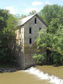 North side of 1875 Cedar Point Mill next to Cottonwood River (2012) | |
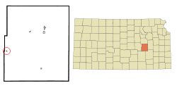 Location within Chase County and Kansas | |
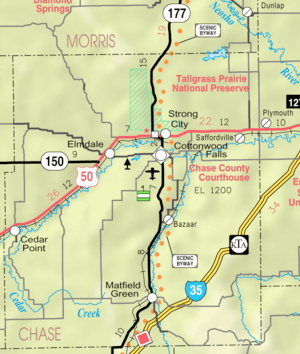 KDOT map of Chase County (legend) | |
| Coordinates: 38°15′36″N 96°49′11″W / 38.26000°N 96.81972°WCoordinates: 38°15′36″N 96°49′11″W / 38.26000°N 96.81972°W[1] | |
| Country | United States |
| State | Kansas |
| County | Chase |
| Township | Cottonwood |
| Government | |
| • Type | Mayor–Council |
| • Mayor | Christine Soyez[2] |
| • City Clerk | Sharon Dawson[2] |
| Area[3] | |
| • Total | 0.08 sq mi (0.21 km2) |
| • Land | 0.08 sq mi (0.21 km2) |
| • Water | 0 sq mi (0 km2) |
| Elevation[1] | 1,247 ft (380 m) |
| Population (2010)[4] | |
| • Total | 28 |
| • Estimate (2016)[5] | 27 |
| • Density | 350/sq mi (130/km2) |
| Time zone | UTC-6 (CST) |
| • Summer (DST) | UTC-5 (CDT) |
| ZIP code | 66843 |
| Area code | 620 |
| FIPS code | 20-11425 [1][6] |
| GNIS ID | 477384 [1][7] |
Cedar Point is a city in Chase County, Kansas, United States. As of the 2010 census, the city population was 28.[8]
History
Early history
For many millennia, the Great Plains of North America was inhabited by nomadic Native Americans. From the 16th century to 18th century, the Kingdom of France claimed ownership of large parts of North America. In 1762, after the French and Indian War, France secretly ceded New France to Spain, per the Treaty of Fontainebleau.
19th century
"Cedar Point" and "Cedar Grove"
In 1802, Spain returned most of the land to France. In 1803, most of the land for modern day Kansas was acquired by the United States from France as part of the 828,000 square mile Louisiana Purchase for 2.83 cents per acre.
In 1806, Zebulon Pike led the Pike expedition westward from St Louis, Missouri, of which part of their journey followed the Cottonwood River through Chase County near the current city of Cedar Point.[9]
In 1854, the Kansas Territory was organized, then in 1861 Kansas became the 34th U.S. state. In 1855, Marion County was established within the Kansas Territory, which included the land for modern day Cedar Point.
In 1862, Cedar Point was founded.[10] The first post office in Cedar Point was established in 1862.[11]
In 1867, a log dam was built across the Cottonwood River, and a wooden-frame mill was constructed for sawing lumber. The following year (1868) it was converted to grind flour and named Cedar Point Mill. In 1870, the name was changed to Drinkwater & Schriver Mill. In 1871, construction of the current stone structure was started, then completed in 1875. In 1884, the log dam was replaced by a stone dam.[12]
In 1871, the Atchison, Topeka and Santa Fe Railway built a main line east-west and built a nearby station named Cedar Grove in the valley north of Cedar Point.[13] In 1996, it merged with Burlington Northern Railroad and renamed to the current BNSF Railway. Most locals still refer to this railroad as the "Santa Fe".
Geography
Cedar Point is located at 38°15′39″N 96°49′18″W / 38.260888°N 96.821662°W (38.260888, -96.821662),[14] in the scenic Flint Hills of the Great Plains. According to the United States Census Bureau, the city has a total area of 0.08 square miles (0.21 km2), all of it land.[3]
Area attractions
Cedar Point has two listings on the National Register of Historic Places (NRHP).
Demographics
| Historical population | |||
|---|---|---|---|
| Census | Pop. | %± | |
| 1880 | 113 | — | |
| 1920 | 190 | — | |
| 1930 | 141 | −25.8% | |
| 1940 | 140 | −0.7% | |
| 1950 | 107 | −23.6% | |
| 1960 | 87 | −18.7% | |
| 1970 | 73 | −16.1% | |
| 1980 | 66 | −9.6% | |
| 1990 | 39 | −40.9% | |
| 2000 | 53 | 35.9% | |
| 2010 | 28 | −47.2% | |
| Est. 2016 | 27 | [5] | −3.6% |
| U.S. Decennial Census | |||
Cedar Point is part of the Emporia Micropolitan Statistical Area.
2010 census
As of the census[4] of 2010, there were 28 people, 13 households, and 5 families residing in the city. The population density was 350.0 inhabitants per square mile (135.1/km2). There were 25 housing units at an average density of 312.5 per square mile (120.7/km2). The racial makeup of the city was 96.4% White and 3.6% from two or more races.
There were 13 households of which 23.1% had children under the age of 18 living with them, 30.8% were married couples living together, 7.7% had a male householder with no wife present, and 61.5% were non-families. 46.2% of all households were made up of individuals and 38.5% had someone living alone who was 65 years of age or older. The average household size was 2.15 and the average family size was 3.60.
The median age in the city was 51.5 years. 28.6% of residents were under the age of 18; 0% were between the ages of 18 and 24; 10.7% were from 25 to 44; 32% were from 45 to 64; and 28.6% were 65 years of age or older. The gender makeup of the city was 53.6% male and 46.4% female.
2000 census
As of the census[6] of 2000, there were 53 people, 22 households, and 13 families residing in the city. The population density was 782.8 people per square mile (292.3/km2). There were 28 housing units at an average density of 413.5 per square mile (154.4/km2). The racial makeup of the city was 94.34% White, 1.89% Native American, and 3.77% from two or more races.
There were 22 households out of which 13.6% had children under the age of 18 living with them, 50.0% were married couples living together, 13.6% had a female householder with no husband present, and 36.4% were non-families. 31.8% of all households were made up of individuals and 13.6% had someone living alone who was 65 years of age or older. The average household size was 2.41 and the average family size was 3.00.
In the city, the population was spread out with 22.6% under the age of 18, 17.0% from 18 to 24, 18.9% from 25 to 44, 24.5% from 45 to 64, and 17.0% who were 65 years of age or older. The median age was 38 years. For every 100 females, there were 96.3 males. For every 100 females age 18 and over, there were 95.2 males.
As of 2000 the median income for a household in the city was $28,750, and the median income for a family was $36,250. Males had a median income of $40,000 versus $42,500 for females. The per capita income for the city was $16,102. There were no families and 3.6% of the population living below the poverty line, including no under eighteens and none of those over 64.
Government
The Cedar Point consists of a mayor and three council members. The council meets the 1st Tuesday of each month at 6:00 p.m.[2]
Education
Primary and Secondary Education
Cedar Point is part of Unified School District 284.[18][19] All students attend schools in Cottonwood Falls.
- Chase County Junior/Senior High School, 600 Main St in Cottonwood Falls.
- Chase County Elementary School, 401 Maple St in Cottonwood Falls.
Cedar Point schools were closed through school unification. The Cedar Point High School mascot was Cedar Point Bronchos.[20]
Media
Infrastructure
Transportation
U.S. Route 50 highway and BNSF Railway passes east-west near the city.
Utilities
- Internet
- TV
- Satellite is provided by DirecTV, Dish Network.
- Terrestrial is provided by regional digital TV stations.
- Electricity
- Rural is provided by Butler REC.
- Trash is provided by City of Florence.
See also
- Cedar Township, Chase County, Kansas
- Fort Drinkwater
- National Register of Historic Places listings in Chase County, Kansas
- 1875 Cedar Point Mill (Drinkwater & Schriver Mill)
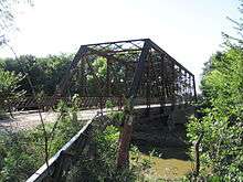
- 1916 Cottonwood River Pratt Truss Bridge
- Cottonwood River and Great Flood of 1951
- April 1956 tornado outbreak
Further reading
References
- 1 2 3 4 Geographic Names Information System (GNIS) details for Cedar Point, Kansas; United States Geological Survey (USGS); October 13, 1978.
- 1 2 3 Cedar Point - Directory of Public Officials
- 1 2 "US Gazetteer files 2010". United States Census Bureau. Archived from the original on 2012-01-24. Retrieved 2012-07-06.
- 1 2 "American FactFinder". United States Census Bureau. Retrieved 2012-07-06.
- 1 2 "Population and Housing Unit Estimates". Retrieved June 9, 2017.
- 1 2 "American FactFinder". United States Census Bureau. Archived from the original on 2013-09-11. Retrieved 2008-01-31.
- ↑ "US Board on Geographic Names". United States Geological Survey. 2007-10-25. Retrieved 2008-01-31.
- ↑ "2010 City Population and Housing Occupancy Status". U.S. Census Bureau. Archived from the original on July 21, 2011. Retrieved March 6, 2011.
- ↑ 1806 Pike Expedition map through Marion County.
- ↑ Kansas State Historical Society (1916). Biennial Report of the Board of Directors of the Kansas State Historical Society. Kansas State Printing Plant. p. 154.
- ↑ "Kansas Post Offices, 1828-1961 (archived)". Kansas Historical Society. Archived from the original on October 9, 2013. Retrieved 5 June 2014.
- ↑ Mill History; Drinkwater & Schriver Mill Inc.
- ↑ Santa Fe Rail History
- ↑ "US Gazetteer files: 2010, 2000, and 1990". United States Census Bureau. 2011-02-12. Retrieved 2011-04-23.
- ↑ National Register of Historic Places - Cedar Point Mill
- ↑ Drinkwater & Schriver Flour Mill - Kansas Travel
- ↑ National Register of Historic Places - Cottonwood River Pratt Truss Bridge
- ↑ USD 284
- ↑ Kansas School District Boundary Map Archived July 21, 2011, at the Wayback Machine.
- ↑ "Cedar Point Wins", The Emporia Gazette, 24 January 1946, p.12.
External links
| Wikimedia Commons has media related to Cedar Point, Kansas. |
- City
- Schools
- USD 284, school district for all of Chase County.
- Historical
- Cedar Point - A "Quiet" town of Chase County, Kansas, History and photographs.
- Cedar Point Mill and Dam between 1900 and 1920
- Maps
- Cedar Point City Map, KDOT
- Chase County Maps: Current, Historic, KDOT
Municipalities and communities of Chase County, Kansas, United States | ||
|---|---|---|
| Cities | 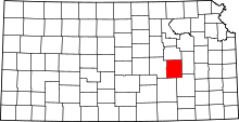 | |
| Unincorporated communities | ||
| Ghost towns | ||
| Townships | ||
| Footnotes | ‡This populated place also has portions in an adjacent county or counties | |