Cherokee County, Kansas
| Cherokee County, Kansas | |
|---|---|
| County | |
| Cherokee County | |
 | |
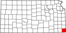 Location in the U.S. state of Kansas | |
 Kansas's location in the U.S. | |
| Coordinates: 37°10′N 94°51′W / 37.167°N 94.850°W | |
| Founded | February 18, 1860 |
| Named for | Cherokee Native Americans |
| Seat | Columbus |
| Largest city | Baxter Springs |
| Area | |
| • Total | 591 sq mi (1,531 km2) |
| • Land | 588 sq mi (1,523 km2) |
| • Water | 3.5 sq mi (9 km2), 0.6% |
| Population (est.) | |
| • (2016) | 20,246 |
| • Density | 37/sq mi (14/km2) |
| Area code(s) | 620 |
| Congressional district | 2nd |
| Time zone | Central: UTC−6/−5 |
| Website | cherokeecountyks.gov |
Cherokee County (county code CK) is a U.S. county located in Southeast Kansas. As of the 2010 census, the county population was 21,603.[1] Its county seat is Columbus,[2] and its most populous city is Baxter Springs. The latter became the first "cow town" in Kansas during the 1870s and the period of cattle drives.
History
19th century
In 1803, United States acquired from France the 828,000-square mile Louisiana Purchase, the former French lands west of the Mississippi River, for 2.83 cents per acre. This territory included most of the land for modern-day Kansas.
In the 1830s, the United States conducted Indian Removal of the Five Civilized Tribes from the Southeast region, to extinguish their land claims and allow European-American settlement in the area. They were given lands in what was called Indian Territory west of the Mississippi River, mostly in present-day Oklahoma. This part of Kansas was included at the time in the Cherokee Neutral Lands, and the county was named after this tribe.
In 1854, the US organized the Kansas Territory. Settlers began to move into the territory, with violence breaking out between supporters of slavery and those who wanted to abolish it. In 1861, Kansas was admitted as the 34th U.S. state; its constitution prohibited slavery. In 1860, Cherokee County was established.
Geography
According to the U.S. Census Bureau, the county has a total area of 591 square miles (1,530 km2), of which 588 square miles (1,520 km2) is land and 3.5 square miles (9.1 km2) (0.6%) is water.[3]
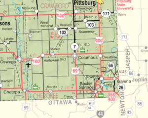
Adjacent counties
- Crawford County (north)
- Jasper County, Missouri (east)
- Newton County, Missouri (southeast)
- Ottawa County, Oklahoma (south)
- Craig County, Oklahoma (southwest)
- Labette County (west)
Major highways
Sources: National Atlas,[4] U.S. Census Bureau[5]
- U.S. Route 66 (decommissioned)
- U.S. Route 69
- U.S. Route 160
- U.S. Route 166
- Kansas Highway 7
- Kansas Highway 26
- Kansas Highway 57
- Kansas Highway 66 (successor to the decommissioned US 66)
- Kansas Highway 96
- Kansas Highway 102
Demographics
| Historical population | |||
|---|---|---|---|
| Census | Pop. | %± | |
| 1860 | 1,501 | — | |
| 1870 | 11,038 | 635.4% | |
| 1880 | 21,905 | 98.5% | |
| 1890 | 27,770 | 26.8% | |
| 1900 | 42,694 | 53.7% | |
| 1910 | 38,162 | −10.6% | |
| 1920 | 33,609 | −11.9% | |
| 1930 | 31,457 | −6.4% | |
| 1940 | 29,817 | −5.2% | |
| 1950 | 25,144 | −15.7% | |
| 1960 | 22,279 | −11.4% | |
| 1970 | 21,549 | −3.3% | |
| 1980 | 22,304 | 3.5% | |
| 1990 | 21,374 | −4.2% | |
| 2000 | 22,605 | 5.8% | |
| 2010 | 21,603 | −4.4% | |
| Est. 2016 | 20,246 | [6] | −6.3% |
| U.S. Decennial Census[7] 1790-1960[8] 1900-1990[9] 1990-2000[10] 2010-2016[1] | |||

As of the 2000 census,[11] there were 22,605 people, 8,875 households, and 6,239 families residing in the county. The population density was 38 people per square mile (15/km²). There were 10,031 housing units at an average density of 17 per square mile (7/km²). The racial makeup of the county was 92.27% White, 0.61% Black or African American, 3.45% Native American, 0.23% Asian, 0.04% Pacific Islander, 0.50% from other races, and 2.90% from two or more races. Hispanic or Latino of any race were 1.29% of the population.
There were 8,875 households out of which 32.40% had children under the age of 18 living with them, 56.60% were married couples living together, 9.70% had a female householder with no husband present, and 29.70% were non-families. 26.30% of all households were made up of individuals and 13.00% had someone living alone who was 65 years of age or older. The average household size was 2.51 and the average family size was 3.02.
In the county, the population was spread out with 26.50% under the age of 18, 8.40% from 18 to 24, 26.90% from 25 to 44, 23.10% from 45 to 64, and 15.20% who were 65 years of age or older. The median age was 37 years. For every 100 females there were 94.20 males. For every 100 females age 18 and over, there were 90.70 males.
The median income for a household in the county was $30,505, and the median income for a family was $37,284. Males had a median income of $29,045 versus $19,675 for females. The per capita income for the county was $14,710. About 11.40% of families and 14.30% of the population were below the poverty line, including 19.40% of those under age 18 and 10.60% of those age 65 or over.
Government
Presidential elections
| Year | Republican | Democratic | Third Parties |
|---|---|---|---|
| 2016 | 71.7% 6,182 | 23.3% 2,005 | 5.0% 433 |
| 2012 | 63.7% 5,456 | 34.2% 2,930 | 2.2% 185 |
| 2008 | 60.9% 5,886 | 37.2% 3,594 | 1.9% 185 |
| 2004 | 61.4% 6,083 | 37.6% 3,726 | 1.1% 104 |
| 2000 | 54.9% 5,014 | 41.4% 3,783 | 3.6% 333 |
| 1996 | 45.8% 4,138 | 41.7% 3,771 | 12.5% 1,134 |
| 1992 | 36.8% 3,589 | 41.9% 4,083 | 21.4% 2,085 |
| 1988 | 51.0% 4,281 | 48.4% 4,069 | 0.6% 52 |
| 1984 | 60.7% 5,801 | 38.3% 3,663 | 0.9% 89 |
| 1980 | 54.8% 5,296 | 41.1% 3,969 | 4.1% 397 |
| 1976 | 42.9% 3,957 | 55.9% 5,154 | 1.2% 107 |
| 1972 | 67.0% 6,019 | 31.3% 2,806 | 1.7% 155 |
| 1968 | 47.5% 4,211 | 40.5% 3,597 | 12.0% 1,064 |
| 1964 | 39.3% 3,730 | 60.2% 5,720 | 0.5% 47 |
| 1960 | 56.5% 5,753 | 42.8% 4,366 | 0.7% 73 |
| 1956 | 58.4% 5,824 | 41.2% 4,112 | 0.4% 39 |
| 1952 | 57.4% 6,261 | 42.1% 4,597 | 0.5% 56 |
| 1948 | 47.8% 4,616 | 50.2% 4,854 | 2.0% 193 |
| 1944 | 54.7% 5,458 | 44.7% 4,468 | 0.6% 62 |
| 1940 | 49.3% 6,600 | 49.8% 6,670 | 0.9% 126 |
| 1936 | 40.6% 5,445 | 58.9% 7,894 | 0.5% 69 |
| 1932 | 34.1% 4,045 | 62.6% 7,442 | 3.3% 393 |
| 1928 | 66.2% 7,478 | 30.5% 3,442 | 3.3% 376 |
| 1924 | 52.9% 5,437 | 29.9% 3,071 | 17.2% 1,770 |
| 1920 | 55.8% 5,466 | 39.1% 3,832 | 5.0% 492 |
| 1916 | 37.6% 4,350 | 53.4% 6,188 | 9.0% 1,047 |
| 1912 | 26.5% 1,994 | 35.2% 2,641 | 38.3% 2,878[lower-alpha 1] |
| 1908 | 44.3% 3,893 | 43.4% 3,819 | 12.3% 1,083 |
| 1904 | 55.8% 4,586 | 27.4% 2,253 | 16.8% 1,378 |
| 1900 | 45.2% 4,478 | 53.5% 5,302 | 1.3% 131 |
| 1896 | 40.2% 3,505 | 58.6% 5,108 | 1.2% 106 |
| 1892 | 41.4% 2,696 | 58.6% 3,812 | |
| 1888 | 45.6% 2,935 | 31.7% 2,038 | 22.7% 1,461 |
Laws
Although the Kansas Constitution was amended in 1986 to allow the sale of alcoholic liquor by the individual drink with the approval of voters, Cherokee County voters chose to remain a prohibition, or "dry", county until 2012.[13]
Education
Unified school districts
- Cherokee USD 247 (Web site) is a 300-square-mile (780 km2) school district primarily covering portions of Crawford and Cherokee counties, but also includes small portions of Labette and Neosho counties. It serves over 800 students in grades Pre-K through 12. Southeast High School (the "Lancers") is located just west of the city of Cherokee (where the district office is located). In Cherokee County the district serves the cities of Weir and West Mineral.[14]
- Riverton USD 404 (Web site)
- Columbus USD 493 (Web site)
- Galena USD 499 (Web site)
- Baxter Springs USD 508 (Web site)
Communities
Cities
- Baxter Springs
- Columbus
- Galena
- Oswego (mostly in Labette County)
- Roseland
- Scammon
- Weir
- West Mineral
Census-designated places
Other unincorporated communities
Ghost town
Townships
Cherokee County is divided into fourteen townships. The cities of Baxter Springs, Columbus, Galena, Scammon, and Weir are considered governmentally independent and are excluded from the census figures for the townships. In the following table, the population center is the largest city (or cities) included in that township's population total, if it is of a significant size.
| Township | FIPS | Population center |
Population | Population density /km² (/sq mi) |
Land area km² (sq mi) | Water area km² (sq mi) | Water % | Geographic coordinates |
|---|---|---|---|---|---|---|---|---|
| Cherokee | 12800 | 336 | 6 (15) | 57 (22) | 0 (0) | 0.08% | 37°18′33″N 94°45′36″W / 37.30917°N 94.76000°W | |
| Crawford | 16225 | 646 | 7 (18) | 94 (36) | 0 (0) | 0.24% | 37°9′21″N 94°47′11″W / 37.15583°N 94.78639°W | |
| Garden | 25250 | 3,039 | 41 (105) | 75 (29) | 2 (1) | 2.80% | 37°2′55″N 94°41′18″W / 37.04861°N 94.68833°W | |
| Lola | 42350 | 382 | 3 (9) | 115 (44) | 1 (0) | 0.50% | 37°10′25″N 95°0′15″W / 37.17361°N 95.00417°W | |
| Lowell | 43075 | 672 | 20 (52) | 33 (13) | 1 (0) | 3.04% | 37°6′11″N 94°40′23″W / 37.10306°N 94.67306°W | |
| Lyon | 43400 | 528 | 4 (11) | 130 (50) | 0 (0) | 0.08% | 37°2′19″N 94°52′37″W / 37.03861°N 94.87694°W | |
| Mineral | 47000 | 254 | 3 (8) | 79 (31) | 0 (0) | 0.15% | 37°15′32″N 94°47′29″W / 37.25889°N 94.79139°W | |
| Neosho | 49725 | 306 | 2 (5) | 157 (61) | 2 (1) | 1.08% | 37°3′15″N 95°1′37″W / 37.05417°N 95.02694°W | |
| Pleasant View | 56675 | 658 | 5 (13) | 136 (52) | 0 (0) | 0.14% | 37°17′4″N 94°40′1″W / 37.28444°N 94.66694°W | |
| Ross | 61350 | 893 | 6 (17) | 140 (54) | 1 (0) | 0.71% | 37°16′29″N 94°53′55″W / 37.27472°N 94.89861°W | |
| Salamanca | 62575 | 569 | 6 (17) | 89 (34) | 0 (0) | 0.07% | 37°10′3″N 94°52′37″W / 37.16750°N 94.87694°W | |
| Shawnee | 64475 | 505 | 6 (15) | 90 (35) | 1 (0) | 0.61% | 37°9′30″N 94°40′18″W / 37.15833°N 94.67167°W | |
| Sheridan | 64625 | 249 | 1 (4) | 172 (67) | 1 (1) | 0.79% | 37°15′41″N 95°0′15″W / 37.26139°N 95.00417°W | |
| Spring Valley | 67725 | 1,007 | 8 (21) | 122 (47) | 0 (0) | 0.36% | 37°3′11″N 94°46′5″W / 37.05306°N 94.76806°W | |
| Sources: "Census 2000 U.S. Gazetteer Files". U.S. Census Bureau, Geography Division. Archived from the original on 2002-08-02. | ||||||||
See also
|
|
References
- 1 2 "State & County QuickFacts". United States Census Bureau. Retrieved July 22, 2014.
- ↑ "Find a County". National Association of Counties. Archived from the original on 2015-05-10. Retrieved 2011-06-07.
- ↑ "US Gazetteer files: 2010, 2000, and 1990". United States Census Bureau. 2011-02-12. Retrieved 2011-04-23.
- ↑ National Atlas Archived December 5, 2008, at the Wayback Machine.
- ↑ U.S. Census Bureau TIGER shape files
- ↑ "Population and Housing Unit Estimates". Retrieved June 9, 2017.
- ↑ "U.S. Decennial Census". United States Census Bureau. Archived from the original on May 12, 2015. Retrieved July 22, 2014.
- ↑ "Historical Census Browser". University of Virginia Library. Retrieved July 22, 2014.
- ↑ "Population of Counties by Decennial Census: 1900 to 1990". United States Census Bureau. Retrieved July 22, 2014.
- ↑ "Census 2000 PHC-T-4. Ranking Tables for Counties: 1990 and 2000" (PDF). United States Census Bureau. Retrieved July 22, 2014.
- ↑ "American FactFinder". United States Census Bureau. Archived from the original on 2013-09-11. Retrieved 2008-01-31.
- ↑ http://uselectionatlas.org/RESULTS
- ↑ "Map of Wet and Dry Counties" (PDF). Alcoholic Beverage Control, Kansas Department of Revenue. December 2012. Retrieved 2013-12-26.
- ↑ Burns, Tim (September 19, 2005). "Welcome To USD #247". Cherokee, USD 247. Archived from the original on 2007-08-10. Retrieved 2007-01-23.
- 1 2 Rydjord, John (1972). Kansas Place-Names. University of Oklahoma Press, Norman, Oklahoma. p. 493. ISBN 0-8061-0994-7.
- ↑ Rydjord, John (1972). Kansas Place-Names. University of Oklahoma Press, Norman, Oklahoma. p. 491. ISBN 0-8061-0994-7.
- ↑ Rydjord, John (1972). Kansas Place-Names. University of Oklahoma Press, Norman, Oklahoma. p. 275. ISBN 0-8061-0994-7.
- ↑ Rydjord, John (1972). Kansas Place-Names. University of Oklahoma Press, Norman, Oklahoma. p. 245. ISBN 0-8061-0994-7.
- 1 2 3 Rydjord, John (1972). Kansas Place-Names. University of Oklahoma Press, Norman, Oklahoma. p. 494. ISBN 0-8061-0994-7.
- ↑ Former residents say goodbye to contaminated town of Treece; The Wichita Eagle; September 27, 2012. Archived September 30, 2012, at the Wayback Machine.
- Notes
- ↑ 2,006 votes for Socialist Eugene Debs and 872 for Progressive Theodore Roosevelt.
Further reading
- History of Cherokee County, Kansas; Biographical Publishing Co; 646 pages; 1904.
- Plat Book of Cherokee County, Kansas; Missouri Publishing Co; 35 pages; 1902.
External links
| Wikimedia Commons has media related to Cherokee County, Kansas. |
- County
- Historical
- Maps
- Cherokee County Maps: Current, Historic, KDOT
- Kansas Highway Maps: Current, Historic, KDOT
- Kansas Railroad Maps: Current, 1996, 1915, KDOT and Kansas Historical Society
Places adjacent to Cherokee County, Kansas | |
|---|---|
Municipalities and communities of Cherokee County, Kansas, United States | ||
|---|---|---|
| Cities | | |
| CDPs | ||
| Unincorporated communities | ||
| Ghost towns | ||
| Townships | ||
| Footnotes | ‡This populated place also has portions in an adjacent county or counties | |
