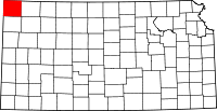
Cheyenne County, Kansas
| Cheyenne County, Kansas | |
|---|---|
| County | |
 | |
 Location in the U.S. state of Kansas | |
 Kansas's location in the U.S. | |
| Coordinates: 39°48′N 101°48′W / 39.800°N 101.800°W | |
| Founded | March 20, 1873 |
| Named for | Cheyenne Native Americans |
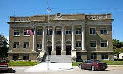
| Seat | St. Francis |
| Largest city | St. Francis |
| Area | |
| • Total | 1,021 sq mi (2,644 km2) |
| • Land | 1,020 sq mi (2,642 km2) |
| • Water | 1.1 sq mi (3 km2), 0.1% |
| Population (est.) | |
| • (2016) | 2,661 |
| • Density | 2.7/sq mi (1.0/km2) |
| Area code(s) | 785 |
| Congressional district | 1st |
| Time zone | Central: UTC−6/−5 |
| Website | cncoks.us |
Cheyenne County (county code CN) is a county located in the northwest corner of the U.S. state of Kansas. As of the 2010 census, the county population was 2,726.[1] Its county seat and most populous city is St. Francis.[2]
History
Early history
For many millennia, the Great Plains of North America was inhabited by nomadic Native Americans. From the 16th century to 18th century, the Kingdom of France claimed ownership of large parts of North America. In 1762, after the French and Indian War, France secretly ceded New France to Spain, per the Treaty of Fontainebleau.
19th century
In 1802, Spain returned most of the land to France, but keeping title to about 7,500 square miles. In 1803, most of the land for modern day Kansas was acquired by the United States from France as part of the 828,000 square mile Louisiana Purchase for 2.83 cents per acre.
In 1854, the Kansas Territory was organized, then in 1861 Kansas became the 34th U.S. state. In 1873, Cheyenne County was established.
Geography
According to the U.S. Census Bureau, the county has a total area of 1,021 square miles (2,640 km2), of which 1,020 square miles (2,600 km2) is land and 1.1 square miles (2.8 km2) (0.1%) is water.[3]
Adjacent counties
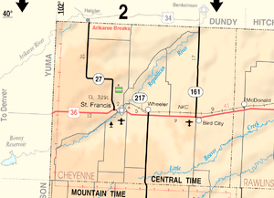
- Dundy County, Nebraska (north/Mountain Time border)
- Rawlins County (east)
- Sherman County (south/Mountain Time border)
- Kit Carson County, Colorado (southwest/Mountain Time border)
- Yuma County, Colorado (west/Mountain Time border)
Major highways
Time Zones
The county is bordered by the Mountain Time Zone in three directions, thus making it the only county in the United States to have this characteristic. Dundy County, Nebraska to the north, Yuma County, Colorado and Kit Carson County, Colorado to the west, and Sherman County to the south are all located in the Mountain Time Zone. As a result, Rawlins County is Cheyenne County's only neighbor to practice Central Time.
Demographics
| Historical population | |||
|---|---|---|---|
| Census | Pop. | %± | |
| 1880 | 37 | — | |
| 1890 | 4,401 | 11,794.6% | |
| 1900 | 2,640 | −40.0% | |
| 1910 | 4,248 | 60.9% | |
| 1920 | 5,587 | 31.5% | |
| 1930 | 6,948 | 24.4% | |
| 1940 | 6,221 | −10.5% | |
| 1950 | 5,668 | −8.9% | |
| 1960 | 4,708 | −16.9% | |
| 1970 | 4,256 | −9.6% | |
| 1980 | 3,678 | −13.6% | |
| 1990 | 3,243 | −11.8% | |
| 2000 | 3,165 | −2.4% | |
| 2010 | 2,726 | −13.9% | |
| Est. 2016 | 2,661 | [6] | −2.4% |
| U.S. Decennial Census[7] 1790-1960[8] 1900-1990[9] 1990-2000[10] 2010-2016[1] | |||

As of the 2000 census,[11] there were 3,165 people, 1,360 households, and 919 families residing in the county. The population density was 3 people per square mile (1/km²). There were 1,636 housing units at an average density of 2 per square mile (1/km²). The racial makeup of the county was 97.91% White, 0.13% Black or African American, 0.09% Native American, 0.32% Asian, 0.03% Pacific Islander, 0.98% from other races, and 0.54% from two or more races. Hispanic or Latino of any race were 2.59% of the population.
There were 1,360 households out of which 27.60% had children under the age of 18 living with them, 60.10% were married couples living together, 5.10% had a female householder with no husband present, and 32.40% were non-families. 30.80% of all households were made up of individuals and 17.30% had someone living alone who was 65 years of age or older. The average household size was 2.29 and the average family size was 2.85.
In the county, the population was spread out with 23.80% under the age of 18, 5.10% from 18 to 24, 22.70% from 25 to 44, 21.80% from 45 to 64, and 26.60% who were 65 years of age or older. The median age was 44 years. For every 100 females there were 97.30 males. For every 100 females age 18 and over, there were 92.40 males.
The median income for a household in the county was $30,599, and the median income for a family was $34,816. Males had a median income of $24,976 versus $19,569 for females. The per capita income for the county was $17,862. About 7.40% of families and 9.40% of the population were below the poverty line, including 11.80% of those under age 18 and 6.70% of those age 65 or over.
Government
Presidential elections
| Year | Republican | Democratic | Third Parties |
|---|---|---|---|
| 2016 | 83.4% 1,173 | 12.9% 181 | 3.8% 53 |
| 2012 | 81.3% 1,159 | 16.3% 233 | 2.4% 34 |
| 2008 | 76.6% 1,148 | 21.6% 323 | 1.8% 27 |
| 2004 | 80.0% 1,353 | 18.9% 320 | 1.1% 19 |
| 2000 | 76.0% 1,312 | 20.3% 350 | 3.8% 65 |
| 1996 | 66.8% 1,211 | 23.3% 422 | 9.9% 179 |
| 1992 | 49.2% 863 | 23.2% 407 | 27.6% 485 |
| 1988 | 63.4% 1,105 | 34.1% 594 | 2.5% 44 |
| 1984 | 79.1% 1,442 | 19.5% 356 | 1.4% 26 |
| 1980 | 73.9% 1,330 | 19.9% 358 | 6.2% 112 |
| 1976 | 55.8% 1,008 | 42.0% 758 | 2.2% 39 |
| 1972 | 75.5% 1,440 | 20.9% 399 | 3.6% 68 |
| 1968 | 70.7% 1,423 | 20.5% 412 | 8.9% 179 |
| 1964 | 56.2% 1,147 | 43.4% 886 | 0.3% 7 |
| 1960 | 71.4% 1,622 | 28.0% 636 | 0.6% 13 |
| 1956 | 68.8% 1,479 | 30.8% 663 | 0.4% 8 |
| 1952 | 75.6% 1,915 | 23.6% 597 | 0.8% 20 |
| 1948 | 53.5% 1,219 | 42.9% 978 | 3.6% 81 |
| 1944 | 68.0% 1,610 | 31.1% 736 | 0.9% 22 |
| 1940 | 64.1% 1,760 | 35.4% 971 | 0.5% 13 |
| 1936 | 42.4% 1,241 | 57.2% 1,673 | 0.4% 11 |
| 1932 | 34.6% 979 | 60.7% 1,716 | 4.7% 134 |
| 1928 | 69.6% 1,466 | 27.8% 586 | 2.6% 54 |
| 1924 | 50.4% 1,119 | 21.8% 485 | 27.8% 617 |
| 1920 | 62.4% 1,079 | 27.2% 471 | 10.4% 179 |
| 1916 | 31.8% 498 | 50.2% 787 | 18.0% 282 |
| 1912 | 15.9% 140 | 34.1% 301 | 50.0% 441 |
| 1908 | 54.3% 486 | 37.9% 339 | 7.8% 70 |
| 1904 | 72.9% 446 | 15.7% 96 | 11.4% 70 |
| 1900 | 54.1% 348 | 44.5% 286 | 1.4% 9 |
| 1896 | 49.6% 327 | 48.8% 322 | 1.7% 11 |
| 1892 | 50.5% 505 | 48.6% 486 | 1.0% 10 |
| 1888 | 63.1% 779 | 34.0% 420 | 2.9% 36 |
Laws
Following amendment to the Kansas Constitution in 1986, the county remained a prohibition, or "dry", county until 2000, when voters approved the sale of alcoholic liquor by the individual drink with a 30% food sales requirement.[13]
Education
Unified school districts
Communities
Cities
Unincorporated community
Ghost towns
- Clugh
- Gurney
- Hourglass
- Jaqua
- Lawnridge
- Orlando
Townships
Cheyenne County is divided into seven townships. None of the cities within the county are considered governmentally independent, and all figures for the township include those of the cities. In the following table, the population center is the largest city (or cities) included in that township's population total, if it is of a significant size.
| Township | FIPS | Population center |
Population | Population density /km² (/sq mi) |
Land area km² (sq mi) | Water area km² (sq mi) | Water % | Geographic coordinates |
|---|---|---|---|---|---|---|---|---|
| Benkelman | 06025 | 57 | 0 (1) | 186 (72) | 0 (0) | 0% | 39°37′8″N 101°54′35″W / 39.61889°N 101.90972°W | |
| Bird City | 06850 | Bird City | 771 | 1 (2) | 884 (341) | 0 (0) | 0.02% | 39°45′30″N 101°31′41″W / 39.75833°N 101.52806°W |
| Calhoun | 09950 | 57 | 0 (1) | 231 (89) | 2 (1) | 0.70% | 39°56′8″N 101°39′18″W / 39.93556°N 101.65500°W | |
| Cleveland Run | 14150 | 67 | 0 (1) | 186 (72) | 0 (0) | 0.08% | 39°52′35″N 101°48′20″W / 39.87639°N 101.80556°W | |
| Jaqua | 35025 | 46 | 0 (1) | 124 (48) | 0 (0) | 0.01% | 39°39′48″N 102°1′20″W / 39.66333°N 102.02222°W | |
| Orlando | 53050 | 63 | 1 (2) | 93 (36) | 0 (0) | 0% | 39°45′36″N 101°41′0″W / 39.76000°N 101.68333°W | |
| Wano | 75375 | St. Francis | 2,104 | 2 (6) | 937 (362) | 0 (0) | 0.05% | 39°45′27″N 101°50′4″W / 39.75750°N 101.83444°W |
| Sources: "Census 2000 U.S. Gazetteer Files". U.S. Census Bureau, Geography Division. Archived from the original on 2002-08-02. | ||||||||
See also
|
|
References
- 1 2 "State & County QuickFacts". United States Census Bureau. Retrieved July 22, 2014.
- ↑ "Find a County". National Association of Counties. Archived from the original on 2015-05-10. Retrieved 2011-06-07.
- ↑ "US Gazetteer files: 2010, 2000, and 1990". United States Census Bureau. 2011-02-12. Retrieved 2011-04-23.
- ↑ National Atlas Archived December 5, 2008, at the Wayback Machine.
- ↑ U.S. Census Bureau TIGER shape files
- ↑ "Population and Housing Unit Estimates". Retrieved June 9, 2017.
- ↑ "U.S. Decennial Census". United States Census Bureau. Archived from the original on May 12, 2015. Retrieved July 22, 2014.
- ↑ "Historical Census Browser". University of Virginia Library. Retrieved July 22, 2014.
- ↑ "Population of Counties by Decennial Census: 1900 to 1990". United States Census Bureau. Retrieved July 22, 2014.
- ↑ "Census 2000 PHC-T-4. Ranking Tables for Counties: 1990 and 2000" (PDF). United States Census Bureau. Retrieved July 22, 2014.
- ↑ "American FactFinder". United States Census Bureau. Archived from the original on 2013-09-11. Retrieved 2008-01-31.
- ↑ http://uselectionatlas.org/RESULTS
- ↑ "Map of Wet and Dry Counties". Alcoholic Beverage Control, Kansas Department of Revenue. November 2006. Archived from the original on 2007-10-08. Retrieved 2007-12-26.
Further reading
- Standard Atlas of Cheyenne County, Kansas; Geo. A. Ogle & Co; 48 pages; 1907.
External links
| Wikimedia Commons has media related to Cheyenne County, Kansas. |
- County
- Other
- Maps
- Cheyenne County Maps: Current, Historic, KDOT
- Kansas Highway Maps: Current, Historic, KDOT
- Kansas Railroad Maps: Current, 1996, 1915, KDOT and Kansas Historical Society
Places adjacent to Cheyenne County, Kansas | |
|---|---|
Municipalities and communities of Cheyenne County, Kansas, United States | ||
|---|---|---|
| Cities | | |
| Unincorporated communities | ||
| Ghost towns | ||
| Townships | ||
