Kingman County, Kansas
| Kingman County, Kansas | |
|---|---|
| County | |
 | |
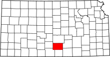 Location in the U.S. state of Kansas | |
 Kansas's location in the U.S. | |
| Founded | March 7, 1872 |
| Named for | Samuel A. Kingman |
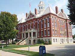
| Seat | Kingman |
| Largest city | Kingman |
| Area | |
| • Total | 867 sq mi (2,246 km2) |
| • Land | 863 sq mi (2,235 km2) |
| • Water | 3.3 sq mi (9 km2), 0.4% |
| Population (est.) | |
| • (2016) | 7,467 |
| • Density | 9.1/sq mi (3.5/km2) |
| Congressional district | 4th |
| Time zone | Central: UTC−6/−5 |
| Website | KingmanCoKS.com |
Kingman County (standard abbreviation: KM) is a county located in the U.S. state of Kansas. As of the 2010 census, the county population was 7,858.[1] The largest city and county seat is Kingman.
History
Early history
For many millennia, the Great Plains of North America was inhabited by nomadic Native Americans. From the 16th century to 18th century, the Kingdom of France claimed ownership of large parts of North America. In 1762, after the French and Indian War, France secretly ceded New France to Spain, per the Treaty of Fontainebleau.
19th century
In 1802, Spain returned most of the land to France, but keeping title to about 7,500 square miles. In 1803, most of the land for modern day Kansas was acquired by the United States from France as part of the 828,000 square mile Louisiana Purchase for 2.83 cents per acre.
In 1854, the Kansas Territory was organized, then in 1861 Kansas became the 34th U.S. state. In 1872, Kingman County was established and named for Samuel A. Kingman, chief justice of the Kansas Supreme Court.[2][3]
During the 1870s, Kingman County abounded with bison. The old-time cowboy author Frank H. Maynard reported going there on his first buffalo hunt.[4]
Geography
According to the U.S. Census Bureau, the county has a total area of 867 square miles (2,250 km2), of which 863 square miles (2,240 km2) is land and 3.3 square miles (8.5 km2) (0.4%) is water.[5]
Adjacent counties
- Reno County (north)
- Sedgwick County (east)
- Sumner County (southeast)
- Harper County (south)
- Barber County (southwest)
- Pratt County (west)
Demographics
| Historical population | |||
|---|---|---|---|
| Census | Pop. | %± | |
| 1880 | 3,713 | — | |
| 1890 | 11,823 | 218.4% | |
| 1900 | 10,663 | −9.8% | |
| 1910 | 13,386 | 25.5% | |
| 1920 | 12,119 | −9.5% | |
| 1930 | 11,674 | −3.7% | |
| 1940 | 12,001 | 2.8% | |
| 1950 | 10,324 | −14.0% | |
| 1960 | 9,958 | −3.5% | |
| 1970 | 8,886 | −10.8% | |
| 1980 | 8,960 | 0.8% | |
| 1990 | 8,292 | −7.5% | |
| 2000 | 8,673 | 4.6% | |
| 2010 | 7,858 | −9.4% | |
| Est. 2016 | 7,467 | [6] | −5.0% |
| U.S. Decennial Census[7] 1790-1960[8] 1900-1990[9] 1990-2000[10] 2010-2016[1] | |||
Kingman County is included in the Wichita, KS Metropolitan Statistical Area.
As of the census[11] of 2000, there were 8,673 people, 3,371 households, and 2,420 families residing in the county. The population density was 10 inhabitants per square mile (3.9/km2). There were 3,852 housing units at an average density of 4 per square mile (1.5/km2). The racial makeup of the county was 97.45% White, 0.21% Black or African American, 0.58% Native American, 0.24% Asian, 0.02% Pacific Islander, 0.35% from other races, and 1.15% from two or more races. 1.44% of the population were Hispanic or Latino of any race.
There were 3,371 households out of which 32.40% had children under the age of 18 living with them, 61.90% were married couples living together, 7.10% had a female householder with no husband present, and 28.20% were non-families. 26.00% of all households were made up of individuals and 13.80% had someone living alone who was 65 years of age or older. The average household size was 2.51 and the average family size was 3.03.
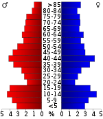
In the county, the population was spread out with 27.40% under the age of 18, 5.80% from 18 to 24, 24.70% from 25 to 44, 22.50% from 45 to 64, and 19.60% who were 65 years of age or older. The median age was 40 years. For every 100 females there were 96.30 males. For every 100 females age 18 and over, there were 93.50 males.
The median income for a household in the county was $37,790, and the median income for a family was $44,547. Males had a median income of $31,771 versus $25,298 for females. The per capita income for the county was $18,533. About 8.40% of families and 10.60% of the population were below the poverty line, including 16.90% of those under age 18 and 7.40% of those age 65 or over.
Government
Presidential elections
| Year | Republican | Democratic | Third Parties |
|---|---|---|---|
| 2016 | 75.9% 2,530 | 18.0% 599 | 6.2% 205 |
| 2012 | 74.2% 2,397 | 22.7% 733 | 3.1% 101 |
| 2008 | 71.0% 2,603 | 26.3% 963 | 2.7% 98 |
| 2004 | 74.4% 2,801 | 24.0% 904 | 1.6% 59 |
| 2000 | 70.2% 2,672 | 26.0% 991 | 3.8% 145 |
| 1996 | 64.7% 2,659 | 24.5% 1,006 | 10.9% 448 |
| 1992 | 40.4% 1,680 | 26.4% 1,100 | 33.2% 1,383 |
| 1988 | 58.7% 2,205 | 37.8% 1,420 | 3.4% 129 |
| 1984 | 72.0% 2,826 | 26.7% 1,047 | 1.3% 50 |
| 1980 | 63.6% 2,610 | 27.6% 1,133 | 8.8% 359 |
| 1976 | 44.9% 1,839 | 52.3% 2,142 | 2.7% 112 |
| 1972 | 68.9% 2,756 | 27.7% 1,107 | 3.4% 137 |
| 1968 | 60.3% 2,318 | 31.2% 1,201 | 8.5% 326 |
| 1964 | 45.9% 1,917 | 53.3% 2,226 | 0.8% 32 |
| 1960 | 62.3% 2,904 | 37.2% 1,735 | 0.5% 23 |
| 1956 | 69.1% 3,226 | 30.6% 1,428 | 0.3% 16 |
| 1952 | 76.5% 3,820 | 22.0% 1,096 | 1.5% 76 |
| 1948 | 55.9% 2,640 | 42.5% 2,008 | 1.6% 76 |
| 1944 | 63.7% 2,827 | 35.6% 1,579 | 0.7% 29 |
| 1940 | 54.4% 3,068 | 44.8% 2,528 | 0.9% 49 |
| 1936 | 35.1% 2,014 | 64.6% 3,705 | 0.2% 13 |
| 1932 | 38.0% 1,923 | 60.2% 3,050 | 1.8% 92 |
| 1928 | 69.6% 3,287 | 29.8% 1,408 | 0.6% 26 |
| 1924 | 54.3% 2,416 | 24.2% 1,077 | 21.5% 954 |
| 1920 | 63.2% 2,818 | 34.9% 1,557 | 1.9% 85 |
| 1916 | 38.3% 1,891 | 53.1% 2,626 | 8.6% 426 |
| 1912 | 11.0% 336 | 46.4% 1,421 | 42.7% 1,309 |
| 1908 | 47.3% 1,442 | 48.5% 1,479 | 4.3% 130 |
| 1904 | 63.2% 1,600 | 26.1% 661 | 10.7% 271 |
| 1900 | 50.8% 1,286 | 46.7% 1,183 | 2.5% 63 |
| 1896 | 40.9% 988 | 57.7% 1,393 | 1.5% 35 |
| 1892 | 43.1% 1,225 | 56.9% 1,616 | |
| 1888 | 50.2% 1,413 | 22.1% 622 | 27.7% 780 |
Laws
Following amendment to the Kansas Constitution in 1986, the county remained a prohibition, or "dry", county until 2004, when voters approved the sale of alcoholic liquor by the individual drink with a 30 percent food sales requirement.[13]
Education
Unified school districts
Communities

Cities
Unincorporated communities
- Adams
- Belmont
- Calista
- Cleveland
- Midway
- Mount Vernon
- Murdock
- Rago
- Skellyville
- St. Leo
- Varner
- Waterloo
- Willowdale
Townships
Kingman County is divided into twenty-three townships. The city of Kingman is considered governmentally independent and is excluded from the census figures for the townships. In the following table, the population center is the largest city (or cities) included in that township's population total, if it is of a significant size.
See also
|
|
References
- 1 2 "State & County QuickFacts". United States Census Bureau. Archived from the original on July 13, 2011. Retrieved July 26, 2014.
- ↑ Kansas State Historical Society (1916). Biennial Report of the Board of Directors of the Kansas State Historical Society. Kansas State Printing Plant. p. 215.
- ↑ "Samuel Austin Kingman". Kansas Historical Society. Retrieved April 21, 2016.
- ↑ Maynard, Frank H. Cowboy's Lament: A Life on the Open Range. Lubbock, Texas: Texas Tech University Press, 2010, 3. ISBN 978-0-89672-705-2.
- ↑ "US Gazetteer files: 2010, 2000, and 1990". United States Census Bureau. 2011-02-12. Retrieved 2011-04-23.
- ↑ "Population and Housing Unit Estimates". Retrieved June 9, 2017.
- ↑ "U.S. Decennial Census". United States Census Bureau. Archived from the original on May 12, 2015. Retrieved July 26, 2014.
- ↑ "Historical Census Browser". University of Virginia Library. Retrieved July 26, 2014.
- ↑ "Population of Counties by Decennial Census: 1900 to 1990". United States Census Bureau. Retrieved July 26, 2014.
- ↑ "Census 2000 PHC-T-4. Ranking Tables for Counties: 1990 and 2000" (PDF). United States Census Bureau. Retrieved July 26, 2014.
- ↑ "American FactFinder". United States Census Bureau. Retrieved 2008-01-31.
- ↑ http://uselectionatlas.org/RESULTS
- ↑ "Map of Wet and Dry Counties". Alcoholic Beverage Control, Kansas Department of Revenue. November 2006. Archived from the original on 2007-10-08. Retrieved 2007-12-26.
Further reading
- Standard Atlas of Kingman County, Kansas; Geo. A. Ogle & Co; 74 pages; 1921.
- Plat Book of Kingman County, Kansas; Northwest Publishing Co; 45 pages; 1903.
External links
| Wikimedia Commons has media related to Kingman County, Kansas. |
- County
- Kingman County - Official
- Kingman County - Directory of Public Officials
- Kingman County - Economic Development Council
- Maps
- Kingman County Maps: Current, Historic, KDOT
- Kansas Highway Maps: Current, Historic, KDOT
- Kansas Railroad Maps: Current, 1996, 1915, KDOT and Kansas Historical Society
Places adjacent to Kingman County, Kansas | ||||||||||
|---|---|---|---|---|---|---|---|---|---|---|
| ||||||||||
Municipalities and communities of Kingman County, Kansas, United States | ||
|---|---|---|
| Cities | | |
| Unincorporated communities |
| |
| Townships | ||
