Wyandotte County, Kansas
| Wyandotte County, Kansas | |
|---|---|
| County | |
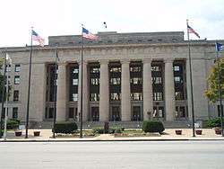 Wyandotte County Courthouse in Kansas City | |
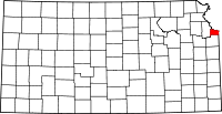 Location in the U.S. state of Kansas | |
 Kansas's location in the U.S. | |
| Founded | January 29, 1859 |
| Named for | Wyandot people |
| Seat | Kansas City |
| Largest city | Kansas City |
| Area | |
| • Total | 156 sq mi (404 km2) |
| • Land | 152 sq mi (394 km2) |
| • Water | 4.6 sq mi (12 km2), 2.9% |
| Population (est.) | |
| • (2016) | 163,831 |
| • Density | 1,039/sq mi (401/km2) |
| Congressional district | 3rd |
| Time zone | Central: UTC−6/−5 |
| Website | wycokck.org |
Wyandotte County (/ˈwaɪ.əndɒt/; county code WY) is a county located in the U.S. state of Kansas. As of the 2010 census, the population was 157,505,[1] making it the fourth-most populous county in Kansas. Its county seat and most populous city is Kansas City,[2] with which it shares a unified government. Wyandotte County lies immediately west of Kansas City, Missouri.
History

The Wyandot
The county is named after the Wyandot (also known as Wyandott or Wyandotte) Indians. They were called the Huron by the French in Canada, but they called themselves Wendat. They were distantly related to the Iroquois, with whom they sometimes fought. They had hoped to hold off movement by white Americans into their territory and had hoped to make the Ohio River the border between the United States and Canada.[3]
One branch of the Wyandot moved to the area that is now the state of Ohio. They generally took the course of assimilation into Anglo-American society. Many of them embraced Christianity under the influence of missionaries. They were transported to the current area of Wyandotte County in 1843, where they set up a community and worked in cooperation with Anglo settlers. The Christian Munsee also influenced early settlement of this area.[4]
The Wyandot in Kansas set up a constitutional form of government that they had devised in Ohio. They set up the territorial government for Kansas and Nebraska. It was one of their own who was elected as territorial governor.
Other historical facts
The county was organized in 1859.[5] Tenskwatawa (Tecumseh's brother), "the Prophet", fought at the Battle of Tippecanoe in 1811. He was buried at Shawnee Native American historical site Whitefeather Spring (located at 3818 Ruby Ave., Kansas City, which was added in 1975 to the National Register of Historic Places). The Kansas City Smelting and Refining Company employed over 250 men during the 1880s. The ore and base bullion is received from the mining districts of the mountains and is here crushed, separated and refined.
The Delaware Crossing (or "Military Crossing"; sometimes "the Secondine") was where the old Indian trail met the waters of the Kaw River. Circa 1831, Moses Grinter (one of the earliest permanent white settlers in the area) set up the Grinter Ferry on the Kansas River here. His house was known was the Grinter Place. The ferry was used by individuals (such as traders, freighters, and soldiers) traveling between Fort Leavenworth and Fort Scott on the military road. Others would cross this area on their way to Santa Fe.
The Diocese of Leavenworth moved its see from Leavenworth, Kansas to Kansas City, Kansas on 10 May 1947. It became an Archdiocese on 9 August 1952.
Geography
According to the U.S. Census Bureau, the county has a total area of 156 square miles (400 km2), of which 152 square miles (390 km2) is land and 4.6 square miles (12 km2) (2.9%) is water.[6] It is the smallest county by area in Kansas.[7]
Topography
The natural topography of the county consists of gently rolling terrain. The Kansas River forms a portion of the southern boundary of the county. The elevation generally increases from south to north as the distance from the Kansas River and Missouri River increases.
Watersheds & Streams
The county is drained by the watersheds of the Kansas River which is part of the Missouri River watershed. Being located in northeastern Kansas, the county receives plentiful rainfall.
Adjacent counties
- Platte County, Missouri (north)
- Clay County, Missouri (northeast)
- Jackson County, Missouri (east)
- Johnson County (south)
- Leavenworth County (west)
Demographics
| Historical population | |||
|---|---|---|---|
| Census | Pop. | %± | |
| 1860 | 2,609 | — | |
| 1870 | 10,015 | 283.9% | |
| 1880 | 19,143 | 91.1% | |
| 1890 | 54,407 | 184.2% | |
| 1900 | 73,227 | 34.6% | |
| 1910 | 100,068 | 36.7% | |
| 1920 | 122,218 | 22.1% | |
| 1930 | 141,211 | 15.5% | |
| 1940 | 145,071 | 2.7% | |
| 1950 | 165,318 | 14.0% | |
| 1960 | 185,495 | 12.2% | |
| 1970 | 186,845 | 0.7% | |
| 1980 | 172,335 | −7.8% | |
| 1990 | 161,993 | −6.0% | |
| 2000 | 157,882 | −2.5% | |
| 2010 | 157,505 | −0.2% | |
| Est. 2016 | 163,831 | [8] | 4.0% |
| U.S. Decennial Census[9] 1790-1960[10] 1900-1990[11] 1990-2000[12] 2010-2016[1] | |||
Wyandotte County is included in the Kansas City, MO-KS Metropolitan Statistical Area.
Wyandotte County's population was estimated to be 163,369 in the year 2015, a increase of 5,864, or +3.0%, over the previous five years; it is the fourth largest county (in population) in the state of Kansas.
As of the 2000 census, there were 157,882 people, 59,700 households, and 39,163 families residing in the county. The population density was 1,043 people per square mile (403/km²). There were 65,892 housing units at an average density of 435 per square mile (168/km²). The racial makeup of the county was 58.18% White, 28.33% Black or African American, 1.63% Asian, 0.74% Native American, 0.04% Pacific Islander, 8.17% from other races, and 2.91% from two or more races. Hispanic or Latino of any race were 16.00% of the population.
By 2007, 48.1% of Wyandotte County's population was non-Hispanic whites. 26.3% of the population was African-American. Native Americans made up 0.6% of the population. Asians were 1.8% of the population. Latinos made up 21.7% of the county's population.
There were 59,700 households out of which 32.60% had children under the age of 18 living with them, 42.10% were married couples living together, 17.80% had a female householder with no husband present, and 34.40% were non-families. 28.90% of all households were made up of individuals and 10.00% had someone living alone who was 65 years of age or older. The average household size was 2.62 and the average family size was 3.24.
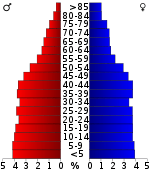
In the county, the population was spread out with 28.50% under the age of 18, 10.40% from 18 to 24, 29.50% from 25 to 44, 19.90% from 45 to 64, and 11.70% who were 65 years of age or older. The median age was 32 years. For every 100 females there were 95.40 males. For every 100 females age 18 and over, there were 91.30 males.
The median income for a household in the county was $33,784, and the median income for a family was $40,333. Males had a median income of $31,335 versus $24,640 for females. The per capita income for the county was $16,005. About 12.50% of families and 16.50% of the population were below the poverty line, including 23.00% of those under age 18 and 11.10% of those age 65 or over.
Approximately 1.4 percent of the county’s residents use public transportation to get to work. This is the highest percentage in the state.[13]
Government
Presidential elections
| Year | Republican | Democratic | Third Parties |
|---|---|---|---|
| 2016 | 32.1% 15,806 | 61.2% 30,146 | 6.7% 3,291 |
| 2012 | 30.5% 15,496 | 67.4% 34,302 | 2.2% 1,095 |
| 2008 | 28.8% 16,506 | 69.4% 39,865 | 1.8% 1,038 |
| 2004 | 33.6% 17,919 | 65.4% 34,923 | 1.1% 559 |
| 2000 | 29.1% 14,024 | 67.1% 32,411 | 3.8% 1,837 |
| 1996 | 28.2% 14,011 | 62.9% 31,252 | 8.9% 4,391 |
| 1992 | 21.1% 12,872 | 56.3% 34,397 | 22.7% 13,855 |
| 1988 | 32.7% 19,097 | 66.2% 38,678 | 1.1% 624 |
| 1984 | 42.8% 27,459 | 56.2% 36,042 | 1.0% 635 |
| 1980 | 38.2% 23,012 | 54.4% 32,763 | 7.4% 4,448 |
| 1976 | 37.0% 23,141 | 59.9% 37,478 | 3.1% 1,936 |
| 1972 | 52.7% 34,157 | 43.5% 28,206 | 3.8% 2,453 |
| 1968 | 33.4% 23,091 | 49.4% 34,189 | 17.2% 11,891 |
| 1964 | 31.5% 20,553 | 66.5% 43,442 | 2.1% 1,356 |
| 1960 | 45.3% 34,764 | 54.0% 41,433 | 0.8% 604 |
| 1956 | 47.6% 34,604 | 52.1% 37,842 | 0.3% 186 |
| 1952 | 47.0% 34,648 | 52.6% 38,751 | 0.4% 258 |
| 1948 | 36.5% 24,398 | 61.9% 41,366 | 1.5% 1,024 |
| 1944 | 44.7% 26,817 | 54.9% 32,914 | 0.4% 214 |
| 1940 | 42.2% 28,152 | 57.4% 38,239 | 0.4% 252 |
| 1936 | 40.6% 26,239 | 59.0% 38,101 | 0.4% 256 |
| 1932 | 43.3% 25,471 | 55.5% 32,629 | 1.2% 721 |
| 1928 | 65.7% 32,829 | 33.8% 16,884 | 0.5% 265 |
| 1924 | 59.5% 23,881 | 22.2% 8,913 | 18.3% 7,354 |
| 1920 | 57.3% 19,294 | 40.8% 13,737 | 2.0% 671 |
| 1916 | 41.9% 13,863 | 53.9% 17,850 | 4.3% 1,408 |
| 1912 | 11.2% 2,107 | 39.1% 7,370 | 49.7% 9,371[lower-alpha 1] |
| 1908 | 47.6% 8,684 | 48.9% 8,923 | 3.6% 652 |
| 1904 | 64.2% 9,147 | 26.8% 3,815 | 9.1% 1,290 |
| 1900 | 51.8% 8,133 | 46.5% 7,304 | 1.8% 280 |
| 1896 | 49.4% 6,852 | 49.7% 6,882 | 0.9% 126 |
| 1892 | 51.1% 5,889 | 48.9% 5,635 | |
| 1888 | 55.4% 5,431 | 42.4% 4,155 | 2.2% 215 |
Unlike almost every other county in Kansas, owing to its highly urbanized nature and significant black population, Wyandotte County has been solidly Democratic ever since the New Deal. The only Democrat to lose Wyandotte County since 1932 has been George McGovern in Richard Nixon’s 49-state landslide of 1972, when Nixon swept all 275 counties in Oklahoma, Kansas and Nebraska. Wyandotte was the only county in Kansas to vote for Franklin D. Roosevelt in 1944,[lower-alpha 2] Adlai Stevenson II in both 1952 and 1956, Hubert Humphrey in 1968, Jimmy Carter in 1980 and Walter Mondale in 1984.
Laws
Wyandotte County was a prohibition, or "dry", county until the Kansas Constitution was amended in 1986 and voters approved the sale of alcoholic liquor by the individual drink with a 30 percent food sales requirement. The food sales requirement was removed with voter approval in 1988.[15]
Economy
Village West, located at the intersection of Interstates 70 and 435 has significantly fueled growth in KCK and Wyandotte County. Anchored by the Kansas Speedway, its attractions and retailers include Hollywood Casino,[16] The Legends At Village West, Schlitterbahn Vacation Village, Cabela's, Nebraska Furniture Mart, Great Wolf Lodge, CommunityAmerica Ballpark, home to the Kansas City T-Bones of the American Association, and Children's Mercy Park, home of Sporting Kansas City of Major League Soccer.
Also within the area are The Woodlands (race track) (featuring both greyhounds and horses which closed in 2008), Sandstone Amphitheater, the National Agricultural Center and Hall of Fame, Wyandotte County Park, and Sunflower Hills Golf Course.
Education
Colleges and universities
Public
Private
School Districts
- Turner USD 202
- Piper USD 203
- Bonner Springs USD 204
- Kansas City USD 500
Private schools
Primary
- Resurrection Grade School (formerly St. Peter's Cathedral Grade School)
- St. Patrick's Grade School
- Christ the King Grade School
Secondary
Other schools
Communities
Incorporated cities
- Kansas City
- Bonner Springs (partly in Leavenworth and Johnson counties)
- Edwardsville
- Lake Quivira (partly in Johnson County)
Unincorporated communities
- Argentine - formerly a city annexed by Kansas City in 1910
- Armourdale - formerly a city consolidated with Kansas City in 1886
- Armstrong - town absorbed by Wyandotte
- Morris
- Piper - annexed by Kansas City in 1991
- Rosedale - formerly a city consolidated with Kansas City in 1922
- Turner
- Wyandotte - Formerly a city consolidated with Kansas City in 1886
- Welborn
Townships
Wyandotte County has a single township. The cities of Bonner Springs, Kansas City, and Lake Quivira are considered governmentally independent and are excluded from the census figures for the township. In the following table, the population center is the largest city (or cities) included in that township's population total, if it is of a significant size.
| Township | FIPS | Population center |
Population | Population density /km² (/sq mi) |
Land area km² (sq mi) | Water area km² (sq mi) | Water % | Geographic coordinates |
|---|---|---|---|---|---|---|---|---|
| Delaware | 17475 | Edwardsville | 4,200 | 141 (364) | 30 (12) | 1 (0) | 3.97% | 39°3′50″N 94°49′8″W / 39.06389°N 94.81889°W |
| Sources: "Census 2000 U.S. Gazetteer Files". U.S. Census Bureau, Geography Division. Archived from the original on 2002-08-02. | ||||||||
The 2010 census lists the city of Edwardsville as also governmentally independent, with the size of the remaining township dropping to a population of 31 persons living on only 2.43 sq mi of land (and 0.36 sq mi water) resulting in a population density of 12.76 / sq mi (4.93 / km²). The departure of Edwardsville is also confirmed by the Kansas State Historical Society.[17]
See also
|
|
References
- 1 2 "State & County QuickFacts". United States Census Bureau. Retrieved July 29, 2014.
- ↑ "Find a County". National Association of Counties. Retrieved 2011-06-07.
- ↑ https://books.google.ca/books?id=y84rc5HGKpEC&pg=PA682&dq=Origin+of+the+Wyandotte+Huron+Petun&hl=en&sa=X&ved=0ahUKEwju--PfyKPXAhVJ7IMKHek8Dqk4ChDoAQhOMAg#v=onepage&q=Origin%20of%20the%20Wyandotte%20Huron%20Petun&f=false, p=682
- ↑ https://books.google.ca/books?id=dvhyVWgWhyEC&pg=PA59&dq=Huron+Petun+nation+Wyandotte&hl=en&sa=X&ved=0ahUKEwiBmOGEx6PXAhVs7YMKHS15AdY4ChDoAQg5MAQ#v=onepage&q=Huron%20Petun%20nation%20Wyandotte&f=false, p=57-59
- ↑ History of Wyandotte County Kansas and its people; Perl W. Morgan; Lewis Publishing; 1911. Archived 2012-01-20 at the Wayback Machine.
- ↑ "US Gazetteer files: 2010, 2000, and 1990". United States Census Bureau. 2011-02-12. Retrieved 2011-04-23.
- ↑ Brackman, Barbara (1997). Kansas Trivia. Thomas Nelson Inc. p. 10.
- ↑ "Population and Housing Unit Estimates". Retrieved June 9, 2017.
- ↑ "U.S. Decennial Census". United States Census Bureau. Retrieved July 29, 2014.
- ↑ "Historical Census Browser". University of Virginia Library. Retrieved July 29, 2014.
- ↑ "Population of Counties by Decennial Census: 1900 to 1990". United States Census Bureau. Retrieved July 29, 2014.
- ↑ "Census 2000 PHC-T-4. Ranking Tables for Counties: 1990 and 2000" (PDF). United States Census Bureau. Retrieved July 29, 2014.
- ↑
- ↑ Leip, David. "Dave Leip's Atlas of U.S. Presidential Elections". uselectionatlas.org. Retrieved 6 April 2018.
- ↑ "Map of Wet and Dry Counties". Alcoholic Beverage Control, Kansas Department of Revenue. November 2006. Archived from the original on 2007-10-08. Retrieved 2007-12-28.
- ↑ "Home | Hollywood Casino at Kansas Speedway". Hollywoodcasinokansas.com. Retrieved 2013-07-10.
- ↑ "Wyandotte County, Kansas - Kansas Historical Society". www.kshs.org. Retrieved 6 April 2018.
- Notes
- ↑ This comprises 8,109 votes (43.02 percent) for Progressive Theodore Roosevelt (who carried the county) and 1,262 votes (6.70 percent) for Socialist Eugene V. Debs.
- ↑ Along with only winning Androscoggin County in Maine in 1932, this is the fewest counties FDR carried in any state during any of his four Presidential campaigns.
Further reading
- "Historic Preservation". Kansas City, Kansas, Urban Planning & Land Use
- Sween, "Argentine Pictures". Interactive Genealogy. Pictorial History of Wyandotte County, KS.
- "Historical Wyandotte County". Kansas Heritage, Kansas Community Network.
- "Views of the Past". Kansas City, Kansas Bicentennial Commission.
- Sween, "Bonner Springs and Edwardsville". Virtual Bonner Springs, KS.
- Kansas City, Kansas; Joe H. Vaughan; Arcadia Publishing; 2012; ISBN 978-0-7385-9399-9.
- Tuttle and Pike's Atlas of Kansas City, Kansas; Tuttle & Pike; 13 pages; 1907.
- Complete Set of Surveys and Plats or Properties in Wyandotte County and Kansas City Kansas; G.M. Hopkins & Co; 51 pages; 1887.
External links
| Wikimedia Commons has media related to Wyandotte County, Kansas. |
- County
- Other
- Kansas City / Wyandotte County Convention and Visitors Bureau
- Wyandotte County Economic Development Council
- Historical
- Maps
- Wyandotte County Maps: Current, Historic, KDOT
- Kansas Highway Maps: Current, Historic, KDOT
- Kansas Railroad Maps: Current, 1996, 1915, KDOT and Kansas Historical Society
Places adjacent to Wyandotte County, Kansas | ||||||||||
|---|---|---|---|---|---|---|---|---|---|---|
| ||||||||||
Municipalities and communities of Wyandotte County, Kansas, United States | ||
|---|---|---|
| Cities | | |
| Neighborhoods in Kansas City |
| |
| Footnotes | ‡This populated place also has portions in an adjacent county or counties | |
Kansas City metropolitan area's cities and counties | ||
|---|---|---|
| Central city |  | |
| Largest cities (over 100,000 in 2000) | ||
| Medium-sized cities (10,000 to 100,000 in 2000) | ||
| Smaller Cities (between 5,000 and 9,900 in 2010) | ||
| Counties | ||
