Greeley County, Kansas
| Greeley County, Kansas | |
|---|---|
| County | |
 Greeley County Courthouse in Tribune | |
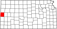 Location in the U.S. state of Kansas | |
 Kansas's location in the U.S. | |
| Founded | March 20, 1873 |
| Named for | Horace Greeley |
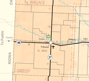
| Seat | Tribune |
| Largest city | Tribune |
| Area | |
| • Total | 778 sq mi (2,015 km2) |
| • Land | 778 sq mi (2,015 km2) |
| • Water | 0.0 sq mi (0 km2), 0.0% |
| Population (est.) | |
| • (2016) | 1,296 |
| • Density | 1.6/sq mi (0.6/km2) |
| Congressional district | 1st |
| Time zone | Mountain: UTC−7/−6 |
| Website | greeleycounty.org |
Greeley County (county code GL) is a county located in western Kansas, in the Central United States. As of the 2010 census, the population was 1,247,[1] which makes it the least populous county in Kansas. Its county seat and largest city is Tribune.[2] The county is named after Horace Greeley[3] of Chappaqua, New York, editor of the New York Tribune. Greeley encouraged western settlement with the motto "Go West, young man".[4]
History
Early history
For many millennia, the Great Plains of North America was inhabited by nomadic Native Americans. From the 16th century to 18th century, the Kingdom of France claimed ownership of large parts of North America. In 1762, after the French and Indian War, France secretly ceded New France to Spain, per the Treaty of Fontainebleau.
19th century
In 1802, Spain returned most of the land to France, but keeping title to about 7,500 square miles. In 1803, most of the land for modern day Kansas was acquired by the United States from France as part of the 828,000 square mile Louisiana Purchase for 2.83 cents per acre.
In 1854, the Kansas Territory was organized, then in 1861 Kansas became the 34th U.S. state. In 1873, Greeley County was established.
Geography
According to the U.S. Census Bureau, the county has a total area of 778 square miles (2,020 km2), all of which is land.[5] It is the largest of five United States counties and twelve (Virginia) independent cities that officially have no water area.
Adjacent counties
- Wallace County (north)
- Wichita County (east/Central Time border)
- Hamilton County (south)
- Prowers County, Colorado (southwest)
- Kiowa County, Colorado (west)
- Cheyenne County, Colorado (northwest)
Demographics
| Historical population | |||
|---|---|---|---|
| Census | Pop. | %± | |
| 1890 | 1,264 | — | |
| 1900 | 493 | −61.0% | |
| 1910 | 1,335 | 170.8% | |
| 1920 | 1,028 | −23.0% | |
| 1930 | 1,712 | 66.5% | |
| 1940 | 1,638 | −4.3% | |
| 1950 | 2,010 | 22.7% | |
| 1960 | 2,087 | 3.8% | |
| 1970 | 1,819 | −12.8% | |
| 1980 | 1,845 | 1.4% | |
| 1990 | 1,774 | −3.8% | |
| 2000 | 1,534 | −13.5% | |
| 2010 | 1,247 | −18.7% | |
| Est. 2016 | 1,296 | [6] | 3.9% |
| U.S. Decennial Census[7] 1790-1960[8] 1900-1990[9] 1990-2000[10] 2010-2016[1] | |||
As of the 2000 census,[11] there were 1,534 people, 602 households, and 414 families residing in the county. The population density was 2 people per square mile (1/km²). There were 712 housing units at an average density of 1 per square mile (0/km²). The racial makeup of the county was 93.09% White, 0.26% Native American, 0.20% Black or African American, 0.13% Pacific Islander, 0.07% Asian, 5.22% from other races, and 1.04% from two or more races. Hispanic or Latino of any race were 11.54% of the population.
There were 602 households out of which 34.20% had children under the age of 18 living with them, 61.10% were married couples living together, 4.50% had a female householder with no husband present, and 31.20% were non-families. 28.60% of all households were made up of individuals and 12.80% had someone living alone who was 65 years of age or older. The average household size was 2.50 and the average family size was 3.10.
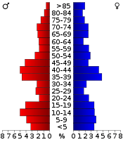
In the county, the population was spread out with 28.20% under the age of 18, 6.80% from 18 to 24, 27.30% from 25 to 44, 19.90% from 45 to 64, and 17.70% who were 65 years of age or older. The median age was 39 years. For every 100 females there were 98.40 males. For every 100 females age 18 and over, there were 92.80 males.
The median income for a household in the county was $34,605, and the median income for a family was $45,625. Males had a median income of $29,018 versus $18,984 for females. The per capita income for the county was $19,974. About 8.20% of families and 11.60% of the population were below the poverty line, including 14.20% of those under age 18 and 6.80% of those age 65 or over.
Government
County
As of January 1, 2009, Greeley County and the City of Tribune have operated as a unified government.[12] The resulting government consists of a five-member commission with two members elected by city residents, two by rural residents, and one at-large.[13] Similar to Wyandotte County, the only other consolidated city-county in the state, part of the county was not included: Horace decided against consolidation.[14]
Presidential elections
| Year | Republican | Democratic | Third Parties |
|---|---|---|---|
| 2016 | 82.2% 534 | 12.8% 83 | 5.1% 33 |
| 2012 | 81.0% 543 | 16.9% 113 | 2.1% 14 |
| 2008 | 79.3% 591 | 20.3% 151 | 0.4% 3 |
| 2004 | 79.5% 584 | 18.8% 138 | 1.8% 13 |
| 2000 | 78.2% 628 | 17.8% 143 | 4.0% 32 |
| 1996 | 72.0% 567 | 20.4% 161 | 7.6% 60 |
| 1992 | 57.7% 504 | 21.9% 191 | 20.4% 178 |
| 1988 | 59.3% 506 | 37.2% 317 | 3.5% 30 |
| 1984 | 73.3% 699 | 23.8% 227 | 2.9% 28 |
| 1980 | 63.4% 600 | 24.8% 235 | 11.8% 112 |
| 1976 | 43.4% 389 | 53.5% 479 | 3.1% 28 |
| 1972 | 68.5% 639 | 22.7% 212 | 8.8% 82 |
| 1968 | 59.9% 465 | 29.2% 227 | 10.9% 85 |
| 1964 | 44.8% 388 | 54.2% 469 | 1.0% 9 |
| 1960 | 70.6% 645 | 28.7% 262 | 0.8% 7 |
| 1956 | 77.1% 599 | 22.4% 174 | 0.5% 4 |
| 1952 | 79.1% 725 | 19.7% 181 | 1.2% 11 |
| 1948 | 53.3% 391 | 44.5% 326 | 2.2% 16 |
| 1944 | 63.0% 378 | 35.8% 215 | 1.2% 7 |
| 1940 | 64.6% 497 | 34.8% 268 | 0.7% 5 |
| 1936 | 50.5% 396 | 49.4% 388 | 0.1% 1 |
| 1932 | 42.6% 359 | 52.3% 440 | 5.1% 43 |
| 1928 | 78.3% 439 | 21.6% 121 | 0.2% 1 |
| 1924 | 64.2% 357 | 13.5% 75 | 22.3% 124 |
| 1920 | 69.5% 273 | 23.7% 93 | 6.9% 27 |
| 1916 | 43.6% 210 | 34.9% 168 | 21.6% 104 |
| 1912 | 35.6% 95 | 12.4% 33 | 52.1% 139[lower-alpha 1] |
| 1908 | 64.6% 206 | 27.9% 89 | 7.5% 24 |
| 1904 | 85.6% 149 | 8.1% 14 | 6.3% 11 |
| 1900 | 75.6% 118 | 23.1% 36 | 1.3% 2 |
| 1896 | 60.8% 121 | 38.2% 76 | 1.0% 2 |
| 1892 | 67.9% 241 | 32.1% 114 | |
| 1888 | 59.0% 422 | 25.2% 180 | 15.8% 113 |
Laws
The Kansas Constitution was amended in 1986 to allow the sale of alcoholic liquor by the individual drink with the approval of voters. Greeley County remained a prohibition, or "dry", county until 2008, when voters approved to allow sales of liquor by the drink.[16]
Education
Unified school districts
Communities
Cities
Unincorporated community
Ghost Towns
- Colokan
- Hector
- Walkinghood
- Whitelaw
Townships
Greeley County was previously divided into three townships. However, in 1992, Colony Township and Harrison Township were merged into Tribune Township, leaving only one township for the county. This was not reported to the U.S. census until 2006, thus the 2000 census did not reflect the merger, but the 2010 census did.[17]
None of the cities within the county are considered governmentally independent, and all figures for the townships include those of the cities. In the following table, the population center is the largest city (or cities) included in that township's population total, if it is of a significant size.
| Township | FIPS | Population center |
Population | Population density /km² (/sq mi) |
Land area km² (sq mi) | Water area km² (sq mi) | Water % | Geographic coordinates |
|---|---|---|---|---|---|---|---|---|
| Colony | 14975 | 172 | 0 (0) | 919 (355) | 0 (0) | 0% | 38°28′10″N 101°55′42″W / 38.46944°N 101.92833°W | |
| Harrison | 30325 | 107 | 0 (1) | 511 (197) | 0 (0) | 0% | 38°21′25″N 101°41′14″W / 38.35694°N 101.68722°W | |
| Tribune | 71475 | Tribune | 1,255 | 2 (6) | 586 (226) | 0 (0) | 0% | 38°31′51″N 101°44′36″W / 38.53083°N 101.74333°W |
| Sources: "Census 2000 U.S. Gazetteer Files". U.S. Census Bureau, Geography Division. Archived from the original on 2002-08-02. | ||||||||
See also
|
|
References
- 1 2 "State & County QuickFacts". United States Census Bureau. Archived from the original on July 11, 2011. Retrieved July 24, 2014.
- ↑ "Find a County". National Association of Counties. Archived from the original on 2011-05-31. Retrieved 2011-06-07.
- ↑ Gannett, Henry (1905). The Origin of Certain Place Names in the United States. Govt. Print. Off. p. 143.
- ↑ Josiah Busnell Grinnell (1891). Men and Events of Forty Years. Boston: D. Lothrop. p. 87. Retrieved 2009-02-13.
- ↑ "US Gazetteer files: 2010, 2000, and 1990". United States Census Bureau. 2011-02-12. Retrieved 2011-04-23.
- ↑ "Population and Housing Unit Estimates". Retrieved June 9, 2017.
- ↑ "U.S. Decennial Census". United States Census Bureau. Archived from the original on May 12, 2015. Retrieved July 24, 2014.
- ↑ "Historical Census Browser". University of Virginia Library. Retrieved July 24, 2014.
- ↑ "Population of Counties by Decennial Census: 1900 to 1990". United States Census Bureau. Retrieved July 24, 2014.
- ↑ "Census 2000 PHC-T-4. Ranking Tables for Counties: 1990 and 2000" (PDF). United States Census Bureau. Retrieved July 24, 2014.
- ↑ "American FactFinder". United States Census Bureau. Archived from the original on 2013-09-11. Retrieved 2008-01-31.
- ↑ http://www.greeleycounty.org/?page_id=947
- ↑ Greeley County residents pass unification Archived 2009-03-21 at the Wayback Machine., Garden City Telegram, 2007-11-07. Accessed 2007-11-08.
- ↑ TRIBUNE | City and county to unify, The Kansas City Star, 2007-11-07. Accessed 2007-11-08.
- ↑ http://uselectionatlas.org/RESULTS
- ↑ "Map of Wet and Dry Counties". Alcoholic Beverage Control, Kansas Department of Revenue. November 2010. Archived from the original on 2011-09-30. Retrieved 2011-08-01.
- ↑ Kansas: 2010, Population and Housing unit Counts, pdf p. 21 (2012)
- Notes
- ↑ This total comprises 106 votes (39.70 percent) for Progressive Theodore Roosevelt (who carried the county) and 33 votes (12.36 percent) for Socialist Eugene V. Debs.
Further reading
External links
| Wikimedia Commons has media related to Greeley County, Kansas. |
- County
- Other
- Maps
- Greeley County Maps: Current, Historic, KDOT
- Kansas Highway Maps: Current, Historic, KDOT
- Kansas Railroad Maps: Current, 1996, 1915, KDOT and Kansas Historical Society
Places adjacent to Greeley County, Kansas | |
|---|---|
Municipalities and communities of Greeley County, Kansas, United States | ||
|---|---|---|
| Cities | | |
| Unincorporated community | ||
| Townships | ||
