Wabaunsee County, Kansas
| Wabaunsee County, Kansas | |
|---|---|
| County | |
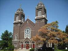 Sacred Heart Catholic Church in Newbury | |
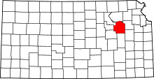 Location in the U.S. state of Kansas | |
 Kansas's location in the U.S. | |
| Founded | 1859 |
| Named for | Chief Waubonsie |
| Seat | Alma |
| Largest city | Alma |
| Area | |
| • Total | 800 sq mi (2,072 km2) |
| • Land | 794 sq mi (2,056 km2) |
| • Water | 5.3 sq mi (14 km2), 7% |
| Population (est.) | |
| • (2016) | 6,891 |
| • Density | 8.7/sq mi (3.4/km2) |
| Congressional district | 1st |
| Time zone | Central: UTC−6/−5 |
| Website | County Website |
Wabaunsee County (standard abbreviation: WB) is a county located in the U.S. state of Kansas. As of the 2010 census, the county population was 7,053.[1] Its county seat is Alma.[2] The county was created by the territorial legislature of Kansas Territory on March 25, 1859,[3] and was named for a chief of the Potawatomi Indians.[3]
History

19th century
For millennia, the land now known as Kansas was inhabited by Native Americans. In 1803, most of modern Kansas was secured by the United States as part of the Louisiana Purchase. The first white settlers in the area were said to have been a band of outlaws known as the McDaniel Gang.[3]
In 1854, the Kansas Territory was organized and Wabaunsee County was created by the territorial legislature on March 25, 1859.[3] The name used since 1859 is derived from the Potawatomi "Wah-bon-seh", meaning "dawn of day" literally, and it was the name of the chief of the Potawatomi Indians.[3] Originally, the county was named Richardson, after William Alexander Richardson, a congressman from Illinois, who introduced the first Kansas and Nebraska Bill in the House of Representatives, which made certain Indian lands territories in 1854.[4]
Also in 1854, the Beecher Bible and Rifle Church was established by a group of free-staters, who had rifles shipped to the church to be used in the free-state effort in boxes marked Bibles.[3] Captain William Mitchell, Jr., a seaman who joined the Beecher Bible and Rifle Colony that settled in Wabaunsee, played an important role in the county settlement and with the underground railroad.[3]
The county's first church, Wabaunsee Church of Christ, was founded in June 1857.[3]
In 1861 Kansas became the 34th U.S. state, entering the union as a free state.

The first railroad to be built through Wabaunsee County was the Atchison, Topeka, and Santa Fe in 1880.[5] In 1887, the Chicago, Kansas and Nebraska Railway built a main line from Topeka to Herington.[6] This main line connected Topeka, Valencia, Willard, Maple Hill, Vera, Paxico, McFarland, Alma, Volland, Alta Vista, Dwight, White City, Latimer, Herington.
20th century
A massive drought beginning in 1930 resulted in a series of dust storms that lasted until 1941. The drought combined with the onset of the Great Depression, forced farmers off the land. This ecological disaster caused an exodus of many farmers to escape from the hostile environment of Kansas.[7][8] As the world demand for wheat plummeted, rural Kansas became poverty-stricken. The state became an eager participant in such major New Deal relief programs as the Civil Works Administration, the Federal Emergency Relief Administration, the Civilian Conservation Corps, the Works Progress Administration, which put tens of thousands of Kansans to work as unskilled labor.[9] Republican Governor Alf Landon also employed emergency measures, including a moratorium on mortgage foreclosures and a balanced budget initiative.[10] The Agricultural Adjustment Administration succeeded in raising wheat prices after 1933, thus alleviating the most serious distress.[11]
During World War II, Wabaunsee County had a POW camp where the Allies sent German POWs. It was believed that the prisoners would be less of a security risk in North America, where there were fewer Nazi sympathizers, than they would be in Europe. The prisoners were paid $0.40 per hour and granted a daily noon lunch, in exchange for their help on farms and bridges throughout the region.[12]
Geography
According to the U.S. Census Bureau, the county has a total area of 800 square miles (2,100 km2), of which 794 square miles (2,060 km2) is land and 5.3 square miles (14 km2) (0.7%) is water.[13]
Adjacent counties
- Pottawatomie County (north)
- Shawnee County (east)
- Osage County (southeast)
- Lyon County (south)
- Morris County (southwest)
- Geary County (west)
- Riley County (northwest)
Demographics
| Historical population | |||
|---|---|---|---|
| Census | Pop. | %± | |
| 1860 | 1,023 | — | |
| 1870 | 3,362 | 228.6% | |
| 1880 | 8,756 | 160.4% | |
| 1890 | 11,720 | 33.9% | |
| 1900 | 12,813 | 9.3% | |
| 1910 | 12,721 | −0.7% | |
| 1920 | 11,424 | −10.2% | |
| 1930 | 10,830 | −5.2% | |
| 1940 | 9,219 | −14.9% | |
| 1950 | 7,212 | −21.8% | |
| 1960 | 6,648 | −7.8% | |
| 1970 | 6,397 | −3.8% | |
| 1980 | 6,867 | 7.3% | |
| 1990 | 6,603 | −3.8% | |
| 2000 | 6,885 | 4.3% | |
| 2010 | 7,053 | 2.4% | |
| Est. 2016 | 6,891 | [14] | −2.3% |
| U.S. Decennial Census[15] 1790-1960[16] 1900-1990[17] 1990-2000[18] 2010-2016[1] | |||

Wabaunsee County is part of the Topeka, KS Metropolitan Statistical Area.
As of the census[19] of 2000, there were 6,885 people, 2,633 households, and 1,958 families residing in the county. The population density was 9 people per square mile (3/km²). There were 3,033 housing units at an average density of 4 per square mile (1/km²). The racial makeup of the county was 97.24% White, 0.46% Black or African American, 0.49% Native American, 0.15% Asian, 0.06% Pacific Islander, 0.60% from other races, and 1.00% from two or more races. 1.86% of the population were Hispanic or Latino of any race.
There were 2,633 households out of which 33.50% had children under the age of 18 living with them, 64.30% were married couples living together, 6.30% had a female householder with no husband present, and 25.60% were non-families. 23.00% of all households were made up of individuals and 10.80% had someone living alone who was 65 years of age or older. The average household size was 2.57 and the average family size was 3.01.
In the county, the population was spread out with 26.70% under the age of 18, 6.20% from 18 to 24, 26.70% from 25 to 44, 24.80% from 45 to 64, and 15.60% who were 65 years of age or older. The median age was 40 years. For every 100 females, there were 102.50 males. For every 100 females age 18 and over, there were 101.30 males.
The median income for a household in the county was $41,710, and the median income for a family was $47,500. Males had a median income of $31,629 versus $23,148 for females. The per capita income for the county was $17,704. About 5.80% of families and 7.30% of the population were below the poverty line, including 8.40% of those under age 18 and 7.90% of those age 65 or over.
Government
Presidential elections
| Year | Republican | Democratic | Third Parties |
|---|---|---|---|
| 2016 | 70.2% 2,372 | 23.0% 776 | 6.9% 232 |
| 2012 | 69.1% 2,256 | 28.1% 918 | 2.9% 93 |
| 2008 | 68.0% 2,395 | 29.4% 1,036 | 2.6% 90 |
| 2004 | 70.2% 2,531 | 27.8% 1,001 | 2.0% 72 |
| 2000 | 63.8% 2,182 | 30.0% 1,025 | 6.2% 213 |
| 1996 | 55.7% 1,884 | 28.6% 966 | 15.8% 534 |
| 1992 | 37.2% 1,254 | 25.2% 851 | 37.6% 1,269 |
| 1988 | 58.5% 1,737 | 39.3% 1,166 | 2.2% 64 |
| 1984 | 72.7% 2,276 | 25.7% 805 | 1.6% 49 |
| 1980 | 68.0% 2,255 | 25.7% 853 | 6.3% 209 |
| 1976 | 57.6% 1,921 | 40.6% 1,354 | 1.8% 61 |
| 1972 | 76.8% 2,461 | 20.7% 662 | 2.5% 80 |
| 1968 | 64.2% 1,979 | 22.5% 695 | 13.3% 410 |
| 1964 | 58.3% 1,839 | 40.8% 1,287 | 0.8% 26 |
| 1960 | 70.6% 2,351 | 29.1% 969 | 0.3% 11 |
| 1956 | 76.6% 2,650 | 23.2% 802 | 0.2% 6 |
| 1952 | 81.0% 3,182 | 18.7% 736 | 0.2% 9 |
| 1948 | 66.8% 2,437 | 31.9% 1,162 | 1.3% 49 |
| 1944 | 76.0% 2,839 | 23.4% 873 | 0.7% 26 |
| 1940 | 73.6% 3,481 | 25.6% 1,212 | 0.7% 34 |
| 1936 | 55.5% 2,809 | 44.2% 2,235 | 0.3% 15 |
| 1932 | 47.4% 2,304 | 50.7% 2,465 | 1.9% 93 |
| 1928 | 71.9% 3,099 | 27.6% 1,189 | 0.5% 23 |
| 1924 | 65.9% 2,742 | 15.2% 633 | 18.9% 786 |
| 1920 | 77.6% 2,859 | 21.2% 782 | 1.1% 42 |
| 1916 | 59.0% 2,640 | 38.1% 1,706 | 3.0% 132 |
| 1912 | 26.8% 783 | 38.6% 1,128 | 34.6% 1,009 |
| 1908 | 60.3% 1,849 | 37.9% 1,163 | 1.9% 57 |
| 1904 | 71.4% 2,016 | 24.4% 688 | 4.2% 118 |
| 1900 | 58.1% 1,793 | 40.9% 1,263 | 1.0% 32 |
| 1896 | 51.8% 1,586 | 47.1% 1,442 | 1.1% 34 |
| 1892 | 46.8% 1,356 | 53.2% 1,540 | |
| 1888 | 62.5% 1,708 | 35.1% 960 | 2.3% 64 |
Wabaunsee County is overwhelmingly Republican. No Democratic Presidential candidate has won Wabaunsee County since Franklin D. Roosevelt in 1932, and since at least 1888 only Roosevelt in 1932 and 1936, plus William Jennings Bryan in 1896, have reached 41 percent of the county’s vote for the Democratic Party. The county was however one of three Kansas counties – Anderson and Jefferson being the other two – to give a plurality to Ross Perot in 1992.
Laws
Wabaunsee County was a prohibition, or "dry", county until the Kansas Constitution was amended in 1986 and voters approved the sale of alcoholic liquor by the individual drink with a 30 percent food sales requirement.[21]
Education
Unified school districts
Communities
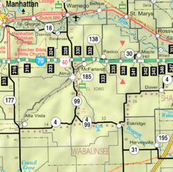
Cities
- Alma
- Alta Vista
- Eskridge
- Harveyville
- Maple Hill
- McFarland
- Paxico
- St. Marys (part)
- Willard (part)
Unincorporated communities
Ghost town
Townships
Wabaunsee County is divided into thirteen townships. None of the cities within the county are considered governmentally independent, and all figures for the townships include those of the cities. In the following table, the population center is the largest city (or cities) included in that township's population total, if it is of a significant size.
| Township | FIPS | Population center |
Population | Population density /km² (/sq mi) |
Land area km² (sq mi) | Water area km² (sq mi) | Water % | Geographic coordinates |
|---|---|---|---|---|---|---|---|---|
| Alma | 01375 | Alma | 1,137 | 11 (28) | 104 (40) | 0 (0) | 0% | 39°1′8″N 96°17′33″W / 39.01889°N 96.29250°W |
| Farmer | 23125 | 119 | 1 (2) | 172 (66) | 0 (0) | 0.07% | 38°55′37″N 96°18′44″W / 38.92694°N 96.31222°W | |
| Garfield | 25850 | Alta Visa | 590 | 5 (13) | 118 (45) | 0 (0) | 0.09% | 38°51′44″N 96°27′20″W / 38.86222°N 96.45556°W |
| Kaw | 36150 | 242 | 2 (6) | 110 (42) | 2 (1) | 1.55% | 39°10′16″N 96°9′46″W / 39.17111°N 96.16278°W | |
| Maple Hill | 44525 | Maple Hill | 930 | 5 (13) | 190 (73) | 1 (0) | 0.55% | 39°4′43″N 96°0′52″W / 39.07861°N 96.01444°W |
| Mill Creek | 46725 | Lake Wabaunsee | 293 | 2 (4) | 192 (74) | 1 (0) | 0.43% | 38°53′23″N 96°11′23″W / 38.88972°N 96.18972°W |
| Mission Creek | 47300 | 495 | 2 (6) | 209 (81) | 0 (0) | 0.04% | 38°55′49″N 96°3′0″W / 38.93028°N 96.05000°W | |
| Newbury | 50275 | Paxico / McFarland | 1,045 | 5 (13) | 203 (78) | 0 (0) | 0.06% | 39°3′44″N 96°11′18″W / 39.06222°N 96.18833°W |
| Plumb | 56800 | Harveyville | 640 | 5 (13) | 129 (50) | 0 (0) | 0.17% | 38°47′56″N 95°58′36″W / 38.79889°N 95.97667°W |
| Rock Creek | 60650 | 84 | 0 (1) | 171 (66) | 0 (0) | 0.05% | 38°46′58″N 96°18′15″W / 38.78278°N 96.30417°W | |
| Wabaunsee | 74250 | Wabaunsee | 455 | 3 (7) | 172 (66) | 2 (1) | 1.05% | 39°6′57″N 96°18′21″W / 39.11583°N 96.30583°W |
| Washington | 75800 | 83 | 1 (1) | 148 (57) | 0 (0) | 0.02% | 38°57′49″N 96°25′14″W / 38.96361°N 96.42056°W | |
| Wilmington | 79525 | Eskridge | 772 | 5 (13) | 150 (58) | 0 (0) | 0.03% | 38°49′54″N 96°6′14″W / 38.83167°N 96.10389°W |
See also
|
|
References
- 1 2 "State & County QuickFacts". United States Census Bureau. Archived from the original on July 15, 2014. Retrieved July 29, 2014.
- ↑ "Find a County". National Association of Counties. Retrieved 2011-06-07.
- 1 2 3 4 5 6 7 8 Wabaunsee County, Kansas, Kansapedia. (accessed July 27, 2013)
- ↑ Wabaunsee County History.
- ↑ Blackmar, Frank Wilson (1912). Kansas: A Cyclopedia of State History, Volume 2. Standard Publishing Company. p. 853.
- ↑ Rock Island Rail History
- ↑ Timothy Eagan, The Worst Hard Tim : the Untold Story of Those Who Survived the Great American Dust Bowl (Houghton Mifflin, 2006)
- ↑ Craig Miner,Next Year Country: Dust to Dust in Western Kansas, 1890-1940 (2007)
- ↑ Peter Fearon, "Kansas History and the New Deal Era," Kansas History, Autumn 2007, Vol. 30 Issue 3, pp 192-223
- ↑ Donald R. McCoy, Landon of Kansas (1966)
- ↑ Peter Fearon, "Regulation and Response: Kansas Wheat Farmers and the New Deal," Rural History, Oct 2007, Vol. 18 Issue 2, pp 245-264
- ↑ "Lake Wabaunsee". Lake Wabaunsee. Retrieved 2017-09-12.
- ↑ "US Gazetteer files: 2010, 2000, and 1990". United States Census Bureau. 2011-02-12. Retrieved 2011-04-23.
- ↑ "Population and Housing Unit Estimates". Retrieved June 9, 2017.
- ↑ "U.S. Decennial Census". United States Census Bureau. Retrieved July 29, 2014.
- ↑ "Historical Census Browser". University of Virginia Library. Retrieved July 29, 2014.
- ↑ "Population of Counties by Decennial Census: 1900 to 1990". United States Census Bureau. Retrieved July 29, 2014.
- ↑ "Census 2000 PHC-T-4. Ranking Tables for Counties: 1990 and 2000" (PDF). United States Census Bureau. Retrieved July 29, 2014.
- ↑ "American FactFinder". United States Census Bureau. Retrieved 2008-01-31.
- ↑ http://uselectionatlas.org/RESULTS
- ↑ "Map of Wet and Dry Counties". Alcoholic Beverage Control, Kansas Department of Revenue. November 2006. Archived from the original on 2007-10-08. Retrieved 2007-12-28.
Further reading
- Standard Atlas of Wabaunsee County, Kansas; Geo. A. Ogle & Co; 76 pages; 1919.
- Standard Atlas of Wabaunsee County, Kansas; Geo. A. Ogle & Co; 47 pages; 1902.
- Atlas of Wabaunsee County, Kansas; Gillen & Davy; 51 pages; 1885.
External links
| Wikimedia Commons has media related to Wabaunsee County, Kansas. |
- County
- Historical
- Maps
- Wabaunsee County Maps: Current, Historic, KDOT
- Kansas Highway Maps: Current, Historic, KDOT
- Kansas Railroad Maps: Current, 1996, 1915, KDOT and Kansas Historical Society
Places adjacent to Wabaunsee County, Kansas | ||||||||||
|---|---|---|---|---|---|---|---|---|---|---|
| ||||||||||
Municipalities and communities of Wabaunsee County, Kansas, United States | ||
|---|---|---|
| Cities | | |
| Unincorporated communities | ||
| Ghost towns | ||
| Footnotes | ‡This populated place also has portions in an adjacent county or counties | |
